Cubbington Neighbourhood Development Plan - Regulation 16 Submission
3.0 Cubbington Neighbourhood Area View responses
Introduction
3.1 Cubbington neighbourhood area is in southeast Warwickshire approximately 2 miles northeast of Royal Leamington Spa and 6 miles south of Coventry. The designated neighbourhood area covers approximately 2,112 acres (850 hectares). At the neighbourhood area's heart is Cubbington village, to the northwest of which is New Cubbington an estate of houses built largely in the 1950's and directly adjoining Lillington, a suburb of Royal Leamington Spa (Figure 3).
Figure 3 Designated Cubbington Neighbourhood Area and Surroundings
The area today
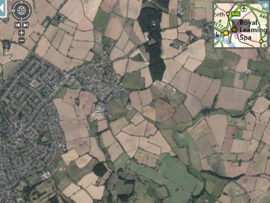
3.2 Cubbington village is reasonably compact, and occupies a central location in the parish (the parish boundary and neighbourhood area boundary are the same) The village is situated in a shallow valley on a tributary stream (Pingle Brook) to the River Leam, which, in turn, forms the boundary with Offchurch parish to the south east (Figure 4).
3.3 The last Census figures available from 2011 (the 2021 Census figures are still to be published at parish level) show that Cubbington had a population of 3,929 usual residents. Of these, 99.2% lived in households and 0.8% lived in communal establishments. The average (mean) age of residents was 45.2 years, significantly higher than in Warwick District where the mean age is 39 years. In total, there were 1,688 household spaces. Of these, 1,660 (98.3%) had at least one usual resident and 28 (1.7%) had no usual residents.

Figure 4 Cubbington and surrounding countryside.
3.4 The type of housing in Cubbington is very different from that in the rest of Warwick District or in England. Whist the proportion of detached homes are relatively similar, Cubbington has almost twice the number of semi-detached homes (56.7%), but significantly fewer terraced and flat type homes. This reflects the different historic and economic development of the area, from nucleated village based on agriculture to more latterly a mix of village and suburban development at New Cubbington (Figure 5)
Figure 5 Dwelling Type (Source: 2011 Census)
3.5 Cubbington whilst benefitting from close links with Royal Leamington Spa also has several local facilities and services. These include a recreation ground and play area, village hall, local shops, Post Office, two schools, three pubs, the parish church of St Mary's and a Methodist Church.
3.6 Employment levels in the area are in line with local and national figures 71.6% of residents being economically active in 2011 (Warwick District 71.3%, England 69.9%). In terms of occupations Cubbington residents are employed in higher level occupations, such as technical, professional and managerial, similar to the wider District, but significantly higher levels than found in England (Figure 6). Most people either work from home or within a relatively short distance to their place of employment: (77% of residents working from home or 20 kilometres (12.4 miles) or less form their place of work (Figure 7).)
Figure 6 Occupation (Source: 2011 Census)
3.7 Thwaites established in 1937 remains the largest employer in the parish and covers a significant area to the southeast of Cubbington village. Thwaites builds and distributes lifting and handling equipment and is classed as a large employer with over 250 employees. The parish also includes a number of smaller employers many of which, but not all, are listed in Appendix 1.
3.8 The centre of Cubbington village is a Conservation Area (Figure 10), the parish also has 16 listed buildings (Appendix 2). There are no designated nature conservation sites within the neighbourhood area.
3.9 The neighbourhood area is served by the following principal transport links and services:
- Road
- M40 – North/South access at Longbridge (Jct.15, approx. 10 miles) or Bishops Tachbrook (Jct. 13, approx.6 miles).
- Rail
- West Coast Mainline Services from Coventry to Euston Station, London, or destinations north to Glasgow.
- Access to Chiltern Railways, Cross Country and West Midlands Trains services is available at Royal Leamington Spa (approx. 3 miles) including a service to Marylebone Station, London.
- Bus Service
- One Stagecoach bus route 67A, running between Royal Leamington Spa and Cubbington Village. The frequency of service was reduced in January 2019 and remains under constant review.
Figure 7 Cubbington Residents Travel to Work (Source: 2011 Census)
History and Development of Cubbington
3.10 The placename 'Cubbington' is first mentioned in the Domesday Book of 1086, where it appears as Cobintone and Cubintone. The name means 'the town or settlement of Cubba's people.

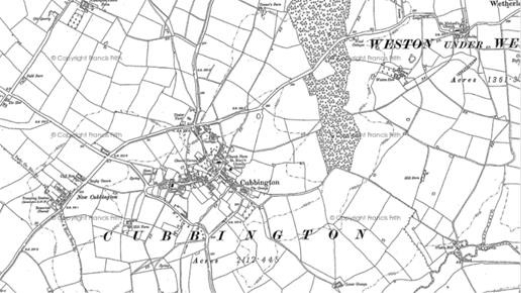
Figure 8 Cubbington 1886

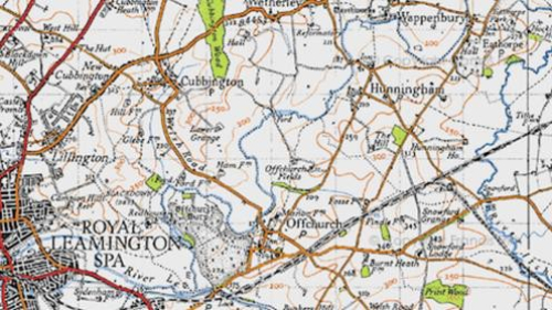
Figure 9 1948 map and the earliest signs of New Cubbington
3.11 Incremental development and growth took place from the 1800s up to the early 20th century then there was significant residential development from the 1950s onwards when development of New Cubbington commenced (Figure 9). The most recent developments along the Rugby Road have expanded the village footprint and further sites have been identified at Coventry Road (WDLP site H25) and "Cubbington East" (WDLP site H50) (Figure 11 in section 4 the Planning Policy Context section of this document).
3.12 The number of buildings and structures that are listed as being of historical interest or importance provide evidence of the development of the parish over the centuries. There are 16 in total distributed throughout the neighbourhood area. They include a wide variety of structures from St Mary's church to Offchurch Bridge (Appendix 2).

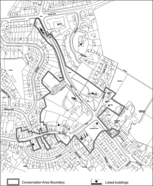
Figure 10 Cubbington Conservation Area and Listed Buildings
3.13 Listed Buildings within and clustered around Cubbington village are identified on the map in Figure 10. A significant number of these structures help to define the boundary The Conservation Area in Cubbington was designated in 1969 and extended in 2001.The current boundary of the Conservation Area is also shown on Figure 10. This represents the historic core of Cubbington village and is an incredibly important environmental and social characteristic to be protected and enhanced for the future.
3.14 The accelerating pace of growth in the built environment of Cubbing ton is illustrated in Table 1. This shows the dates and scale of significant residential development (including planning permissions granted) between 2011 and 2021. At 2011 there were 1,688 properties in Cubbington parish, by 2021 1,852 an increase of 10%
Table 1. Housing Development in Cubbington 2011-2021
|
2011-2014 |
2015-2019 |
2020-2022 |
Total |
|
|
Planning permissions |
118 |
155 |
92 |
365 |
|
Completions |
10 |
125 |
29 |
164 |
Source: WDC planning database
