
Publication (Regulation 19)
2 Development Strategy: South Warwickshire 2050
2.1 Vision and Strategic Objectives
2.1.1 The vision sets out what we want South Warwickshire to be like in 2050. It is a positive overarching statement that sets the context for the plan, policies and strategy that follow.
2.1.2 To enable the vision to be delivered, the subsequent objectives are proposed, reflecting the themes of both Council’s corporate plans and representing the social, environmental and economic issues of the area. They can be seen both as a ‘golden thread’ that flows through the SWLP connecting the various proposals and policies and goals that the plan, through the implementation of its policies, will achieve. The principles have also provided the context for the development of the plan itself, including informing the sustainability appraisal.
Vision
By 2050 South Warwickshire will be a flourishing, healthy and vibrant place where people will want to live, work and visit where our new settlements and neighbourhoods thrive alongside our existing communities. The Vision is to meet South Warwickshire’s sustainable development needs and strengthen local communities, while responding to the climate emergency. The SWLP will provide homes and jobs, boost and diversify the local economy, and provide appropriate infrastructure, in suitable locations, at the right time. High quality development will be physically and digitally connected, in accessible locations that promote active travel and convenient access to services and facilities by cycling, walking, public transport and private vehicle. New homes will meet the needs of all sections of society, and the economy will be bigger, greener and more resilient. By 2050 South Warwickshire will have adapted to the effects of climate change and mitigating against its causes, while minimising any further damage that might arise from development and drive towards net zero carbon. There will be positive environmental gain.
Strategic Objectives
To enable the vision to be delivered, the following Strategic Objectives are proposed:
Strategic Objective 1: Providing infrastructure in the right place at the right time
Ensuring development is supported by the timely delivery of infrastructure needed to support the growth in new homes and jobs.
Strategic Objective 2: Delivering homes that meet the needs of all our communities
Allowing growth in new homes that meet the diverse needs of our residents, including affordable housing, students, older people, specialist accommodation, and self and custom build housing along with the accommodation needs of our Traveller communities.
Strategic Objective 3: Developing opportunities for jobs and growing the economy
Accommodating the growth in employment opportunities that build upon our strong and diverse economy, including innovative industries and technologies, embracing the potential of a green economy.
Strategic Objective 4: Making effective use of land and natural resources
Maximising density and encouraging the effective use of previously developed land and natural resources.
Strategic Objective 5: Contributing towards Net Zero Carbon targets
Ensuring that new development is resilient to climate change and does not cause a net increase in carbon emissions, taking positive action to achieve net zero.
Strategic Objective 6: Creating attractive places and spaces
Promoting a high standard of design in new developments that are innovative, adaptable, low carbon, climate resilient, locally distinctive and respect the local character and setting of the existing settlements.
Strategic Objective 7: Conserving and enhancing our heritage and cultural assets
Protecting and enhancing the wealth of heritage and cultural assets in South Warwickshire, and where possible, enhancing access and understanding of these assets.
Strategic Objective 8: Improving the quality of life of our communities
Promoting health and wellbeing for people of all ages and reducing health inequalities.
Strategic Objective 9: Connecting people to places
Increasing and improving access to sustainable and active travel options that enhance connectivity between people and places and people and nature and by connecting people to centres, jobs, education, cultural facilities, green spaces and countryside.
Strategic Objective 10: Conserving and enhancing our environmental assets and working towards environmental net gain
Protecting what already exists and maximising opportunities for enhancement including improvements to the green and blue infrastructure network.
2.2 Achieving Sustainable Development
Policies within this section contribute to achieving the following Strategic Objectives:
SO4. Making effective use of land and natural resources
SO5. Contributing towards Net Zero Carbon targets
SO6. Creating attractive places and spaces
SO7. Conserving and enhancing our heritage and cultural assets
SO8. Improving the quality of life of our communities
SO9. Connecting people to places
SO10. Conserving and enhancing our environmental assets and working towards environmental net gain
2.2.1 Sustainable development is defined as meeting the needs of the current generation without compromising the ability of future generations to meet their own needs. The primary purpose of the Local Plan is to meet South Warwickshire’s development needs sustainably. This can only be done if there is an understanding and appreciation of the environment within which those needs are to be accommodated.
2.2.2 At the heart of the SWLP is the approach of securing Environmental Net Gain (ENG); to enhance the overall environmental value of development beyond statutory biodiversity requirements. ENG looks at using nature-based solutions to provide multiple benefits for people and nature, improving ecosystem services and natural capital.
2.2.3 ENG seeks to ensures that development improves the local environment above baseline protections and applies to biodiversity, carbon storage and reduction, soils, water quality and supply, air quality, natural flood management and green and blue infrastructure, reflecting the interdependence of natural assets and ecosystem services.
2.2.4 ENG is an emerging approach in England, building on statutory Biodiversity Net Gain (BNG) requirements under the Environment Act 2021 and the ambitions of the 25-Year Environment Plan and subsequent Environment Improvement Plans. Specific guidance and methodologies for assessing ENG across a range of environmental assets are expected to be published during the lifetime of this Plan. Nevertheless, given its environmental benefits, the South Warwickshire Local Plan aspires to achieve ENG wherever feasible.
2.2.5 To support this ambition, the principles of ENG are embedded across a range of policies in the Plan, including those relating to:
- Biodiversity
- Carbon sinks and sequestration
- Green and Blue Infrastructure
- Trees, hedgerows and woodland
- Flood risk and multi-functional Sustainable Urban Drainage Systems (SUDs)
- Pollution and Environmental Quality
- Water Supply and Wastewater Infrastructure
- Net Zero Building Design

2.2.6 These policies are identified throughout the Plan with a special ENG marker (see image to right), helping applicants and decision-makers apply ENG principles consistently across development proposals.
2.2.7 Although ENG is aspirational, it provides the overarching ambition for environmental improvement and guides the policies in this Plan. As national methodologies and guidance develop, the Councils will seek to apply ENG principles wherever feasible to support measurable benefits for biodiversity, ecosystem services, and local environmental quality. ENG is therefore a material consideration in shaping development proposals, without imposing mandatory requirements beyond statutory obligations.
2.2.8 This being said, development proposals are encouraged to make use of Natural England’s Environmental Benefits from Nature (EBN) tool at the early stages to maximise multifunctional land use and deliver gains for people and nature. Demonstrating alignment with the LNRS will also be encouraged when considering environmental gains.
Policy DS.1 (Strategic Policy)
Environmental Mitigation and Compensation
Development proposals should apply a proportionate mitigation hierarchy to potential environmental effects.
A. Mitigation Hierarchy
Development proposals will be expected to:
- avoid adverse environmental effects wherever possible;
- minimise and mitigate impacts where avoidance cannot reasonably be achieved; and
- provide compensation measures only as a last resort where significant residual effects remain following avoidance and mitigation.
The application of the mitigation hierarchy should be proportionate to the scale, nature and significance of the potential impact and informed by appropriate evidence.
B. Compensation Measures
Compensation measures will only be supported where it has been clearly demonstrated that:
- avoidance and mitigation are not reasonably achievable;
- residual effects cannot otherwise be satisfactorily addressed; and
- the proposed compensation measures are appropriate, deliverable, secured and capable of effective long-term management.
Where appropriate, compensation and off-site measures should align with local environmental priorities, including:
- the Warwickshire Local Nature Recovery Strategy;
- the Warwickshire, Coventry and Solihull Green Infrastructure Strategy; and
- the South Warwickshire Green and Blue Infrastructure and Open Space Study.
DS.1 ~ Development Management Considerations
This Policy does not override statutory or national policy tests, including biodiversity, heritage, flood risk, and other environmental safeguards.
Policy Justification
2.2.9 This policy ensures that development delivers environmental net gain and manages impacts on natural assets and ecosystem services in a proportionate, evidence-based way. Natural assets are elements of nature (e.g. trees, ponds, hedges) that work together to provide an ecosystem service. Ecosystem services are natural processes that have wider benefits to people and the economy, such as providing cleaner air, reducing flood risk cleaning water and providing carbon storage.
2.2.10 It applies the mitigation hierarchy from the National Planning Policy Framework which requires development to avoid, reduce, and, only as a last resort, compensate for significant environmental impacts. While the NPPF focuses on biodiversity, this policy extends the same approach to other environmental assets, including green infrastructure, landscape, and ecosystem services, where consistent with national policy. Councils in Warwickshire are supporting local ecosystem service markets to provide a coordinated approach to compensation. Applicants will be expected to demonstrate that they have considered these mechanisms to deliver measurable environmental benefits.
2.2.11 Compensation can be provided on-site or off-site and should align with local priorities including the Warwickshire Local Nature Recovery Strategy (LNRS), Warwickshire, Coventry and Solihull Green Infrastructure Strategy, and the South Warwickshire Green and Blue Infrastructure and Open Space Study.
2.3 Calculating South Warwickshire’s Development Needs
2.3.1 The SWLP refers to meetings the development needs of South Warwickshire. This is planning speak for ensuring that our communities, both now and in 25 years’ time, have sufficient homes and jobs to meet their needs. As well as providing additional homes and employment land, the SWLP will ensure that infrastructure is provided to support this development. This includes physical items such as transport facilities and schools, as well as the environmental and social infrastructure that are necessary for healthy and happy communities.
2.3.2 The basis for calculating how much additional employment floorspace and how many additional jobs are likely to be needed across South Warwickshire by 2050 is set out in various employment land technical studies (see the Policy Justification for Policy DS.3 below) and summarised in Figure 7. Strategic sites refer to large scale employment sites typically over 25ha and located on the Strategic Road Network, whereas non-strategic need refers to offices and industrial (B2/B8 class) uses to meet a local need on sites generally smaller than 25 hectares in size.
Figure 7: Employment Land Needs
|
(Figures in Hectares) |
Stratford-on-Avon |
Warwick |
South Warwickshire |
|---|---|---|---|
|
Non-strategic (2021-2050) |
199.9 |
121.2 |
321.1 |
|
Strategic (2022-2045) |
~ |
~ |
225 |
2.3.3 Taking into account existing commitments as set out in the accompanying Stratford-on-Avon and Warwick District Authority Monitoring Reports (i.e. those sites that already have planning consent and/or are under construction), the residual or net need across the plan period 1st April 2025 to 31st March 2050 is shown in Figure 8.
Figure 8: To-find Employment Needs
|
(Figures in Hectares) |
Stratford-on-Avon |
Warwick |
South Warwickshire |
|---|---|---|---|
|
Non-strategic |
199.9 |
121.2 |
321.1 |
|
Supply (as @ 1st April 2025) |
52.2 |
35.2 |
87.4 |
|
To-Find Figure |
147.7 |
86.0 |
233.7 |
|
Strategic |
~ |
~ |
225 |
|
Supply (as @ 1st April 2025) |
100 |
(205.1[2]) |
100 |
|
To-Find Figure |
~ |
~ |
125 |
2.3.4 The Government’s Standard Housing Method identifies the following housing needs for South Warwickshire as set out in Figure 9. The NPPF makes it clear that these figures should be treated as a minimum. Local planning authorities should use the standard method unless there are exceptional circumstances to utilise an alternative method. There are no exceptional circumstances.
Figure 9: Standard Housing Needs
|
May 2025 NPPF Standard Method |
Stratford-on-Avon |
Warwick |
South Warwickshire |
|---|---|---|---|
|
Total housing need (per annum) |
1,112 |
1,085 |
2,197 |
|
Total housing need (25 year plan period) |
27,800 |
27,125 |
54,925 |
2.3.5 The Standard Method figures are updated annually. Whilst it is acknowledged that there will be some fluctuation in the figures, it is unlikely that they will change substantially. Given the requirement to review plans every five years, the plan review will be the opportunity to reconsider the housing figures for South Warwickshire to ensure that the SWLP remains up-to-date and an appropriate strategy for meeting our housing needs. Fundamental change in the numbers, for example, arising from a change in methodology, could warrant an earlier review.
2.3.6 Taking into account existing commitments (i.e. those sites that already have planning consent and/or are under construction), as set out in the accompanying AMR the residual or net need across the plan period 1st April 2025 to 31st March 2050 is shown in Figure 10.
Figure 10: To-find Housing Need
|
Stratford-on-Avon |
Warwick |
South Warwickshire |
|
|---|---|---|---|
|
Total housing need (25 year plan period) |
27,800 |
27,125 |
54,925 |
|
Existing Commitments (as @ 1st April 2025) |
3,825 |
6,120 |
9,945 |
|
To-Find Figure |
23,975 |
21,005 |
44,980 |
2.3.7 In addition to the above, the SWLP needs to plan for the accommodation needs of Gypsy & Travellers, Travelling Showpeople and Boat Dwellers.
2.3.8 There is an overall accommodation need in the South Warwickshire (Stratford-on-Avon District and Warwick District) local authority areas over the Plan period to 2025 (a 25-year period) of 129 Gypsy and Traveller pitches. There is also an identified need for 20 additional Travelling Showpeople plots. The need for permanent residential moorings has been met by the conversion of leisure moorings to permanent residential moorings at a Marina at Napton following a Lawful Development Consent.
2.4 Needs Arising from Outside South Warwickshire
2.4.1 The NPPF requires local planning authorities to engage and co-operate positively and proactively with their neighbours to address cross boundary planning issues including development needs that cannot reasonably be met within those authority areas. The co-operative approach undertaken in preparing the SWLP is set out in the Maintaining Effective Co-operation Compliance Statement. South Warwickshire is within the wider Coventry and Warwickshire Housing Market Area (HMA) and partly within the Greater Birmingham, Black Country and Solihull HMA.
2.4.2 There is no shortfall of housing arising from the Coventry and Warwickshire HMA. A housing shortall from the Birmingham, Black Country and Solihull HMA has not been confirmed and nor has it been confirmed that any such shortfall should appropriately be met within South Warwickshire as opposed to other areas of the HMA, better related to the likely origin of the need.
2.4.3 The situation regarding employment needs from the Greater Birmingham and Black Country HMA is similar, albeit that the SWLP is providing for strategic employment that meets sub-regional needs. In respect of Coventry and Warwickshire, as set out below, the SWLP is overproviding on employment land relative to the non-strategic employment need identified for South Warwickshire. This overprovision of employment land in the SWLP and this additional headroom could therefore contribute towards any unmet employment needs arising from Coventry. With the introduction of Spatial Development Strategies, it will be for the West Midlands SDS to explore how needs can be met within its plan area in the first instance.
2.5 Development Strategy
Policies within this section contribute to achieving all of the Strategic Objectives (SO)
2.5.1 The Development Strategy sets out in broad terms the locations to which large scale and strategic growth should be directed; and conversely, those areas in which growth should be more controlled. In practical terms, the Development Strategy will help deliver the SWLP’s five overarching principles, determine where land is allocated for homes and employment uses, and the infrastructure and open space that supports this growth. In the SWLP, sustainability is achieved by:
- utilising available urban brownfield land
- building at densities that make efficient use of land
- using locations which are within reach of existing facilities, or providing new facilities on site
- allowing for smaller-scale growth outside of strategic areas
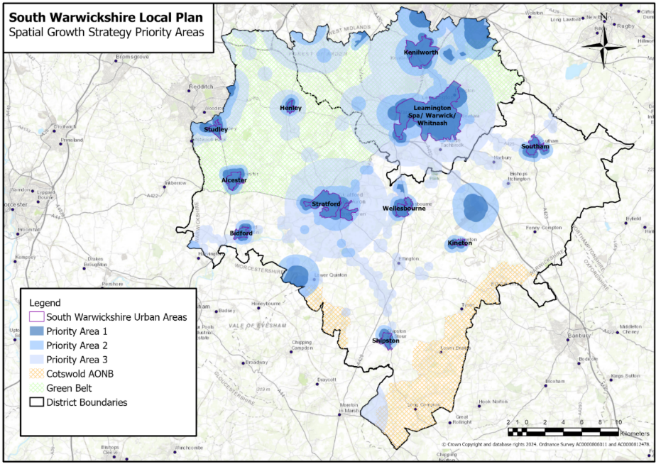
2.5.2 The Development Strategy will accommodate South Warwickshire’s housing and employment needs for the period to 2050. Figure 11 shows the priority areas that were identified to inform the preparation of the Development Strategy. The background to the development of the Priority Areas and subsequent selection of sites is set out in the accompanying Growth Strategy Topic Paper. The starting point for was the initial Scoping and Call for Sites consultation in 2021 that listed 7 spatial options, which were then refined through public consultation into 5 options before the hybrid strategy of sustainable travel and economy was agreed as the most appropriate approach for South Warwickshire.
- Option A: Rail Corridors.
- Option B: Main Bus Corridors.
- Option C: Main Road Corridors.
- Option D: Enterprise Hubs
- Option E: Socio-economic
- Option F: Main Urban Areas
- Option G: Dispersed
2.5.3 This preferred option was further refined into preferred locations informed by accessibility and connectivity technical work and the development of a spatial tool that combines sustainable travel and economic factors to identify the most suitable locations for development. This tool utilises buffer-informed proximity to the following characteristics:
- Urban land ~ prioritised in accordance with NPPF and the substantial weight given to the use of brownfield land.
- Sustainable Transport ~ Proximity to rail and bus stops is considered to be a key indicator of locations for growth, providing residents with sustainable options by shifting trips away from the private car.
- Economic Co-location ~ locating growth near existing employment sites allows for sustainable commuting opportunities by placing homes in proximity to potential places of work.
- Socioeconomic Improvements ~ This reflects the aspiration to leverage development to deliver community infrastructure that improves access to potential places of work.
2.5.3 As a result of this exercise, as shown in Figure 11, three priority areas have been developed as an overarching spatial tool for site selection, with Priority Area 1 typically indicating more sustainable locations and Priority Area 3 indicating less sustainable locations.
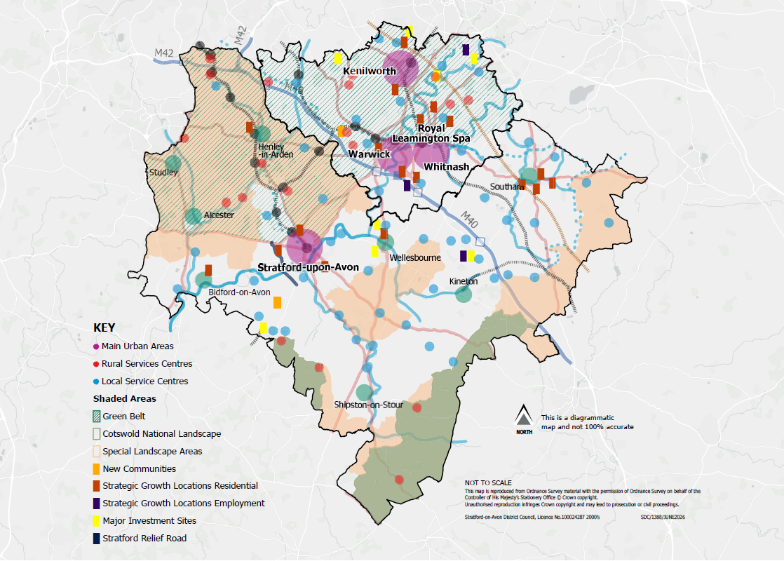
2.5.4 The approach takes account of the spatial drivers of development. Internally, these include the urban areas within South Warwickshire. Externally, South Warwickshire faces various directions but is most strongly aligned with Coventry as well as Birmingham and Solihull (far less so the Black Country). South Warwickshire is also influenced by London. The stronger interrelationships are therefore to the north and this is reflected in the Development Strategy which is summarised in the SWLP Key Diagram (Figure 12 overpage). A particular focus of the SWLP is on growing and diversifying the local economy which is an integral component of the wider Coventry and Warwickshire sub-region, with particular focus on automotive, advanced manufacturing and engineering and research and development. Again, the Development Strategy aligns with this ambition and seeks to couple locations of new homes and jobs into a core area that reflects the identified priority areas. Broadly speaking the SWLP follows the wider A46 corridor - a key national route that runs southwest-northeast and ultimately connects Bristol, Gloucester, Cheltenham, Tewkesbury, Worcester, Evesham, Stratford-upon-Avon, Warwick/Leamington, Kenilworth, Coventry and Leicester.
2.55 The Development Strategy has flowed from the earliest iterations of the SWLP and reflects its vision of achieving sustainable development whilst strengthening local communities and responding to the climate emergency. It does this by locating the majority of development in places that can be accessed by means other than the private car. Growth is focused on a small number of strategic allocations, including new settlements, so as to ensure that the necessary infrastructure can also be provided, benefitting both new and existing residents alike. The new settlements also provide the foundation for sustainable growth beyond 2050, providing certainty to communities in the long-term as well as enabling a continuation of housing delivery across South Warwickshire. The strategic locations also provide for employment and jobs, with many co-located to again reduce the need to travel and achieve balanced sustainable communities. Key employment sites are also safeguarded to help further grow the South Warwickshire economy. The focus on strategic growth locations also helps to preserve the wider rural character and landscapes of South Warwickshire, by rightly limiting growth in these more sensitive and inaccessible locations. The SWLP does however seek to strike a balance by allowing some growth to maintain the vitality of rural villages and support the rural economy.
2.5.6 Parts of South Warwickshire fall within the West Midlands Green Belt, the fundamental aim of which is to prevent the sprawl of the West Midlands conurbation, by keeping land permanently open. Notwithstanding this, some of South Warwickshire’s most sustainable locations fall within the Green Belt. For example, all of our train stations are either in or close to the Green Belt. The SWLP has therefore had to strike a careful balance between maintaining the Green Belt and carefully releasing land from the Green Belt to meet our development needs in the most appropriate locations. The justification for releasing land from the Green Belt is set out in the accompanying Green Belt Review.
Policy DS.2 (Strategic Policy)
Spatial Development Strategy
The distribution of development across South Warwickshire to 2050 reflects the vision of the SWLP to achieve sustainable travel and economic growth. Development will be focused at new settlements and within and adjacent to existing built-up areas at a scale sufficient to ensure appropriate services and infrastructure are delivered to support growth.
Development across South Warwickshire will be delivered through:
- Utilising previously developed land in urban areas as the highest priority;
- Where greenfield land is needed, concentrating this into larger areas of strategic growth to deliver the necessary infrastructure to make development sustainable for future communities
- Using locations which are within reach of existing facilities or providing new services on site where there is an identified need to achieve, where possible, 20-minute neighbourhood principles
- Building at densities that make efficient use of land
- Promoting active travel, improving access by walking, cycling and public transport for existing and future residents
In accordance with Policy DS.3, the development needs of South Warwickshire to 2050 will be met at the following locations as shown on the Policies Map:
A. New Communities
Two new communities scaled at a size to encourage self-sufficiency and the provision of essential services delivered in accordance with Policy DS.4:
- Hatton in accordance with Proposal HAT
- Long Marston Airfield in accordance with Proposal LMA
B. Strategic Growth Locations
Large-scale strategic areas of allocated growth adjacent to existing settlements, that are designed to deliver significant new infrastructure for future communities in combination with the needs of existing residents in accordance with Policy DS.4:
- Bidford-on-Avon – Land to North and East in accordance with Proposal BID.1
- Bishop’s Tachbrook – Land to West in accordance with Proposal BIT.1
- Bishop’s Tachbrook – Land to North-west in accordance with Proposal BIT.3
- Henley-in-Arden in accordance with Proposal HEN.1
- Kenilworth – Land to South in accordance with Proposal KEN.1
- Leamington Spa – Land to North (Blackdown) in accordance with Proposal LEA.1
- Leamington Spa – Land to North (Milverton) in accordance with Proposal LEA.2
- Leamington Spa – Land to East (Lillington) in accordance with Proposal LEA.3
- South of Coventry in accordance with Proposal COV.1
- South of Coventry – Kings Hill in accordance with Proposal COV.3
- Southam – Land to East in accordance with Proposal SOU.1
- Stratford - Land to North in accordance with Proposal STR.1
- Stratford – Land to South-east in accordance with Proposal STR.2
- Stratford – Land to West in accordance with Proposal STR.3
- Warwick – Land to West in accordance with Proposal WAR.1
- Wellesbourne North in accordance with Proposal WEL.1
The following locations will meet the strategic employment needs of South Warwickshire by 2050:
- Bishop’s Tachbrook – Land to South-west in accordance with Proposal BIT.2
- Coventry Airport in accordance with Proposal COV.2
- Gaydon Lighthorne Heath in accordance with Proposal GAY.1
Site Proposals for all of the above locations are set out in Chapter 8.
In addition, 71.8ha (net) of land at Gateway South and 16.3ha (net) of land at Whitley South, south of Coventry is allocated for strategic employment (E(g), B2 and B8 Class uses) in accordance with COV.4 and COV.5 below and MIS.C of Policy DS.10:
|
Ref. |
Site Name |
Size and Proposed Use |
|---|---|---|
|
COV.4 |
Gateway South, south of Coventry |
182ha (71.8 ha net strategic employment) |
|
COV.5 |
Whitley South, south of Coventry |
16.3ha net strategic employment |
C. Local Growth Locations
Smaller-scale allocations reflecting the needs to 2050 of smaller communities and intended to ensure a mix of available land and maintain a five-year housing land supply. These allocations rely primarily on existing infrastructure and will contribute proportionately to identified local infrastructure needs. Sites will be delivered in accordance with Policies DS.5, DS.6 and DS.7.
D. Other Growth Locations
Eight Major Investment Sites (MIS) have been identified, as shown on the Policies Map and set out in Policy DS.10. These are existing employment sites that will be safeguarded for continued investment. In accordance with Policy DS.10, proposals for the intensification of these sites for further employment, research use and investment will be supported in principle. Proposals for the expansion of these sites for the purposes set out above on adjacent land or land in close functional proximity will be supported in principle, subject to compliance with other relevant policies in the SWLP. Such proposals should demonstrate their integral relationship with the existing Major Investment Site.
Within the Primary Shopping Areas of the Main Urban Areas and Main Service Centres and the neighbourhood centres of New Settlements and Strategic Growth Locations identified in Policy DS.8 in accordance with Policy EC.5, as defined on the Policies Map, proposals for new town centre uses will be supported.
The SWLP will also support other development proposals on unallocated sites in accordance with Policy DS.8, on sites identified in Supplementary Plans, and on sites brought forward through Neighbourhood Development Plans or through Neighbourhood Development Orders and on Community Right to Build schemes.
DS.2 Development Management Considerations
In relation to retail proposals considered under Part D of the Policy, the sequential approach to be followed requires that locations are considered in the following order;
- Sites and buildings within the Primary Shopping Areas;
- Sites on the edge of the Primary Shopping Areas;
- Out-of-centre sites.
This policy is applicable to all proposals for new retail development, including new build, redevelopments, changes of use, intensifications and extensions.
In assessing proposals outside town centres, a Retail Impact Assessment will be required for proposals over 280 sqm (gross floorspace) to accompany any planning application. This should contain the following information:
- In relation to proving there are no sequentially preferential sites within or well connected to (300m of the primary shopping area) a full sequential test in accordance with Government guidance will be required will need to be carried out that recognises the requirements for developers and retailers to be flexible about the format, design and scale of the development and the amount of car parking required.
- Consideration of the impact of the proposal on existing, committed and planned public and private investment in a centre or centres in the catchment of the area of the proposal; and
- Consideration of the impact of the proposal on town centre vitality and viability, including local consumer choice and trade in the town centre and wider area, up to five years from the time the application is made. For major schemes where the full impact will not be realised in five years, the impact should also be assessed up to ten years from the time the application is made.
Outside town centres, the merits of individual schemes that may be smaller than 280sq.m (gross floorspace) will be considered on a case-by-case basis. In some cases, schemes may be required to submit a retail impact assessment.
Policy Justification
2.5.7 The Spatial Development Strategy guides development towards the most sustainable available locations in South Warwickshire. The strategy is informed by the ‘Sustainable Travel and Economy’ spatial growth strategy prepared at the Preferred Options stage and represents a positive contribution to the NPPF requirement for sustainable development, whilst ensuring that it significantly boosts the supply of homes and supports economic growth. It meets the development needs of South Warwickshire to 2050 in full.
2.5.8 The SWLP has considered a wide range of technical evidence to identify housing and employment land needs and determine the most sustainable locations for growth. This includes a site selection process conducted through the Housing and Economic Land Availability Assessment (HELAA), which assessed sites against detailed criteria such as flood risk, biodiversity, Green Belt impact and impact on heritage impacts. The Growth Strategy Topic Paper sets out in detail how the evolution of the SWLP approach.
2.5.9 In accordance with NPPF Paragraph 69, the SWLP establishes a clear housing requirement for the whole area and provides sufficient housing over the plan period to meet this target. Furthermore, to build a strong and competitive economy, the plan complies with NPPF Paragraphs 85 and 86 by identifying strategic sites for local and inward investment. This approach specifically addresses the locational requirements of different sectors, making provision for essential industrial clusters and networks, including the knowledge sector, freight, and logistics.
2.5.10 While NPPF Paragraph 124 requires the effective use of previously developed (brownfield) land, the Urban Capacity Study concluded that the capacity of such land within South Warwickshire is limited. Consequently, while urban brownfield land remains the highest priority, there is a recognised need for substantial additional greenfield sites to meet the districts' development requirements in full.
2.5.11 NPPF Paragraph 77 recognises that the supply of new homes is often best achieved through larger-scale development such as the identification of new settlements and strategic development allocations, due to their capacity to deliver the necessary on-site infrastructure and facilities. For the new settlements proposed, allocating a significant share of the projected growth to locations with 4,000-10,000 dwellings helps to ensure the delivery of on-site services, including schools and health facilities. This enables the creation of self-sufficient, sustainable 20-minute neighbourhoods, a key objective for housing growth. Elsewhere, growth is predominantly delivered through strategic growth locations which will have a greater impact on existing facilities and infrastructure but will be delivered at sufficient scale to mitigate these impacts and provide existing residents with significant benefits.
2.5.12 Strategic Growth Locations (SGLs) are focused on existing larger settlements with both districts. They have the capacity to substantial new infrastructure including as applicable to site specific contexts. This includes schools, healthcare facilities, community centres, significant areas of public open space, strategic transport improvements and active travel improvements. Some sites also offer bespoke pieces of infrastructure based on local requirements. Sites have been identified as SGLs based on their infrastructure delivery requirements rather than solely on scale. However, they typically involve more than 1,000 dwellings or employment sites of at least 25 hectares with 75% of units exceed 9,300 sqm. Some sites below this typical threshold may be designated as SGLs where the location or context requires significant infrastructure provision.
2.5.13 A careful balance is struck between maintaining the West Midlands Green Belt and releasing land in the most appropriate locations, such as near train stations. A sequential process has been followed, and it has been concluded that meeting the full needs solely on non-Green Belt land would impose unsustainable infrastructure pressures and lead to unbalanced growth focused on southern areas in Stratford-Upon-Avon District. Exceptional circumstances for Green Belt release are therefore established by high levels of need and the absence of sustainable non-green belt alternatives.
2.5.14 The value and importance of the Cotswolds National Landscape has been maintained by not seeking to meet development needs with its designated area. Villages with the Cotswolds National Landscape will continue to be able to meet their local needs in accordance with the protections of the National Landscape.
2.5.15 Whilst it is intended that South Warwickshire’s needs will be predominantly met through strategic scale growth, further provision has been made for a proportion of housing need to be met through smaller-scale non-strategic housing allocations. These sites are typically made up of sites of 500 or fewer dwellings or employment sites smaller than 25 hectares with units predominantly under 9,300 sqm. While primarily reliant on existing infrastructure capacity, these allocations will be required to contribute proportionally to local infrastructure needs as identified through the development management process. In some cases, multiple sites at local growth locations may cumulatively exceed 1,000 dwellings across a settlement without triggering the same strategic infrastructure obligations as a single primary growth location.
2.5.16 All selected sites are located within one of the three identified priority areas. Furthermore, the SWLP retains additional capacity to deliver unallocated sites and, through neighbourhood plans, to ensure that at least 10% of the housing requirement is met on sites no larger than one hectare, in line with NPPF Paragraph 73. All development is required to respect the existing heritage, landscape and townscape of South Warwickshire. This is in order to ensure that proposals are well aligned with local character, and in doing, deliver good, sustainable growth for both existing and future residents.
2.5.17 Maintaining the shopping function of the town centres is important in supporting the local economy and promoting more sustainable patterns of development. It is important that any retail proposals are directed to town centres in the first instance; an approach that is entirely consistent with Government policy. The primary objective of this policy is to maintain and enhance the viability of existing town centres through new development. The policy sets out the order of sequentially preferential locations for new investment, working form the core of the town centre retail areas (the Primary Shopping Areas) outwards.
2.5.18 The Policies Map identifies the most important retail areas; these are the primary shopping areas as defined by national policy and are the locations where retail development is concentrated within the town centres. The identification of these areas is intended to support the ambition to preserve the benefits of having a defined focus for shopping.
Policy DS.3 (Strategic Policy)
Meeting our Development Needs to 2050
A. Employment
To meet the needs of South Warwickshire up to 2050, provision will be made for a minimum of 225 hectares of strategic and 321 hectares of non-strategic employment land:
|
Stratford-on-Avon |
Warwick |
South Warwickshire |
|
|---|---|---|---|
|
Strategic Employment Land Need (gross) (2022-2045) |
- |
- |
225 |
|
Existing Commitments |
100 |
(205.1[3]) |
100 |
|
Strategic Allocations |
57 |
121 |
178 |
|
Total supply |
157ha |
121ha |
278ha |
|
(Balance against need) |
(+53ha) |
|
Stratford-on-Avon |
Warwick |
South Warwickshire |
|
|---|---|---|---|
|
Non-strategic Employment Land (industrial and office) Need (2021 – 2050) |
199.9 |
121.2 |
321.1 |
|
Existing commitments |
52.2 |
35.2 |
87.4 |
|
Non-strategic Allocations |
158.6 |
99.6 |
258.2 |
|
Total supply |
210.8ha |
134.8ha |
345.6ha |
|
(Balance against need) |
(+10.9ha) |
(+13.6ha) |
(+24.5ha) |
B. Housing
To meet the needs of South Warwickshire over the period 2025-2050, provision will be made for a minimum of 54,925 net additional homes:
|
Stratford-on-Avon |
Warwick |
South Warwickshire |
|
|---|---|---|---|
|
Housing Requirement 2025-2050 |
27,800 |
27,125 |
54,925 |
|
Commitments[4] |
3,825 |
6,149 |
9,974 |
|
Small Sites Windfall Allowance |
3,630 |
1,826 |
5,456 |
|
Short-term Large Sites Windfall Allowance |
500 |
600 |
1,100 |
|
Total Allocations |
21,324 |
19,756 |
41,080 |
|
Total Supply |
29,279 |
28,331 |
57,610 |
|
(Balance against requirement) |
(+1,479) |
(+1,206) |
(+2,685) |
In addition to the ‘bricks and mortar’ homes above, provision will be made for 129 Gypsy & Traveller pitches, 20 Travelling Showpeople plots and 35 Boat Dweller moorings:
The Gypsy & Traveller requirement will be met through:
|
Stratford-on-Avon |
Warwick |
South Warwickshire |
|
|
Pitch Requirement |
99 |
30 |
129 |
|
Commitments[5] |
1 |
12 |
13 |
|
Windfall allowance |
19 |
0 |
19 |
|
Allocations |
79 |
18 |
97 |
|
(Balance against need) |
0 |
0 |
0 |
The Travelling Showpeople requirement will be met through:
|
Stratford-on-Avon |
Warwick |
South Warwickshire |
|
|
Plot Requirement |
14 |
6 |
20 |
|
Commitments |
0 |
0 |
0 |
|
Windfall allowance |
0 |
0 |
0 |
|
Allocations |
8 |
6 |
20 |
|
(Balance against need) |
-6 |
0 |
-6 |
C. 5 Year Housing Land Supply
Annual updates to the five-year deliverable supply of housing will be prepared for both districts, based on the following annual housing requirements:
|
Stratford-on-Avon District |
1,112 dwellings per annum from 2025/26 – 2049/50 |
|
Warwick District |
1,085 dwellings per annum from 2025/26 – 2049/50 |
These calculations will include any past shortfall or oversupply from the plan period base date of 1st April 2025.
A five-year supply of deliverable sites for Travellers will also be maintained by each district.
Policy Justification ~ Employment
2.5.19 The strategic and non-strategic industrial employment land need for South Warwickshire has been identified within a suite of evidence documents prepared for the South Warwickshire Local Plan, including:
- Housing & Economic Development Needs Assessment (HEDNA) (2022)
- West Midlands Strategic Employment Sites Study (2024)
- Coventry & Warwickshire HEDNA/WMSESS Alignment Paper (2024)
- HEDNA - WMSESS Alignment Paper Addendum (2025)
- South Warwickshire Employment Land Study Update (2026)
2.5.20 The West Midlands Strategic Sites Study (WMSESS) (2024) quantified the need for strategic sites across the West Midlands region. The WMSESS defines strategic sites as sites which are typically over 25 ha or above (or extensions to existing strategic sites of over 10ha.), can accommodate strategic sized industrial and logistics units of over 9,300 sqm in size, and benefit from strong accessibility to the Strategic Road Network. To be considered to be a strategic site, the majority of proposed employment floorspace should be located within units of over 9,300sqm in size.
2.5.21 The WMSESS identifies nine Road Opportunity Areas (ROA) across the region which could accommodate future growth to meet the residual strategic employment requirement. Those relevant to South Warwickshire are shown in Figure 13. Of particular note, the Study identified Road Opportunity Area 8, which covers the M40/A46 region. This ROA is situated entirely within South Warwickshire. In addition, two other ROAs were identified that partially extend into South Warwickshire. This includes Area 7, which covers Coventry, Rugby and the north of Warwick District. It also includes Area 9 which covers the M42/M5/A435 area principally in Redditch and Bromsgrove but partly extends into the north-west portion of Stratford-on-Avon District. The justification for not allocating strategic employment land in these locations is set out in the accompanying Growth Strategy Topic Paper.
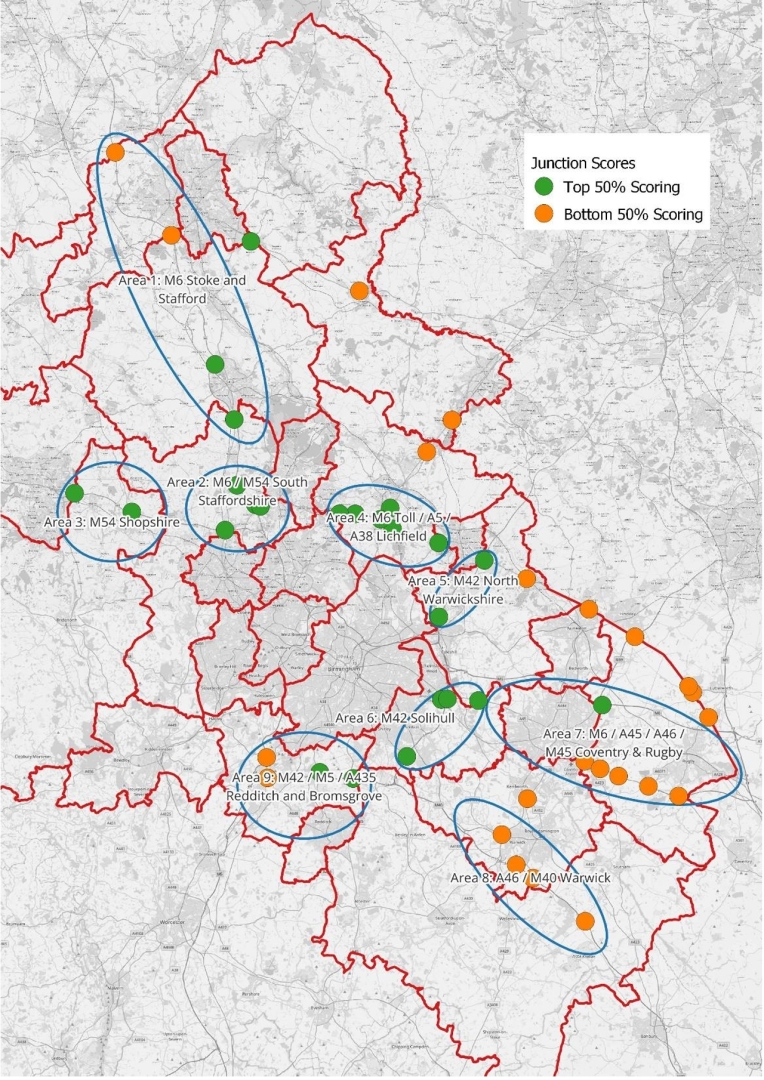
2.5.22 The gross strategic site need for Road Opportunity Area 8 is 225ha, as set out in paragraph 6.58 of the South Warwickshire Employment Land Study Update (2026) which analysed the conclusion of the WMSESS (2024). As this ROA is situated entirely within South Warwickshire, the SWLP fully accommodates this need.
2.5.23 The gross ROA 8 strategic site requirement includes 100ha of existing supply from the Stratford Core Strategy allocated site in Gaydon (Proposal GLH) which is allocated for general industrial development. Accounting for this existing 100ha of supply, left a residual requirement of approximately 75-125ha to be met through the SWLP. The SWLP plans for the upper end of this requirement, as although the WMSESS modelled the 2022-45 period, by planning for the upper end of the requirement it is considered that South Warwickshire’s needs up to 2050 will be met. The site selection process for strategic employment land is set out within the Growth Topic Paper.
2.5.24 As such, Proposal GAY.1 carries forward this 100ha allocation for strategic employment purposes at Gaydon adding an additional 6ha and removing the previous occupier restriction from the allocation. Therefore, the total allocation at GAY.1 - Land to the North of B4100 at Gaydon is 106ha, predominantly for large-scale B2 industrial uses (units over 9,300sqm), with up to 50% of floorspace permitted to be used for advanced-manufacturing related B8 use class units. As such, only 6ha of the proposed allocation counts towards the residual strategic employment requirement. A further 51ha to the south of the existing Jaguar Land Rover site at Gaydon is allocated to allow the further expansion of the automotive sector at this key location in South Warwickshire. Proposal BIT.3 allocates 121ha of land for strategic employment land within use classes B2 and B8 on the northern side of the M40, between the current Junctions 13 and 14. Together these two sites will meet South Warwickshire’s need for strategic employment land, delivering 278ha of strategic employment land, in excess of the identified gross need of 225ha.
2.5.25 In addition, within ROA7 the strategic site commitment of employment land at the ex-Coventry Airport site is allocated for strategic employment uses within the SWLP. This 125ha site (117ha of which is in South Warwickshire) has already been accounted for within the strategic site supply for ROA7 of the West Midlands Strategic Employment Sites Study under its extant planning consent for the development of a Gigafactory – a large-scale battery manufacturing facility (WDC Planning Ref: W/21/1370 and W/25/0265). Whilst delivery of a gigafactory remains the primary objective for the site, it is considered appropriate to broaden the scope of potential uses on site to include other advanced manufacturing activities to afford sufficient flexibility. Full details of this site allocation are included within the separate Proposal COV.2.
2.5.26 Further to the Coventry Airport site, an additional 71.8ha at the Gateway south and 16.3ha at Whitley south sites, south of Coventry is allocated for strategic employment uses (Use Class B2 andB8). These two sites have also already been accounted for within ROA7s strategic site supply within the WMSESS (2024). The HEDNA - WMSESS Alignment Paper Addendum (2025) clarifies that the site area contributing to the strategic employment supply at Gateway South should exclude 90ha dedicated to a Country Park. Gateway South and Whitley South were both allocated as part of a Sub-Regional Employment Allocation within the Warwick District Local Plan (2011-2029). Both sites also benefit from extant Outline Planning Permission. 11ha at Whitley South has also been granted full planning permission.
2.5.27 There is no further need for additional allocations in South Warwickshire in Area 7, as the remaining need as set out in the WMSESS is being addressed in other local authorities.
2.5.28 No sites are proposed for allocation to meet the strategic site need of Road Opportunity Area 9 within the SWLP, as the Districts of Redditch and Bromsgrove - of who Area 9 primarily relates to - have not expressed a desire for Stratford-on-Avon District to accommodate this strategic employment need within our boundaries.
2.5.29 For non-strategic employment needs, the South Warwickshire Employment Land Study Update set out the supply/demand balance for office and local industrial land. This is amalgamated into a single figure for office and local industrial land to allow flexibility to bring forwards office floorspace alongside other forms of employment development. Overall, the evidence identifies a need for just over 320ha (gross) and 233.7ha (net) of non-strategic employment land over the period 2021-2050. This need will be met through a combination of existing employment land commitments and allocations across both districts, as set out in Policies DS.2 and DS.5. The sites identified for allocation for non-strategic employment land will deliver a headroom of approximately 10.48% above identified net need across South Warwickshire.
2.5.30 A 2025 Homes-Jobs Alignment Paper prepared for the authorities in the Coventry and Warwickshire HMA considered the relationship between jobs and homes by comparing potential jobs growth with the growth in labour supply and the likely number of jobs supported by the planned housing delivery. It concluded that there was a broad alignment between homes and jobs in the HMA, and therefore there was no need to plan for a level of housing provision above Local Housing Need. A 2026 update focusing on Homes and Jobs alignment in South Warwickshire reached the same conclusion.
Policy Justification ~ Housing
2.5.31 The Local Housing Need for South Warwickshire is 2,197 dwellings per annum. This was calculated in May 2025 using the Government’s standard method. The Local Housing Need equates to the requirement for each authority over the plan period and are set out in the policy above.
2.5.32 The Councils will publish annual updates of deliverable sites sufficient to demonstrate a 5-year supply of housing against the above annual requirements. Should the circumstances arise where one Council is unable to demonstrate a 5YHLS, this will not affect the land supply calculation result in the other Council. Similarly for the Housing Delivery Test, the two areas will continue to be measured separately, with any policy consequences applying to the individual District where the result is generated.
2.5.33 Dwellings with an existing planning permission at 1st April 2025 are counted as commitments. As these dwellings are built, completions will be subtracted from the overall requirement for the plan period.
2.5.34 A small sites windfall allowance has been added for each Council. This reflects past trends of windfall completions on sites of 1-9 dwellings. The windfall allowance has been applied from year 4 of the plan period onwards to reflect the anticipated time it will take for such sites to deliver new dwellings. The Growth Strategy Topic Paper explains the background to the windfall allowance.
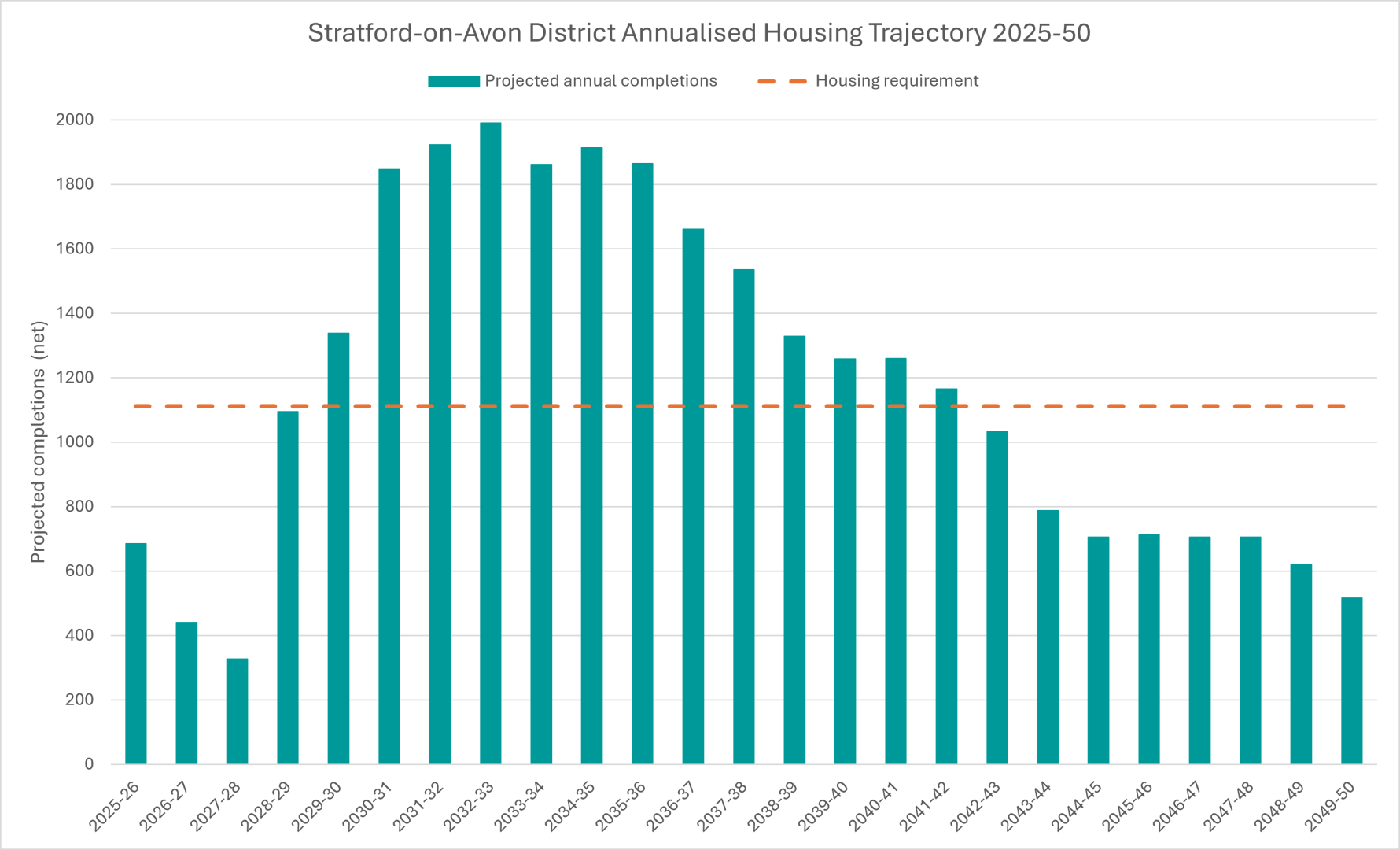
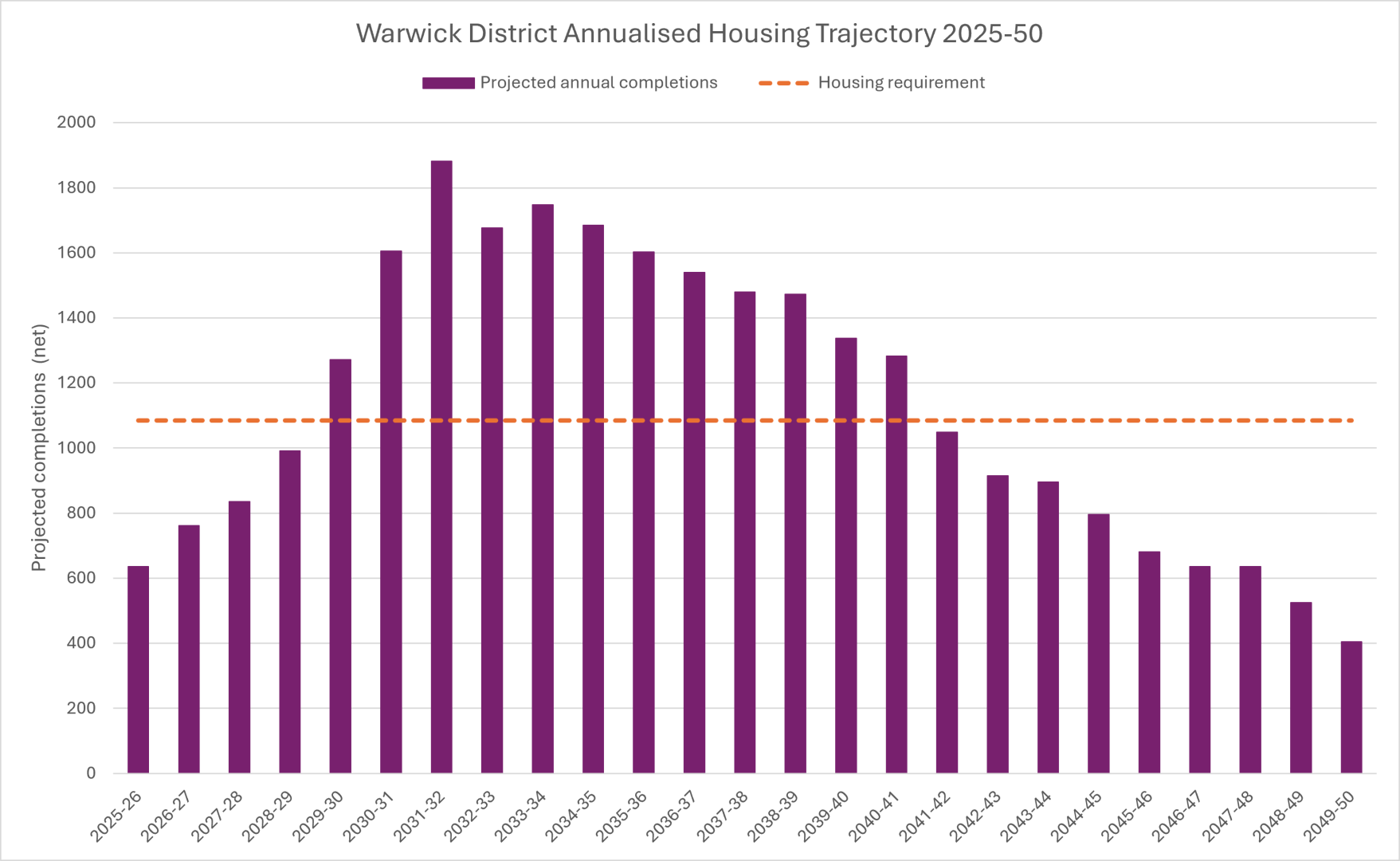
2.5.35 The total number of dwellings to be allocated refers to the totals from the sites identified in policies DS.2 (supported by detailed site-specific policies in Chapter 8) and DS.5, which also include allocations from previous Development Plans that have been rolled forward. These are summarised in the Housing Trajectories for each authority in Figures 14 and 15 below whilst Figures 16 and 17 projected completions against the requirement.
2.5.36 As can be seen, the total identified supply of housing indicates a headroom of 5.3% for Stratford District and 4.4% for Warwick District, equating to an overall headroom of 4.9% in South Warwickshire overall. The SWLP includes separate housing trajectories for the two districts with each district continuing to calculate its own separate 5YHLS. This is considered appropriate given that each district remains a sovereign local planning authority with its own planning committee. As such, additional supply (i.e. headroom) in one district will not contribute towards housing supply in the other district.
2.5.37 An element of contingency is necessary to provide a degree of flexibility above the housing requirement to allow for the potential non-delivery of some sites and to assist the Councils with being able to demonstrate a 5-year housing land supply. In addition to the known commitments at 1st April 2025 and SWLP allocations, both Councils currently have a large number of planning applications for residential-led development pending consideration which, if approved, would yield a significant number of dwellings that could be added to the housing trajectories in due course. It is therefore anticipated that the number of committed dwellings in both Councils will increase substantially in the early part of the plan period, providing additional headroom and flexibility towards achieving a 5-year housing land supply. In recognition of this likely source of additional supply, a modest short-term large sites windfall allowance has been included for both Councils, with the expectation that this delivery will occur in the early part of the plan period.
Policy Justification ~ Gypsy & Travellers, Travelling Showpeople and Boat Dwellers
2.5.37 The requirement for Gypsies & Travellers, Travelling Showpeople and Boat Dwellers is set out in the 2026 South Warwickshire Gypsy and Traveller Accommodation Needs Assessment (GTANA). The GTANA covers the period 2025-2050. As with the housing requirement, each Council has separate requirements and will maintain a separate five-year supply of deliverable traveller sites.
2.5.38 A windfall allowance of two traveller pitches per annum is included for Stratford-on-Avon District as there is consistent evidence of unidentified sites coming forward through the development management process. As per general housing, the windfall allowance has been applied from year 4 of the plan period onwards to reflect the anticipated time it will take for such sites to deliver new authorised pitches. It is assumed that the shortfall of 6 Travelling Showpeople plots within Stratford-on-Avon District will be met by means of windfall applications.
Figure 14: Stratford-on-Avon Housing Trajectory 2025-2050
|
Ref |
Site |
Indicative Capacity |
2025/26 |
2026/27 |
2027/28 |
2028/29 |
2029/30 |
2030/31 |
2031/32 |
2032/33 |
2033/34 |
2034/35 |
2035/36 |
2036/37 |
2037/38 |
2038/39 |
2039/40 |
2040/41 |
2041/42 |
2042/43 |
2043/44 |
2044/45 |
2045/46 |
2046/47 |
2047/48 |
2048/49 |
2049/50 |
|
|---|---|---|---|---|---|---|---|---|---|---|---|---|---|---|---|---|---|---|---|---|---|---|---|---|---|---|---|---|
|
Dwellings with planning permission at 1st April 2025 |
3825 |
685 |
440 |
236 |
412 |
474 |
534 |
447 |
252 |
190 |
105 |
50 |
0 |
0 |
0 |
0 |
0 |
0 |
0 |
0 |
0 |
0 |
0 |
0 |
0 |
0 |
||
|
Windfall Allowance |
3630 |
0 |
0 |
0 |
165 |
165 |
165 |
165 |
165 |
165 |
165 |
165 |
165 |
165 |
165 |
165 |
165 |
165 |
165 |
165 |
165 |
165 |
165 |
165 |
165 |
165 |
||
|
Short-term large sites windfall allowance |
500 |
0 |
0 |
0 |
100 |
100 |
100 |
100 |
100 |
0 |
0 |
0 |
0 |
0 |
0 |
0 |
0 |
0 |
0 |
0 |
0 |
0 |
0 |
0 |
0 |
0 |
||
|
Allocations |
||||||||||||||||||||||||||||
|
New Communities |
||||||||||||||||||||||||||||
|
LMA |
Long Marston Airfield |
4500 |
0 |
0 |
0 |
0 |
0 |
0 |
50 |
100 |
150 |
200 |
250 |
250 |
250 |
250 |
250 |
250 |
250 |
250 |
250 |
250 |
300 |
300 |
300 |
300 |
300 |
|
|
Strategic Growth Locations |
||||||||||||||||||||||||||||
|
BID.1 |
Bidford-on-Avon - Land to North and East |
2225 |
0 |
0 |
0 |
0 |
0 |
0 |
0 |
0 |
30 |
120 |
124 |
150 |
150 |
150 |
150 |
150 |
150 |
150 |
150 |
150 |
150 |
150 |
150 |
100 |
51 |
|
|
HEN |
Henley-in-Arden |
2084 |
0 |
0 |
0 |
0 |
40 |
80 |
120 |
175 |
175 |
175 |
176 |
150 |
150 |
160 |
168 |
135 |
130 |
110 |
83 |
50 |
7 |
0 |
0 |
0 |
0 |
|
|
SOU.1 |
Southam – Land to East |
3122 |
0 |
0 |
0 |
25 |
100 |
190 |
215 |
337 |
335 |
320 |
320 |
300 |
280 |
209 |
160 |
160 |
90 |
60 |
21 |
0 |
0 |
0 |
0 |
0 |
0 |
|
|
STR.1 |
Stratford – Land to North |
777 |
0 |
0 |
0 |
0 |
24 |
30 |
44 |
80 |
130 |
145 |
145 |
119 |
60 |
0 |
0 |
0 |
0 |
0 |
0 |
0 |
0 |
0 |
0 |
0 |
0 |
|
|
STR.2 |
Stratford – Land to South-east |
2727 |
0 |
0 |
0 |
0 |
0 |
30 |
90 |
140 |
170 |
170 |
170 |
170 |
170 |
170 |
215 |
260 |
240 |
198 |
119 |
90 |
90 |
90 |
90 |
55 |
0 |
|
|
STR.3 |
Stratford – Land to West |
687 |
0 |
0 |
10 |
40 |
80 |
115 |
95 |
95 |
95 |
95 |
62 |
0 |
0 |
0 |
0 |
0 |
0 |
0 |
0 |
0 |
0 |
0 |
0 |
0 |
0 |
|
|
WEL.1 |
Wellesbourne North |
1331 |
0 |
0 |
0 |
0 |
0 |
0 |
0 |
0 |
80 |
120 |
150 |
150 |
150 |
150 |
150 |
140 |
140 |
101 |
0 |
0 |
0 |
0 |
0 |
0 |
0 |
|
|
Local Growth Locations |
||||||||||||||||||||||||||||
|
Allocations |
3400 |
0 |
0 |
73 |
310 |
319 |
572 |
542 |
524 |
290 |
239 |
208 |
162 |
116 |
45 |
0 |
0 |
0 |
0 |
0 |
0 |
0 |
0 |
0 |
0 |
0 |
||
|
NDP Allocations (carried forward) |
471 |
0 |
0 |
8 |
43 |
36 |
30 |
56 |
23 |
50 |
60 |
45 |
45 |
45 |
30 |
0 |
0 |
0 |
0 |
0 |
0 |
0 |
0 |
0 |
0 |
0 |
||
|
Totals |
||||||||||||||||||||||||||||
|
Cumulative Stratford housing requirement |
27,800 |
1112 |
2224 |
3336 |
4448 |
5560 |
6672 |
7784 |
8896 |
10008 |
11120 |
12232 |
13344 |
14456 |
15568 |
16680 |
17792 |
18904 |
20016 |
21128 |
22240 |
23352 |
24464 |
25576 |
26688 |
27800 |
||
|
Projected annual completions |
29,279 |
685 |
440 |
327 |
1095 |
1338 |
1846 |
1924 |
1991 |
1860 |
1914 |
1865 |
1661 |
1536 |
1329 |
1258 |
1260 |
1165 |
1034 |
788 |
705 |
712 |
705 |
705 |
620 |
516 |
||
|
Projected cumulative completions |
29,279 |
685 |
1125 |
1452 |
2547 |
3885 |
5731 |
7655 |
9646 |
11506 |
13420 |
15285 |
16946 |
18482 |
19811 |
21069 |
22329 |
23494 |
24528 |
25316 |
26021 |
26733 |
27438 |
28143 |
28763 |
29279 |
||
Figure 15: Warwick Housing Trajectory 2025-2050
|
Ref |
Site |
Indicative Capacity |
2025/26 |
2026/27 |
2027/28 |
2028/29 |
2029/30 |
2030/31 |
2031/32 |
2032/33 |
2033/34 |
2034/35 |
2035/36 |
2036/37 |
2037/38 |
2038/39 |
2039/40 |
2040/41 |
2041/42 |
2042/43 |
2043/44 |
2044/45 |
2045/46 |
2046/47 |
2047/48 |
2048/49 |
2049/50 |
|
|---|---|---|---|---|---|---|---|---|---|---|---|---|---|---|---|---|---|---|---|---|---|---|---|---|---|---|---|---|
|
Dwellings with planning permission at 1st April 2025 |
6149 |
635 |
761 |
768 |
641 |
512 |
371 |
362 |
267 |
245 |
245 |
253 |
210 |
210 |
225 |
225 |
220 |
0 |
0 |
0 |
0 |
0 |
0 |
0 |
0 |
0 |
||
|
Small Sites Windfall Allowance |
1826 |
0 |
0 |
0 |
83 |
83 |
83 |
83 |
83 |
83 |
83 |
83 |
83 |
83 |
83 |
83 |
83 |
83 |
83 |
83 |
83 |
83 |
83 |
83 |
83 |
83 |
||
|
short-term large windfall |
600 |
0 |
0 |
0 |
80 |
80 |
80 |
80 |
80 |
100 |
100 |
0 |
0 |
0 |
0 |
0 |
0 |
0 |
0 |
0 |
0 |
0 |
0 |
0 |
0 |
0 |
||
|
Allocations |
||||||||||||||||||||||||||||
|
New Communities |
||||||||||||||||||||||||||||
|
HAT |
Hatton |
4,000 |
0 |
0 |
0 |
0 |
15 |
50 |
50 |
50 |
105 |
133 |
156 |
187 |
187 |
219 |
240 |
262 |
262 |
262 |
262 |
262 |
262 |
262 |
262 |
262 |
250 |
|
|
Strategic Growth Locations |
||||||||||||||||||||||||||||
|
BIT.1 |
Bishop’s Tachbrook - Land to West |
655 |
0 |
0 |
0 |
0 |
0 |
40 |
80 |
80 |
80 |
80 |
80 |
80 |
80 |
55 |
0 |
0 |
0 |
0 |
0 |
0 |
0 |
0 |
0 |
0 |
0 |
|
|
BIT.3 |
Bishop’s Tachbrook - Land North West |
1720 |
0 |
0 |
0 |
25 |
50 |
70 |
130 |
139 |
130 |
170 |
170 |
170 |
166 |
140 |
120 |
120 |
80 |
40 |
0 |
0 |
0 |
0 |
0 |
0 |
0 |
|
|
COV.1 |
South of Coventry |
4015 |
0 |
0 |
0 |
0 |
40 |
55 |
144 |
175 |
189 |
250 |
270 |
370 |
434 |
430 |
389 |
270 |
232 |
100 |
140 |
126 |
80 |
80 |
80 |
90 |
71 |
|
|
COV.3 |
South of Coventry - Kings Hill[6] |
1500 |
0 |
0 |
0 |
0 |
0 |
0 |
0 |
0 |
0 |
0 |
0 |
0 |
0 |
0 |
0 |
50 |
100 |
210 |
210 |
210 |
210 |
210 |
210 |
90 |
0 |
|
|
KEN.1 |
Kenilworth - Land to South |
776 |
0 |
0 |
0 |
0 |
40 |
90 |
140 |
140 |
106 |
100 |
90 |
60 |
0 |
0 |
0 |
0 |
0 |
0 |
0 |
0 |
0 |
0 |
0 |
0 |
0 |
|
|
LEA.1 |
Leamington Spa - Land to North (Blackdown) |
1043 |
0 |
0 |
0 |
0 |
0 |
55 |
100 |
100 |
100 |
100 |
100 |
100 |
100 |
100 |
60 |
57 |
71 |
0 |
0 |
0 |
0 |
0 |
0 |
0 |
0 |
|
|
LEA.2 |
Leamington Spa - Land to North (Milverton) |
974 |
0 |
0 |
0 |
0 |
0 |
0 |
0 |
40 |
80 |
95 |
100 |
80 |
80 |
80 |
80 |
80 |
80 |
80 |
60 |
39 |
0 |
0 |
0 |
0 |
0 |
|
|
LEA.3 |
Leamington Spa - Land to East (Lillington) |
1455 |
0 |
0 |
0 |
0 |
0 |
40 |
130 |
140 |
140 |
140 |
140 |
140 |
80 |
80 |
80 |
80 |
80 |
80 |
80 |
25 |
0 |
0 |
0 |
0 |
0 |
|
|
WAR.1 |
Warwick - Land to West |
850 |
0 |
0 |
0 |
0 |
0 |
0 |
45 |
50 |
60 |
60 |
60 |
60 |
60 |
60 |
60 |
60 |
60 |
60 |
60 |
50 |
45 |
0 |
0 |
0 |
0 |
|
|
Local Growth Locations |
||||||||||||||||||||||||||||
|
Allocations |
1461 |
0 |
0 |
18 |
47 |
401 |
422 |
307 |
132 |
106 |
28 |
0 |
0 |
0 |
0 |
0 |
0 |
0 |
0 |
0 |
0 |
0 |
0 |
0 |
0 |
0 |
||
|
Warwick Local Plan Allocations (carried forward) |
1307 |
0 |
0 |
50 |
115 |
50 |
249 |
230 |
190 |
223 |
100 |
100 |
0 |
0 |
0 |
0 |
0 |
0 |
0 |
0 |
0 |
0 |
0 |
0 |
0 |
0 |
||
|
Totals |
||||||||||||||||||||||||||||
|
Cumulative Warwick housing requirement (1,085 dpa) |
27,125 |
1085 |
2170 |
3255 |
4340 |
5425 |
6510 |
7595 |
8680 |
9765 |
10850 |
11935 |
13020 |
14105 |
15190 |
16275 |
17360 |
18445 |
19530 |
20615 |
21700 |
22785 |
23870 |
24955 |
26040 |
27125 |
||
|
Projected annual completions |
28,331 |
635 |
761 |
836 |
991 |
1271 |
1605 |
1881 |
1676 |
1747 |
1684 |
1602 |
1540 |
1480 |
1472 |
1337 |
1282 |
1048 |
915 |
895 |
795 |
680 |
635 |
635 |
525 |
404 |
||
|
Projected cumulative completions |
28,331 |
635 |
1396 |
2231 |
3222 |
4493 |
6098 |
7979 |
9655 |
11402 |
13086 |
14688 |
16228 |
17708 |
19180 |
20517 |
21799 |
22847 |
23762 |
24657 |
25452 |
26132 |
26767 |
27402 |
27927 |
28331 |
||
2.6 Strategic Site Principles
Policies within this section contribute to achieving the following Strategic Objectives:
SO1. Providing infrastructure in the right place at the right time
SO2. Delivering homes that meet the needs of all our communities
SO3. Developing opportunities for jobs and growing the economy
SO4. Making effective use of land and natural resources
SO6. Creating attractive places and spaces
SO7. Protecting and enhancing our heritage and cultural assets
SO8. Improving the quality of life of our communities
SO9. Connecting people to places
SO10. Conserving and enhancing our environmental assets and working towards environmental net gain
2.6.1 The Strategic Growth Locations are identified in Policy DS.2 above. To ensure their timely delivery and a cohesive and comprehensive approach to community creation, Policy DS.4 sets out the key principles that these sites will comply with.
Policy DS.4 (Strategic Policy)
Strategic Site Principles
The bulk of new development across South Warwickshire to 2050 will be provided at New Settlements and Strategic Growth Locations (SGLs) to meet our development needs in accordance with Policies DS.2 and DS.3. The housing numbers expressed in Policies DS.3, DS.6 and DS.7 and the relevant Site Proposals are minimum figures and may be exceeded if good planning outcomes can be secured, including for example through the application of increased densities.
A. Overarching Principles
All New Settlements and Strategic Growth Locations are required to adhere to the following overarching principles:
- Respond positively to their existing setting, ensuring that development is landscape-led and informed by a thorough assessment of existing constraints and opportunities. Proposals must demonstrate how the development relates to the existing urban form (where applicable) and must be of high quality in terms of design, through consideration of key views, landscape setting and heritage assets.
- Achieve appropriate residential densities that make efficient use of land while respecting local character. Development layouts must prioritise pedestrian and cycle connectivity both within the site and to existing settlements and key destinations beyond the site boundary.
- Make provision for pitches, plots or moorings to accommodate the needs of Gypsies & Travellers, Travelling Showpeople and Boat Dwellers.
B. Infrastructure
All New Settlements and Strategic Growth Locations must be delivered with regard to the Infrastructure Delivery Plan (IDP), providing an appropriate mix of uses, infrastructure and community facilities that are well located to support walkable twenty-minute neighbourhoods[7]. The timing and phasing of mixed-use components in development proposals, and of key infrastructure, must ensure that new communities are supported by facilities as development progresses.
To facilitate this, New Settlements and SGLs are expected to:
- Prepare an agreed masterplan with the LPA prior to the submission of any planning application. The masterplan will be expected to be agreed between all promoters, landowners and developers as applicable and should be informed by engagement with residents and relevant consultees. These masterplans will set out a clear timetable for phasing and the delivery of infrastructure and community facilities.
- Ensure the early delivery of infrastructure, including roads, healthcare facilities, utilities and schools prior to, or alongside, occupation by future residents. Development proposals must identify clear trigger points for the delivery of key infrastructure in any overall phasing plan. The use of temporary facilities should be considered to help meet the needs of early occupants of the development.
- Ensure that clear mechanisms are in place regarding developer contributions towards site wide infrastructure as identified in the IDP. Planning applications must be accompanied by viability assessments demonstrating deliverability of required infrastructure. Contributions must be secured through S106 agreements or other appropriate legal mechanisms.
- Create twenty-minute neighbourhoods through the prioritisation of public transport alongside active travel infrastructure, enabling connection to the surrounding area. This also means ensuring that development is served by a range of services and facilities, sufficient to meet the day-to-day needs of residents within reasonable walking distance.
C. Affordable Housing Provision
Affordable housing will be provided on the housing-led strategic sites in accordance with Policy HO.3. Acknowledging the current mixed viability picture, consideration will be given to a range of mechanisms to assist with maximising the delivery of affordable housing on these sites.
D. Accommodation for the Traveller Community
New settlements and Strategic Growth Locations will be required to deliver Gypsy and Traveller sites and Travelling Showpeople yards in accordance with the Site Proposals set out in Chapter 8. In doing so, the following criteria will apply:
- The provision of pitches and plots on strategic growth locations should be agreed from the outset as part of the masterplanning process and must only be provided in parts of the site which would be suitable for any other form of housing. The concept masterplan prepared for each of these locations includes a broad location that is considered as suitable for the provision of pitches/plots.
- The pitches/plots will be provided by the developer themselves or where the land is transferred for a nominal value, by an agreed third-party Registered Provider or other agreed private provider, for the sole purpose of occupation by Gypsy’s and Travellers and Travelling Showpeople.
- The pitches/plots must be provided and made available for occupation before the occupation of a specified proportion of the provision of on-site open market dwellings.
- Gypsy and traveller pitches and travelling showpersons plots must be provided at the locations specified above unless it can be demonstrated that an alternative off-site provision will achieve an equitable or better living environment at a sustainable location. Any off -site provision must ensure that at least the same number of pitches/plots are provided and within an agreed timescale in accordance with criterion 3.
E. Delivery and Stewardship
All New Settlements and Strategic Growth Locations must:
- Be accompanied by a Development Strategy submitted as part of the initial application that demonstrates how development will come forward in a co-ordinated manner, consistent with the principles of the master developer approach.
- Delivery will be co-ordinated by a Site Delivery Officer and overseen by a Delivery Board, supported by a Community Champion to facilitate community development on site and provide a point of contact for residents.
- Promote effective long-term stewardship of community assets and green infrastructure through the establishment of appropriate management agreements with parish or town councils, community trusts, resident’s associations or the relevant Local Planning Authority. Details of provision are to be agreed during the masterplanning process ahead of any initial planning permission.
DS.4 ~ Development Management Considerations
In relation to Part B ~ Given the length of time over which these sites will be developed, a vision-led, key objectives and masterplan approach is encouraged. Agreeing and committing to the vision and key principles from the outset provides flexibility to amend the masterplan should circumstances change such as changes to policy, building regulations, technology or markets, for example.
In relation to Part C ~ measures to maximise affordable housing provision may include:
- Working with site promoters to help secure infrastructure/affordable housing grants and/or loans
- Backloading or reprofiling of affordable housing requirements
- Clawback mechanism where a lower affordable housing requirement is agreed
- LPA providing forward-funding of infrastructure provision
- Alterations to the housing size and tenure mix
- Partial off-site commuted sum provision
Consideration of the above is dependent upon submission of a robust viability appraisal that will be assessed and verified by independent viability expert consultants.
In relation to Part D ~ A clear mechanism to ensure that pitches and plots are delivered in such a way as to achieve a good living environment at a sustainable location must be identified. This will be through a s106 agreement requiring the developer to identify and obtain planning permission for the required number and standard of pitches/plots. Conditions will also be imposed regulating the occupancy of the plots to ensure that the occupants meet the definition of Gypsy and Travellers and Travelling Showpeople within PPTS. The marketing arrangements and cost of pitches will be addressed via conditions and /or a s.106 agreement.
Policy Justification
2.6.2 New strategic-scale allocations, through either New Settlements or Strategic Growth Locations (SGLs), will play a key role in delivering the spatial growth strategy of the South Warwickshire Local Plan. Strategic allocations are located within the Priority Areas, which emphasises the sustainable use of land, including the use of Brownfield Land for Development.
2.6.3 Given the length of the plan period, due consideration should also be given to the latest version of the NPPF or its successor when preparing planning applications. To ensure development responds to its specific location, each New Settlement and SGL is supported by a site-specific policy. These individual policies set detailed requirements for design principles and infrastructure provision that are directly applicable to the local context and the needs of both new and existing residents.
2.6.4 New Settlements, which are larger and intended to provide the foundation for growth beyond 2050, are the focal point for the delivery of housing growth in the South Warwickshire Local Plan. Given their scale, New Settlements are required to deliver comprehensive on-site infrastructure to serve the needs of residents, including education, healthcare, employment, retail and community facilities. New Settlements must be landscape-led in terms of their approach to design, establishing a distinct identity while integrating sensitively with the landscape, taking into account its existing character and form. SGLs are typically smaller in scale, and act as extensions to existing settlements in South Warwickshire. This proximity means that they are required to enhance existing infrastructure and services, ensuring that development is designed to integrate effectively for both new and existing residents.
2.6.5 New Settlements and SGLs in the SWLP are defined by a red-line boundary, which identifies the policy allocation area where development is acceptable in principle. These strategic scale developments are intended to be large enough to provide key on-site infrastructure to mitigate adverse effects and meet the needs of both new and existing residents as they arise. New Settlements will deliver at least 4,000 homes, though it is accepted that some of this will come forward outside of the plan period. SGLs typically exceed 1,000 dwellings or 25ha of employment land.
2.6.6 The infrastructure required for each site is identified within the relevant Site Proposals set out in Chapter 8 and listed in the Infrastructure Delivery Plan (IDP), which is critical in ensuring that the plan is sound. The IDP sets out the type, scale and timing of infrastructure needed to support each New Settlement and SGLs. This includes transport improvements, education facilities, healthcare provision, utilities and community facilities. Development proposals must have regard to the infrastructure requirements identified in the IDP and demonstrate how these will be delivered in a timely manner to support new residents.
2.6.7 All New Settlements and SGLs must be informed by a comprehensive strategic masterplan agreed by the Local Planning Authority, which should be prepared and approved prior to the submission of any planning application. Such masterplans may be formally adopted as Supplementary Plans. These masterplans should be based on the concept masterplans contained within the SWLP which establish the key principles that need to be met and form the spatial basis for the site proposal itself. Significant departure from the concept masterplan will need to be fully justified. Mindful of the need to delivery communities at pace, the intention is not to sow-down the delivery process. As such, the LPA will work proactively with site promoters to assist in delivery of the masterplans. Indeed, the purpose of the masterplan is not to agree every detail – this would be impractical for sites that will be built out over a number of decades - but to establish a framework that provides a robust mechanism to ensure (a) a comprehensive approach to development and (b) that the community and the LPA has the certainty that infrastructure that is required will be delivered.
2.6.8 This masterplanning process is the primary vehicle for demonstrating how the development will meet the policy's specific design requirements, including a landscape-led approach that integrates new green and blue infrastructure from the outset. The masterplan must provide a clear framework for a permeable network that prioritises walking, cycling and public transport to support the creation of a walkable 20-minute neighbourhood. Subsequent planning applications must comply with these agreed documents, ensuring that the hierarchy of public spaces, efficient densities and low-carbon design standards are secured through conditions and legal agreements.
2.6.9 The masterplan must set out a comprehensive strategy for how infrastructure will be delivered on site, with phasing agreed that clearly identifies trigger points over the period of expected delivery. Infrastructure must be delivered prior to or in line with the residential occupation and must not be delivered after need arises. Any phasing strategy should also demonstrate how different land uses will be integrated between different land parcels to create mixed-use sustainable communities rather than.
2.6.10 Travelling is an integral part of the cultural identity for Gypsy and Traveller and Travelling Showpeople households. It is legally accepted that nomadism, and living in a caravan, reflects the cultural heritage of such families, not simply a lifestyle choice. Gypsies and Travellers are recognised ethnic groups and are entitled to the same access to housing as the settled community. Often in a cycle of ‘enforced’ nomadism, being continually moved on by the authorities because of the shortage of authorised sites, means they are often more disadvantaged than any other ethnic group in terms of access to healthcare and education.
2.6.11 The cultural practice of Travelling Showpeople is to live on a plot in a yard in static caravans or mobile homes, along with smaller caravans used for travelling or inhabited by other family members. Their equipment (including rides, kiosks and stalls) is usually kept on the same plot. Clearly, such large storage and maintenance areas have implications in terms the design of plots. Residential amenity and landscape impact will require very careful consideration when devising site layouts.
2.6.12 Due to the particular lifestyle and accommodation requirements of travelling showpeople it is important to ensure that they are provided safe, well designed and appropriately sized accommodation. To enable the necessary storage and circulation of associated equipment the policy has identified Strategic growth locations where large-scale employment development is intended as the most appropriate location for new travelling showpeople yards. It will be necessary to ensure that the Travelling Showpeople families are provided with well-designed accommodation that will meet their particular needs whilst also ensuring a good standard of residential amenity.
2.6.13 Strategic employment locations will have good access to the main highway network which will enable the safe circulation and transportation of infrastructure associated with Travelling Showpeople.
2.6.14 The provision of pitches within strategic development locations is considered to be an effective and sustainable mechanism as part of this Plan’s overall strategy for providing new traveller accommodation. It will ensure that the occupants have good access to facilities and be able to integrate with the settled community.
2.6.15 In some cases, the Councils may accept evidence that a particular use is not viable until a certain level of occupancy is achieved. However, this must be demonstrated through the viability assessment that is agreed with by all parties through the masterplan process, with updates made to any phasing strategy. The introduction of a site wide master developer may be beneficial in ensuring effective and co-ordinated delivery across complex multi-ownership sites. Where it is considered that the required level of infrastructure has changed following the adoption of the Local Plan, the Councils expect to receive a full submission of technical evidence, including a viability statement setting out the reasons for these change
2.6.16 Developer contributions towards site wide infrastructure will be secured through section 106 agreements or other appropriate legal mechanisms. All planning applications must be accompanied by a viability assessment that demonstrates the deliverability of required infrastructure identified in the IDP. The councils will work with developers to ensure that contribution mechanisms are clear, fair, and enforceable.
2.6.17 Experience of delivering large-scale developments under the previous Local Plans has confirmed that a co-ordinated approach to delivery is required and that new communities require assistance to help establish and bed them in. Delivery Boards will ensure democratic oversight and in addition to representatives from the Local Planning Authority, would include representatives of the site promoters.
2.6.18 Long term stewardship and management of community assets such as public open space and areas of biodiversity is essential to maintaining the quality and functionality of new developments for future generations. Applicants must establish appropriate mechanisms for management arrangements as part of the masterplanning process, these arrangements would see the transfer of these assets to parish and town councils, community trusts, local planning authorities. These arrangements must be agreed with the Local Planning Authority and secured through legal agreements prior to the first occupation.
2.7 Local Growth Locations
Policies within this section contribute to achieving the following Strategic Objectives:
SO2. Delivering homes that meet the needs of all our communities
SO3. Developing opportunities for jobs and growing the economy
SO4. Making effective use of land and natural resources
SO5. Contributing towards Net Zero Carbon targets
SO6. Creating attractive places and spaces
SO8. Improving the quality of life of our communities
SO9. Connecting people to places
SO10. Protecting and enhancing our environmental assets and working towards environmental net gain
2.7.1 In accordance with Policy DS.2, the following policies set out the various non-strategic employment (Policy DS.5), mixed-use, leisure, community and town centre (Policy DS.6) and housing (DS.7) allocations that will be delivered by 2050 to meet local needs. These include sites identified through the SWLP in accordance with the spatial strategy and priority areas (see above) as well as sites identified in previous local and neighbourhood plans that are considered suitable to be carried over into the SWLP.
2.7.2 Policy DS.5 includes employment provision that meets local needs although these sites are to be delivered at the Strategic Growth Locations.
2.7.3 For reference, a consolidated list of allocations by settlement is included in Appendix 2. This also includes any previous or alternative site reference, such as that used in a Neighbourhood Plan or as used in the Housing and Employment Land Availability Assessment (HELAA).
Policy DS.5 Local Growth Locations ~ Employment (Strategic Policy)
A. New Allocations
|
Site Reference and name |
CFS Ref |
Site Ref |
Proposal |
Size (ha)(net) |
Specific Site Requirements |
|
|
Bidford-on-Avon East & North |
BID.1a |
Use Class B2, Use Class B8 and Use Class E(g) uses. |
11 |
|
||
|
Henley Golf Club, Henley-in-Arden |
HEN.1a |
3.3ha of land to develop a research and innovation campus in Use Class E(g)(i/ii) uses (office/research and development uses) |
3.3 |
|
||
|
Paradise, Lighthorne Heath |
657 |
GAY.4 |
3ha of employment land in Use Class B2 (general industrial) and Use Class E(g) uses (office/research and development/light industrial uses). |
3 |
|
|
|
Land to the west of JLR, Gaydon |
676 |
GAY.6 |
73.5ha of land for testing tracks only. Site does not contribute to employment requirements due to nature of proposed development. |
73.5 |
|
|
|
Land off Princes Drive, Kenilworth |
54 |
KEN.6 |
Use Class B2, Use Class B8 and Use Class E(g) uses. Smaller units to support SMEs (less than 2,000 sqm) will be particularly encouraged. |
0.6 |
|
|
|
Long Marston New Settlement (additional land). |
LMA.a |
Refer to Proposal LMA- Long Marston New Community. |
7 |
|
||
|
Land South of Leamington Road, Southam |
301 |
SOU.2 |
Use Class B2, Use Class B8 and Use Class E(g) uses. |
5 |
|
|
|
Land at Welsh Road and Daventry Road, Southam |
135 |
SOU.3 |
Use Class B2, Use Class B8 and Use Class E(g) uses. |
2.8 |
|
|
|
Kingswood Business Park, Stoneleigh |
99 |
STO.1 |
Use Class B2, Use Class B8 and Use Class E(g)(iii) uses and ancillary E(g)(i) and (ii) uses. |
64.9 |
|
|
|
Land east of A46, Stoneleigh |
366 |
STO.2 |
Use Class B2, Use Class B8 and Use Class E(g)(iii) uses and ancillary E(g)(i) and (ii) uses. |
12 |
|
|
|
Stoneleigh Park Stoneleigh |
100 |
STO.3 |
Use Class B2, Use Class B8 and Use Class E(g) uses (Intensification of existing site) |
5.4 |
|
|
|
Atherstone Airfield |
979 |
STR.10 |
28ha of additional land at Atherstone Airfield for Use Class B2, Use Class B8 and Use Class E(g) uses. |
28 |
|
|
|
Land adjacent to Jill Lane, Studley |
985 |
STU.5 |
Use Class B2, Use Class B8 and Use Class E(g) uses |
6.5 |
|
|
|
Land at Stratford Road, Warwick |
189 |
WAR.5 |
Use Class B2, Use Class B8 and Use Class E(g). Small and medium size units (less than 9,300sqm) will be particularly supported to complement the allocated site further south of the water treatment works. |
3.9 |
|
|
|
Land East of M40 J15, Longbridge, Warwick |
180 |
WAR.6 |
Use Class B2, Use Class B8 and Use Class E(g) uses. |
12.8 |
|
|
|
Wellesbourne Campus, Wellesbourne |
498 |
WEL.5 |
47.5ha (27ha net of undeveloped land)within the Concept Masterplan area for new development primarily in use classes E(g)(i)(offices) and E(g)(ii) (research and development) and other uses as appropriate to support these, in accordance with the Wellesbourne Campus Concept Masterplan |
27 |
|
|
|
Wellesbourne Airfield, Wellesbourne |
188 |
WEL.6 |
The aviation function of the airfield will be safeguarded in accordance with the Memorandums of Understanding signed August 2019 and August 2022. Proposals for development associated with aviation activity requiring planning permission will be permitted subject to them not having an unacceptable effect on the environment of adjacent areas and on local residents and businesses. The eastern part of the existing Airfield (as shown on the Policies map) will be repurposed for up to 65ha of employment in Use Class B2 (general industrial) and Use Class B8 (storage and distribution) as well as ancillary Use Class E(g) (office/research and development/light industrial) uses, in accordance with the signed Memorandum of Understanding 2022. subject to evidence that the continued operational viability of the Airfield will be maintained and that the employment development proposed would specifically enable the relocation of the runway and the establishment of a more viable airport on a smaller footprint. |
65 |
|
|
B. Allocations Carried Forward
|
Site Reference and name |
CFS Ref |
Site Ref |
Proposal |
Size |
Specific Site Requirements |
|
|
Land at Gaydon/Lighthorne Heath |
GAY.7 |
Use Class B2 (general industrial) and Use Class E(g) uses (office/research and development/light industrial uses). |
4.5 |
|
||
|
Land at Thickthorn, Kenilworth |
KEN.3 |
Use Class B2 and Use Class E(g) employment development |
8 |
|||
|
Long Marston New Settlement |
LMA.b |
Refer to Policy LMA- Long Marston New Settlement. |
8 |
|
||
|
West of Banbury Road. Southam |
SOU.4 |
Use Class B2, Use Class B8 and Use Class E(g) employment development |
1.58 |
|||
|
South of Alcester Road Stratford-upon-Avon |
458 |
STR.3a |
Employment site with ancillary uses (Use Classes B1a, B1b, B1c, B2, B8, A1 and Sui Generis) |
25 |
|
|
|
Atherstone Airfield |
STR.11 |
Use Class B2, Use Class B8 and Use Class E(g) employment development |
19 |
|
||
|
Land at Stratford Road, Warwick (northern part) |
WAR.14 |
Use Class B2, Use Class B8 and Use Class E(g) employment development |
11.7 |
|||
Policy DS.6 Local Growth locations ~ Mixed-use, Leisure, Community and Town Centre (Strategic Policy)
|
Site |
CFS Ref |
Ref |
Proposal |
Size (ha) |
Specific Site Requirements |
|
|
Tachbrook Country Park, Bishop’s Tachbrook |
BIS.4 |
Land adjoining the Tach Brook at Bishop’s Tachbrook |
The park will be a multifunctional green infrastructure asset, designed to:
|
|||
|
University of Warwick Main Campus, South of Coventry |
227 (Part of) |
COV.6 |
62ha of land at the existing University of Warwick Main Campus is safeguarded for education and research and development related uses, in accordance with the Concept Masterplan |
62 |
Future development of this site should be in accordance with this Concept Masterplan. Proposals not addressed by the Masterplan will be considered on their merits and assessed against all other relevant development plan policies. Proposals will be viewed positively where they help contribute to the University delivering a world-class educational campus with the necessary supporting facilities. |
|
|
Meon Vale Local Green Spaces |
MEO.3 |
Designation of Local Green Spaces within Meon Vale |
||||
|
Chandos Street, Leamington Spa |
769 |
LEA.8 |
Focus of a town centre development proposal to comprise of appropriate main town centre uses. |
|
||
|
Althorpe Street, Leamington Spa |
LEA.9 |
Site to be safeguarded for town centre employment uses (Use Class E(g)) |
1.5 |
|||
|
Hamilton Terrace, Brandon Parade and Holly Walk, Leamington Spa |
LEA.10 |
Site to be safeguarded for town centre employment uses (Use Class E(g)) |
5.3 |
|||
|
Stratford-upon-Avon Gateway, Stratford-upon-Avon |
986 |
STR.8 |
Redevelopment of the site for a range of appropriate uses that include:
|
2.04 |
Development of the site should be in accordance with the Land Use and Urban Form Principles Plan and the Heights and Massing Plan shown in Section 8.21. Specific requirements for development of the site include the following:
|
|
|
Rother Quarter, Stratford-upon-Avon |
847 |
STR.9 |
Retention of existing activities appropriate and the redevelopment of specific parts of the site for a range of appropriate uses that could include:
|
2.4 |
|
|
|
Studley Centre, Studley |
986 |
STU.4 |
Public space to act as new village centre supported by a mix of uses including offices, retail, community, health and residential units and open space. |
1.0 |
|
|
|
Barrack St and Northgate St, Warwick |
WAR.13 |
Site to be safeguarded for town centre employment uses (Use Class E(g)) |
1.5 |
|||
|
Myton Community Stadium, Warwick |
WAR.2 |
Community Stadium, including football stadium for Leamington Town FC, relocated athletics facility, education, a neighbourhood centre and other uses. |
||||
|
St Mary Lands, Warwick |
WAR.3 |
To manage, enhance and promote the landscape character of St. Mary's Lands, including increasing its biodiversity To manage, enhance and promote St. Mary's Lands as a green space distinctly different to the more formal parks and open spaces in Warwick, ensuring access is maintained and enhanced to a large area of more natural open space within walking distance of the town centre To promote St. Mary's Lands as a visitor destination, where any such increase in visitor numbers are compatible with preserving and protecting the site's landscape quality, biodiversity and sense of place To support the many organisations that contribute to the broader community needs or local economy, where such support does not lead to a loss of landscape quality, biodiversity or sense of place |
||||
|
Warwick Café Quarter, Warwick |
WAR.4 |
Changes of Use to restaurants and cafes, or drinking establishments will be supported |
||||
Policy DS.7 Local Growth Locations ~ Housing (Strategic Policy)
A. SWLP General Housing Sites
|
SWLP Ref |
Settlement |
CfS Ref |
Site |
Indicative Minimum Capacity |
Specific Site Requirements |
|
ALC.1 |
Alcester |
445 |
Land South of Allimore Lane |
286 |
Careful consideration of landscape sensitivity identified in Alcester NDP required. Developable area of the site must not encroach into areas of Flood Zone 2 or 3. |
|
ALC.2 |
Alcester |
474 |
Land to North of Captains Hill |
79 |
Site considered to be grey belt, development proposals must comply with the NPPF regarding the development of grey belt sites. Careful consideration required to ensure that there is continued public recreational access through open space provision and retained ecological features. |
|
BAR.1 |
Barford |
75 |
Land South of Westham Lane |
34 |
Areas of mature hedgerow and tree cover along the western boundary to be retained. |
|
BAR.2 |
Barford |
172 |
Land East of Wellesbourne Road |
122 |
Sensitive arrangement of development required due to the proximity of minerals allocation at Wasperton Hill Harm. |
|
BII.1 |
Bishop’s Itchington |
371 |
Dadglow Farm (West |
99 |
Sensitive landscaping required to limit development impacts to the south and east. |
|
BII.2 |
Bishop’s Itchington |
143 |
Land West of Butchers Close |
16 |
Access required from the north via Station Road. |
|
GAY.2 |
Gaydon |
40 |
Land off Edgehill View, Kineton Road |
23 |
Developable area must not encroach into areas of surface water flood risk. |
|
GAY.3 |
Gaydon |
444 |
Land at Old Town |
93 |
Development must consider the role of the site in relation to the settlement of Gaydon and reduce developable area accordingly to reflect existing settlement pattern. |
|
GAY.8 |
Gaydon |
264 |
Land South West of Warwick Road |
264 |
Sensitive consideration of development location adjacent to employment land required, with appropriate mitigation of any noise impacts demonstrated as part of a future planning application. |
|
GAY.9 |
Gaydon |
265 |
Land N of Manor Farm, Kineton Road |
Sensitive consideration of development location adjacent to employment land required, with appropriate mitigation of any noise impacts demonstrated as part of a future planning application. |
|
|
GAY.10 |
Gaydon |
271 |
Land East of Banbury Road |
21 |
|
|
HAM.1 |
Hampton Magna |
95 |
Land at Old Budbrooke Road |
250 |
Site considered to be grey belt, development proposals must comply with the NPPF regarding the development of grey belt sites. Developable area must not encroach into areas of surface water flood risk. Important that development proposals consider joint infrastructure requirements alongside HAM.1/Site 55: Land South of Chichester Lane. Development proposals will be required to contribute to the West of Warwick Sustainable Transport Corridor improving connections to Warwick via Warwick Parkway in accordance with SWLP Policy ID.5. |
|
HAR.1 |
Harbury |
341 |
Land off Bush Heath Lane and Temple End |
120 |
Preferred approach is for both land parcels to come forward separately through distinct applications. |
|
HAR.2 |
Harbury |
943 |
Land North of Chesterton Road/Temple End |
20 |
|
|
HAR.3 |
Harbury |
949 |
Land West of Bush Heath Road |
102 |
Pedestrian improvements required on Bush Heath Road. Pedestrian access to recreation ground would be favourable. |
|
Gay |
Kenilworth |
236 |
Land at Crewe Lane |
12 |
Site considered to be grey belt, development proposals must comply with the NPPF regarding the development of grey belt sites. Mature woodland adjacent to Crewe Lane must be retained. |
|
KEN.5 |
Kenilworth |
607 |
Land adjacent to Dale House Lane |
81 |
Site considered to be grey belt, development proposals must comply with the NPPF regarding the development of grey belt sites. Mature woodland and hedgerows to be retained, preserving the character of Dalehouse Lane as an approach to Kenilworth. Development proposals will be required to contribute to the South of Coventry Sustainable Transport Corridor improving connections to Coventry and Royal Leamington Spa in accordance with SWLP Policy ID.5. |
|
KIN.2 |
Kineton |
324 |
Land East of Lighthorne Road |
70 |
Sensitive masterplanning required to ensure areas of woodland to the south are retained. Through access to the village required with active travel links. Explore options for masterplan to include future link road if required by the Local Highways Authority. |
|
KIN.3 |
Kineton |
443 |
Banbury Road |
50 |
Relationship with the historic Battle of Edgehill registered battlefield must be carefully considered, with its inherent historic value and character retained. Strengthened site boundary required to screen development from surrounding landscape. Consideration of relationship with Kineton High School required. Developable area must not encroach into areas of surface water flood risk. |
|
KIN.4 |
Kineton |
470 |
Land North of Banbury Road |
58 |
Relationship with the historic Battle of Edgehill registered battlefield must be carefully considered, with its inherent historic value and character retained. Developable area must not encroach into areas of surface water flood risk. Opportunities to be explored for bringing forward a habitat creation zone adjacent to development utilising blue line land in the landowner’s control. |
|
LEA.4 |
Leamington |
806 |
Covent Garden Car Park, Russell Street |
200 |
Capacity is indicative, however given urban location it is vital that scheme is high density and maximises land use. |
|
LEA.5 |
Leamington |
870 |
Edmonscote Manor, Warwick New Road |
78 |
Development must consider areas of Flood Zone 2 and 3 and be adjusted accordingly, ensuring that proposals do not worsen flood risk elsewhere. |
|
LEA.6 |
Leamington |
96 |
Land at Guy Street / Warwick Street and Parade |
100 |
Capacity is indicative, however given urban location it is vital that scheme is high density and maximises land use. |
|
LIG.1 |
Lighthorne |
386 |
Land to West of Oberry Fields (South) |
18 |
Opportunities available to explore the creation of a new nature reserve or wildlife site on land adjacent to the site. |
|
LMV.1 |
Long Marston |
372 |
Land North of Barley Fields |
14 |
Proposals must consider their landscape visual sensitivity relative to the existing settlement, providing mitigation through a landscape-led approach. Developable area must not encroach into areas of surface water flood risk. |
|
LMV.2 |
Long Marston |
601 |
Glebe Land |
22 |
Development proposals must consider relationship with LMV.3/Site 840: East of Welford Road, exploring opportunities for joint infrastructure provision and arrangement as applicable. Proposals must account for their landscape visual sensitivity relative to the existing settlement, providing mitigation through a landscape led approach. The developable area must not encroach into areas of surface water flood risk. |
|
LMV.3 |
Long Marston |
840 |
East of Welford Road |
15 |
Development of the site should:
Development proposals must also consider relationship with LMV.2/Site 601: Glebe Land, exploring opportunities for joint infrastructure provision and arrangement as applicable. |
|
MEO.1 |
Meon Vale |
832 |
Adjacent former Long Marston Depot, west of Campden Road |
111 |
Developable area must not encroach on areas of surface water flood risk. |
|
MEO.2 |
Meon Vale |
910 |
Land off 1 Station Road |
12 |
Developable area must not encroach on areas of surface water flood risk. Opportunities to enhance public open space associated with Meon Vale Leisure centre. |
|
QUI.1 |
Quinton |
272 |
Land East of Goose Lane |
42 |
A landscape sensitivity assessment should be provided as part of any future planning application for the site. This assessment should pay specific attention to the proximity of the Cotswolds National Landscape-AONB. Developable area must not encroach on areas of surface water flood risk. |
|
RAD.1 |
Radford Semele |
142 |
Land South of The Cricketers |
119 |
Developable area must not encroach on areas of surface water flood risk. Visual screening required to the south and west to limit impacts on surrounding landscape. Existing hedgerows and mature trees must be retained. |
|
RAD.2 |
Radford Semele |
209 |
Land South of Southam Road |
210 |
Prominent site in the local landscape. Requires scheme that deals with sensitivity, utilising a landscape-led approach to mitigate and harm that arises from proposals through planting and screening. |
|
SHI.1 |
Shipston-on-Stour |
465 |
Land North of Darlingscote Road |
120 |
Land for primary school Development proposals required to demonstrate safe access into the key amenities of the town. Development must consider co-locational impacts with site 689 and ensure appropriate pedestrian access to the main amenities of the settlement. |
|
SHI.2 |
Shipston-on-Stour |
303 |
Land to East of Springhill, Stratford Road |
14 |
|
|
SHI.3 |
Shipston-on-Stour |
460 |
Land South of Darlingscote Road |
90 |
Development proposals required to demonstrate safe access into the key amenities of the town. |
|
SHI.4 |
Shipston-on-Stour |
433 |
Land off Hanson Avenue |
110 |
Prominent site in the local landscape. Requires scheme that deals with sensitivity through planting and screening. Options to be explored to provide a community garden or orchard as part of public open space provision. Careful consideration of relationship with neighbouring site SHI.5 (South of Oldbutt Road). |
|
SHI.5 |
Shipston-on-Stour |
860 |
South of Oldbutt Road |
34 |
Achievement of a satisfactory access arrangement will be critical. Developable area must not encroach on areas of surface water flood risk. |
|
SHI.6 |
Shipston-on-Stour |
507 |
Land at Tilemans Lane |
100 |
Mitigation required on the northern boundary to reduce any landscape harm through planting and screening. |
|
SHI.7 |
Shipston-on-Stroud |
689 (part) |
Land northwest of Darlingscote Road |
74 |
Important to ensure that effective relationship 465: Land at Darlingscote Road is in place. Development proposals required to demonstrate safe access into the key amenities of the town. |
|
STR.4 |
Stratford-upon-Avon |
702 |
10 Greenhill Street |
29 |
Expected to come forward as intensification with increase in residential development. Capacity is indicative, however given urban location, the development proposals must be high density and maximise land use. |
|
STR.5 |
Stratford-upon-Avon |
804 |
Land north of Saffron Meadow |
27 |
Capacity is indicative, however given urban location the development proposals must be high density and maximise land use. Developable area must not encroach into areas of surface water flood risk. |
|
STR.6 |
Stratford-upon-Avon |
827 |
South of Alcester Road |
65 |
Development must be kept in the northern area of the site, with the south to be utilised for public open space. Development must be well-designed, ensuring that the significance of the Shottery Conservation Area is retained. |
|
STR.7 |
Stratford-upon-Avon |
978 |
Canal Quarter western area |
800 |
Development to be in accordance with the Canal Quarter Regeneration Zone Framework Masterplan. |
|
STU.1 |
Studley |
14 |
Land on South-West side of Node Hill |
137 |
Site considered to be grey belt, development proposals must comply with the NPPF regarding the development of grey belt sites. Existing hedgerows to be retained on site. Strengthened southern boundary required to screen landscape effects. |
|
STU.2 |
Studley |
337 |
Land at Brickyard Lane, Studley |
53 |
Developable area must not encroach into areas of surface water flood risk. |
|
STU.3 |
Studley |
427 |
Land to the South of The Slough |
216 |
Site considered to be grey belt, development proposals must comply with the NPPF regarding the development of grey belt sites. Existing hedgerows to be retained on site. Strengthened southern boundary required to screen landscape effects. |
|
WAR.7 |
Warwick |
248 |
Cape Road Car Park |
83 |
Capacity is indicative, however given urban location it is vital that scheme is high density and maximises land use. |
|
WAR.8 |
Warwick |
559 |
Myton Park Centre, Dodd Avenue |
25 |
Capacity is indicative, however given urban location it is vital that scheme is high density and maximises land use. |
|
WAR.9 |
Warwick |
684 |
Land to the Northwest of The Asps |
60 |
Development proposals are required to contribute to continued infrastructure delivery at the Asps, including the new Park and Ride. |
|
WAR.10 |
Warwick |
685 |
Agricultural Land at The Asps |
50 |
Development proposals are required to contribute to continued infrastructure delivery at the Asps, including the new Park and Ride. Development proposals will be required to contribute to the South of Leamington Sustainable Transport Corridor improving connections to Leamington via Europa Way in accordance with SWLP Policy ID.5. |
|
WEL.2 |
Wellesbourne |
162 |
Land at Chadley House, Loxley Road |
52 |
Developable area must not encroach into areas of surface water flood risk. |
|
WEL.3 |
Wellesbourne |
429 |
Land East of Loxley Road |
124 |
Provision of a primary school |
|
WEL.4 |
Wellesbourne |
485 |
Wellesbourne Distribution Park |
22 |
|
|
WHI.1 |
Whitnash |
234 |
Land off Golf Lane |
37 |
Developable area must not encroach into areas of surface water flood risk. |
B. SWLP Custom and Self-Build Sites
|
SWLP Ref |
Settlement |
CfS Ref |
Site |
Indicative Minimum Capacity |
Specific Site Requirements |
|
ALC.3 |
Alcester |
411 |
Land off Allimore Lane |
10 |
Provide a vehicular access off Allimore Lane, incorporating pedestrian and cycle facilities, to the satisfaction of the County Highways Authority. Retain trees covered by Tree Preservation Order on the edge of the site. Assess impact of development on below ground heritage assets on the site. Ensure that any ecological harm is either avoided or suitably mitigated. |
C. Adopted Local Plan Allocations
|
SWLP Ref |
Settlement |
WLP Ref |
Site |
Indicative Minimum Capacity |
Specific Site Requirements |
|
KEN.4 |
Kenilworth |
H06 |
Thickthorn |
200 |
|
|
KEN.5 |
Kenilworth |
H40 |
Former Woodside Conference Centre, Glasshouse Lane |
55 |
|
|
KEN.6 |
Kenilworth |
H09 |
Former Kenilworth School, Leyes Lane |
263[8] |
|
|
LEA.7 |
Leamington |
H16 (part) |
Court Street |
90 |
|
|
WAR.11 |
Warwick |
H11 |
Former Ambulance Station, Montague Road |
19 |
|
|
WAR.12 |
Warwick |
H02 |
South of Harbury Lane |
300 |
|
|
WHI.2 |
Whitnash |
H45 |
Land at Hazelmere/Little Acre |
80 |
|
|
WHI.3 |
Whitnash |
H03 |
Whitnash East |
300 |
Provision of a second access |
D. Made Neighbourhood Plan Allocations & Reserve Sites
|
SWLP Ref |
Settlement |
NDP Ref |
Site |
Indicative Capacity |
Specific Site Requirements |
|
BRA.1 |
Brailes |
H2 – A1 |
West of Salt Way Lane |
12 |
|
|
BRA.2 |
Brailes |
H2 – A2 |
West of Sutton Lane |
12 |
|
|
BRA.3 |
Brailes |
H2 – A3 |
Sutton Lane, east side Lower Brailes |
12 |
|
|
CLI.1 |
Clifford Chambers |
H1 |
East of Campden Road |
25 |
|
|
ERL.1 |
Earlswood |
H1, 1 |
Land adjoining The Common, Earlswood |
6 |
|
|
ILM.1 |
Ilmington |
HG1,1 Site 1 |
Land at Mabel's Farm |
20 |
See Ilmington NDP policy HG.3 |
|
ILM.2 |
Ilmington |
HG.2 Site 1a |
Land at Mabel's Farm (2) |
8 |
|
|
KIN.1 |
Kineton |
H6a |
Land west of Southam Road |
50 |
See Kineton NDP policy H6 |
|
LOX.1 |
Loxley |
H1 – Site C |
Land adjacent to the recreation ground, Goldicote Road |
4 |
|
|
TYS.1 |
Tysoe |
H2 Sites 1&2 |
Land to West of Sandpits Road |
31 |
|
|
TYS.2 |
Tysoe |
H3 Site 3 |
Land at Herbert's Farm, Upper Tysoe |
16 |
|
|
WEL.7 |
Wellesbourne |
Area 1 |
East of Warwick Road |
25 |
See Wellesbourne and Walton NDP policy WW7 |
|
WEL.8 |
Wellesbourne |
Area 2 |
East of Kineton Road |
250 |
See Wellesbourne and Walton NDP policy WW7 |
E. Traveller Accommodation
|
SWLP Ref |
Site |
CfS Ref |
Indicative Capacity |
Specific Site Requirements |
|
|
LEA.14 |
Harbury Lane |
942 |
Leamington Town Football Club |
20 permanent pitches 8 transit bays |
|
Policy Justification
Stratford-upon-Avon Gateway
2.7.4 The majority of the Gateway site was safeguarded within Policy TC5 of the made Stratford-upon-Avon Neighbourhood Plan (2018) principally for hotel, educational, residential, retail and office uses. An expanded area for this site was also proposed for allocation within the Stratford-on-Avon Site Allocations Plan (SAP) (2022).
2.7.5 The Concept Masterplan sets out the key development parameters for the development and infrastructure. The Concept Masterplan has been informed by consultation from key stakeholders including, Shakespeare’s Birthplace Trust, Stratford-upon-Avon Strategic Partnership, Town Transport Group, The Town Council, The Royal Shakespeare Company with advice sought from Historic England and Warwickshire County Council (WCC) highways and prepared in alignment with the five overarching principles underpinning this plan.
2.7.6 The site has been identified to create a new mixed-use destination, including the World Shakespeare Centre (WSC), comprising well-designed and sustainable buildings and associated public realm whilst being firmly based in retention and respect to preservation of the heritage townscape. The redevelopment provides an opportunity to prioritise and unlock pedestrian movement and enhance cycling infrastructure in line with the Canal Quarter regeneration and would revitalise the Birmingham Road identified as a main artery into Stratford town centre to create a greater “gateway” quality.
Rother Street / Grove Road
2.7.7 The area to the west of Rother Street, (previously known as the Rother Quarter), is on the edge of the town centre and provides scope for a wide range of uses that would be suitable for this key location and enhance the role of the town and was proposed within the SAP (2022).
2.7.8 This policy would retain any existing uses deemed appropriate whilst supporting opportunities for sustainable redevelopment in the area. The policy provides an opportunity to improve the environmental quality of Greenhill Street as an important route between the railway station and the town centre which has suffered from visual decline in recent years. Contextually the policy would provide general support for the range of appropriate uses identified within the policy text.
Studley
2.7.9 The centre of Studley is divided into two ‘retail high street’ areas. The first lines Alcester Road and dissecting the village. The second area (the historic High Street) runs northeast to southwest and joins Alcester Road at a traffic roundabout. This area contains a variety of retail outlets and services with several outdated and now redundant community buildings lying to the south. These include the Youth Centre owned by Warwickshire County Council and the Health Centre acquired by the District Council.
2.7.10 In addition, Studley supports a wide range of small businesses, with a number in the Birmingham Road / Studley Point area. However, it does not have ‘easy-in, easy-out’ facilities for new start-up businesses and entrepreneurs as found in Stratford-upon-Avon and Alcester. As a result, business start-ups tend to have to move into Redditch to access affordable and well-supported business incubation workspace.
2.7.11 Previous attempts at regeneration included the former youth club site within the Site Allocations Plan and the Council submission of a bid to the Government’s Future High Street Fund in 2019. Unfortunately, this bid was not successful with Site Allocations Plan Revised Preferred Options Consultation (June 2022) suggesting that this was due to its lack of scale and ambition.
2.7.12 In reflection and the need to address some of the bigger challenges facing Studley, it is proposed to broaden the scope within this policy to stimulate wider regeneration in order to help facilitate a more comprehensive scheme; in essence to create a new civic centre for Studley.
2.7.13 The policy identifies a range of uses would be appropriate including an Enterprise Centre providing specialist workspace for local entrepreneurs working or starting in the digital and creative sector.
2.7.14 The policy covers a variety of land uses both in public and private ownership, including a number of successful businesses and organisations (including shops, offices, voluntary groups, healthcare, a play area and car park). Of critical importance is the need to ensure that all existing uses and owners/occupiers of the site are retained but in improved premises, benefitting both the business and the wider village.
2.7.15 Delivery of this proposal will be dependent upon the willingness of landowners and the Council will work with existing businesses and groups as well as the Parish Council, with the main desire to regenerate the area with no intention to force the existing successful and viable businesses out of their existing premises.
2.7.16 The opportunity for the site is to offer better-quality built environment and a more efficient use of land which may include making better use of a number of single storey buildings. From a design perspective there are a number of key considerations including successfully integrating the scheme with the adjacent village hall and library complex (and the treatment of the space in between) and the need to formalise the pedestrian and cycle routes through the site to improve legibility connecting High Street/Station Road, Pool Road and Foredraught/Needle Close. The policy also provides the opportunity to reconsider access to the car park in order to reduce vehicular traffic on Pool Road in particular.
Chandos Street, Royal Leamington Spa
2.7.17 Royal Leamington Spa is acknowledged as Warwick District’s most important town centre in the retail hierarchy. It has by far the largest number of retail, leisure and service outlets of any of the district’s town centres. To further support its future success in this role, and to provide a location for any potential future investment the Council will continue to support the Chandos Street area as the focus for the location of any future development proposals for main town centre uses that may be forthcoming over the plan period. This may be in the form of a mixed-use development and consideration will be given to combining main town centre uses.
Warwick Café Quarter
2.7.18 The opportunity to build upon the creation of a café quarter to form a specific location for restaurants cafes and drinking establishments within Warwick town centre will provide visitors with an attraction to complement shopping and leisure related journeys and give the town centre an opportunity to respond positively to the potential for tourism and visitor- related income. This approach reflects Government advice to ensure that town centres provide a diverse range of attractions that complement their retail offer, and also to promote leisure uses and the evening economy.
2.7.19 This will further enhance the creation of stronger physical links between Warwick Town Centre and the castle. It is intended to achieve this by creating more attractions within the town centre and making visitors aware of them. This opportunity capitalises on the pedestrianisation of and enhancements to the marketplace that have taken place.
St Mary’s Land
2.7.20 Warwick Racecourse and St Mary’s Lands provide an important recreation, leisure and entertainment facility. Given the role of the Racecourse and St Mary’s Lands in the local economy and community, the ongoing vitality and viability of this facility is supported. However, the Racecourse and St Mary’s Lands lie within the Warwick Conservation Area, the main stand is a Grade II listed building, and the site includes an area rich in biodiversity, designated as a potential Local Wildlife Site. This area is important in the setting of Warwick and provides open spaces close to the town centre that is well used and appreciated by those who live and work in the town.
2.7.21 In this context, any development will need to be sensitive to the heritage assets, the setting of the town, the ongoing enjoyment of the area for recreational purposes and the need to maintain local habitats and biodiversity.
2.7.22 Warwick District Council approved a master plan for the St Mary’s Land area in 2017. The master plan represents a balanced response to the opportunities and threats posed at St Mary’s Land. It recognises there may be a need to invest in developments that support the wider economy, such as a hotel and expansion of the caravan park, but where any such need exists, it cannot be at the detriment to the greenspace. The objectives of the master plan are: -
- To manage, enhance and promote the landscape character of St. Mary's Lands, including increasing its biodiversity
- To manage, enhance and promote St. Mary's Lands as a green space distinctly different to the more formal parks and open spaces in Warwick, ensuring access is maintained and enhanced to a large area of more natural open space within walking distance of the town centre
- To promote St. Mary's Lands as a visitor destination, where any such increase in visitor numbers are compatible with preserving and protecting the site's landscape quality, biodiversity and sense of place
- To support the many organisations that contribute to the broader community needs or local economy, where such support does not lead to a loss of landscape quality, biodiversity or sense of place
2.7.23 It is recognised that the masterplan should be kept under review. Should other development proposals for the St Mary’s Lands not included in the masterplan be promoted, these will be considered in light of the objectives of the master plan as set out above, the scale and nature of the development proposed and other policies within this Local Plan.
Myton Community Stadium
2.7.24 Following on from the adoption of the Warwick District Local Plan in 2017, which included an allocation for a community stadium on land north of Harbury Lane, Warwick District Council has been developing plans for a range of interrelated projects in the Myton Green area, alongside Fusiliers Way. The strategic aims of this group of projects are to: -
- create a new community heart for a new sustainable community (20-minute neighbourhood)
- Deliver on a proposal in the Local Plan to construct a Community Stadium in this area and to relocate the current athletics track provision and to
- Provide the final major schemes of Warwick District Council’s Leisure Development Programme
2.7.25 An updated Masterplan was approved by Warwick District Council in July 2024. This includes provision for: -
- a new primary school;
- a new alternative provision school;
- an extension to Evergreen Special Educational Needs school;
- improvements to the school sports provision at Myton School;
- changes to the sports provision at Warwick School;
- a new neighbourhood centre to include a nursery and an opportunity for a community church/space;
- other commercial/employment generating activities;
- a significant new footpath/cycleway to connect Myton Road and Fusiliers Way;
- an additional footpath/cycling access into the Technology Park; and for
- the construction of a new athletics facility to replace the current facility at Edmondscote.
2.7.26 The extent of the Masterplan area is shown on the policies map. The Masterplan proposal in turn would enable the relocation of Leamington FC to the new Stadium and open the opportunity to secure a Gypsy and Traveller site for the district by using their existing site.
Harbury Lane Traveller Hub
2.7.27 The Harbury Lane site at Leamington Spa has been the subject of a feasibility study that indicates that it could deliver a mix of uses that includes permanent residential pitches as well as a transit site to serve South Warwickshire. It is proposed that the site will also provide a base for a hub facility to provide ongoing support to the traveller community across South Warwickshire. It should be noted that the Harbury Lane site will not become available for redevelopment until Leamington Football Club has been relocated. It is envisaged that this would be 2029/30 at the earliest.
2.8 Other Growth Locations
2.8.1 As set out in Policy DS.2, the SWLP will also support proposals on unallocated sites in accordance with Policy DS.8 and subject to other policies in the SWLP and any relevant Supplementary Plan and Made Neighbourhood Plan.
Policy DS.8 (Strategic Policy)
Other Growth Locations
A. Main Urban Areas
Development proposals will be supported in principle within the built-up area boundaries of the following settlements as shown on the Policies Map:
- Kenilworth
- Royal Leamington Spa and Whitnash
- Stratford-upon-Avon
- Warwick
B. Main Service Centres
Small-scale and medium-scale development proposals will be supported in principle within the built-up area boundaries of the following settlements as shown on the Policies Map:
- Alcester
- Bidford-on-Avon
- Henley-in-Arden
- Kineton
- Shipston-on-Stour
- Southam
- Studley
- Wellesbourne
C. Local Service Centres
Small-scale development proposals will be supported in principle within the built-up area boundaries of the following settlements as shown on the Policies Map:
- Alderminster
- Alveston
- Baginton
- Barford
- Bishop’s Itchington
- Bishops Tachbrook
- Broom
- Bubbenhall
- Burton Green
- Claverdon
- Clifford Chambers
- Cubbington
- Ettington
- Fenny Compton
- Gaydon
- Halford
- Hampton Lucy
- Hampton Magna
- Harbury
- Hatton Park
- Hatton Station
- Kingswood
- Ladbroke
- Leek Wooton
- Lighthorne
- Lighthorne Heath and Upper Lighthorne
- Little Kineton
- Long Itchington
- Long Marston
- Lower Quinton
- Loxley
- Meon Vale
- Moreton Morrell
- Napton-on-the-Hill
- Newbold-on-Stour
- Northend
- Oxhill
- Pillerton Priors
- Priors Marston
- Radford Semele
- Salford Priors
- Snitterfield
- Stockton
- Tanworth-in-Arden
- Temple Herdewycke
- Tiddington
- Tredington
- Tysoe (Middle & Upper)
- Westwood Heath
- Welford-on-Avon
- Wilmcote
D. Rural Service Centres
Rural Service Centres are those villages partly or wholly washed over by the Green Belt or Cotswolds National Landscape. Within the built-up area boundaries of the following settlements as shown on the Policies Map, development will be restricted to limited infilling.
- Aston Cantlow
- Baddesley Clinton
- Bearley
- Beausale
- Brailes
- Earlswood
- Great Alne
- Hampton on the Hill
- Haseley Knob
- Hatton Green
- Ilmington
- Lapworth
- Long Compton
- Mappleborough Green
- Norton Lindsey
- Offchurch
- Shrewley Common
- Stoneleigh
- Upper Quinton
- Weston Under Wetherley
- Wood End
- Wootton Wawen
E. Countryside
In accordance with Policy DS.2, in all locations outside of allocated sites, and outside of the Built-Up Area Boundaries in Parts A-D of this policy (including adjacent to but outside of the Built-up Area Boundaries), development proposals will be supported in accordance with Policies DS.9, DS.10, DS.11 and DS.12.
DS.8 ~ Development Management Considerations
- It is expected that promoters of development schemes will engage positively and proactively with the local community prior to the submission of a planning application and use feedback received to inform proposals that are then submitted.
- The evolution of the proposal should be documented in the accompanying Design and Access Statement and/or Planning Statement.
- Small-scale and medium-scale sites are as defined by the NPPF.
Policy Justification
2.8.2 Whilst the South Warwickshire Local Plan allocates the majority of the expected needs of South Warwickshire within the plan period to 2050, it does rely on a small amount of windfall development. Windfalls refers to development that occurs on sites that have not specifically been identified within the SWLP. Given this, a clear strategy for supporting such windfalls needs to be established. Policy DS.8 does this. No plan can anticipate every development proposal, especially over a 25year plan period, and DS.8 also provides flexibility to deal with such schemes. It also allows for communities to continue to evolve and retain their vitality within the framework set by the South Warwickshire Local Plan. This pragmatic approach is consistent with the NPPF.
2.9 Approach to Development in the Countryside
Policies within this section contribute to achieving the following Strategic Objectives:
SO2. Delivering homes that meet the needs of all our communities
SO3. Developing opportunities for jobs and growing the economy
SO4. Making effective use of land and natural resources
SO6. Creating attractive places and spaces
SO7. Protecting and enhancing our heritage and cultural assets
SO8. Improving the quality of life of our communities
SO9. Connecting people to places
SO10. Protecting and enhancing our environmental assets and working towards environmental net gain
2.9.1 Reflecting its largely rural nature, many of the economic generators in South Warwickshire are located outside of the main urban areas. Whilst the SWLP seeks to encourage new proposals in the most sustainable locations, it must acknowledge the reality of the local economy. As such, the SWLP therefore seeks to support existing businesses and communities to continue to grow and thrive. This approach is consistent with the South Warwickshire Economic Strategy. The SWLP also seeks to support a number of Major Investment Sites (MIS); these are existing large employment sites of regional and national significance and importance that are crucial to not only safeguard but also to support to continue to grow.
Policy DS.9 (Strategic Policy)
Core Opportunity Area
The Core Opportunity Area (as shown on the Key Diagram) will be the focus for new employment development in the South Warwickshire area and proposals for commercial, business, research and industrial development within this area will be encouraged, particularly those that make use of the rail network. Improvements to public transport and active travel measures within the Core Opportunity Area will be prioritised.
Areas outside of the Core Opportunity Area remain suitable for more local investment opportunities, subject to compliance with other policies in the SWLP.
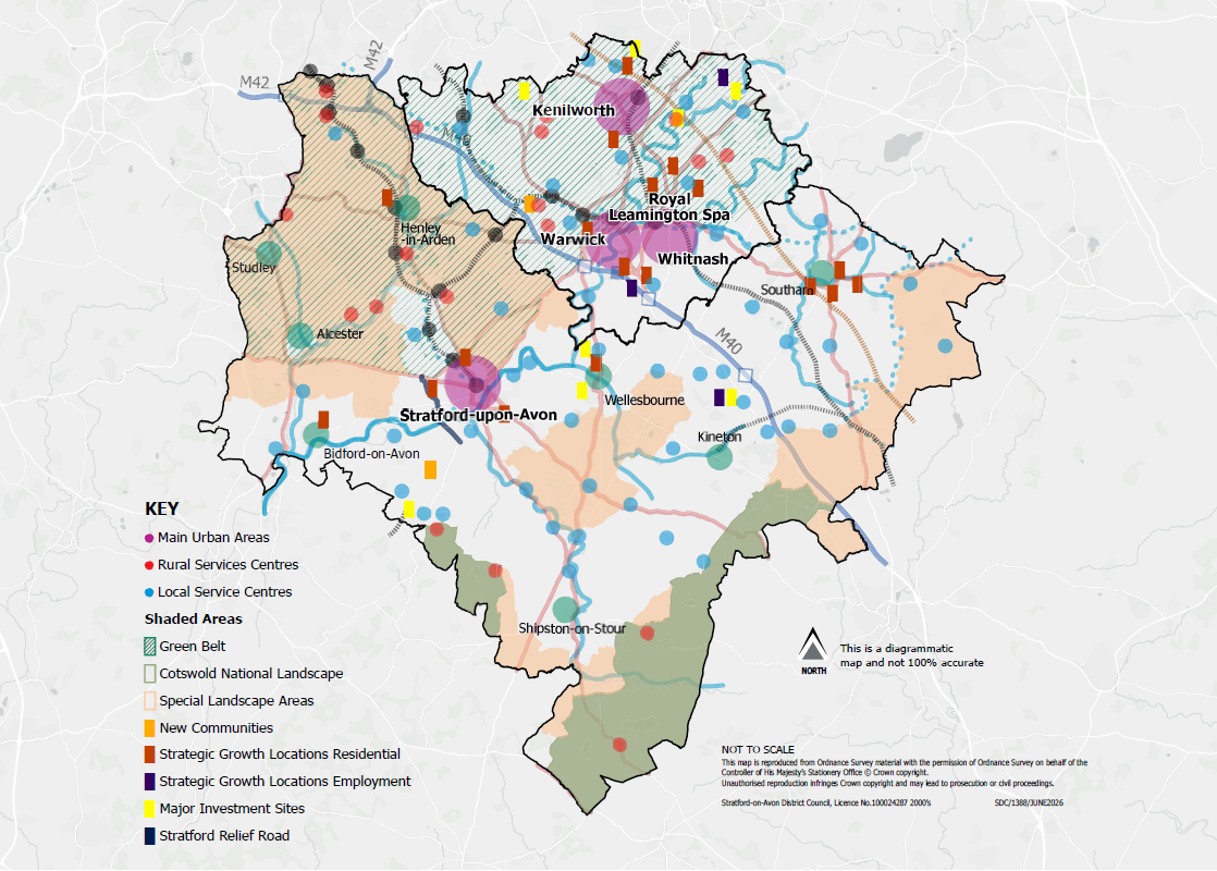
Policy Justification
2.9.2 South Warwickshire has a diverse economy with many thriving employment and research clusters covering a variety of sectors which include national and international businesses. When considered spatially, these clusters cover a core area across the centre of South Warwickshire connected by the A46 and the central section of the M40. The South Warwickshire Economic Strategy identifies a Core Opportunity Area as a way of attracting inward investment into South Warwickshire, encouraging businesses to co-locate in this area and take advantage of economies of scale
2.9.3 The Core Opportunity Area will build on existing employment hubs, harness the potential offered by co-locating businesses and research facilities and support the strategy for attracting significant inward investment to the area. This will be against the backdrop of national planning policies, most notably those relating to the Green Belt, and subject to compliance with other relevant policies in the SWLP. The Council’s will continue to seek to promote improvements to the transport network and ensure that any schemes coming forward within the Core Opportunity Area provide adequate improvements to transport, particularly active travel initiatives.
Policy DS.10 (Strategic Policy)
Major Investment Sites
In accordance with DS.3, the following Major Investment Sites as identified on the Policies Map, will be safeguarded for future employment, research and investment. Additional employment land is being provided at certain Major Investment Sites in accordance with Policy DS.5.
A. Gaydon (Proposal MIS.A)
- The existing Jaguar Land Rover and Aston Martin Lagonda employment sites to the southwest of the B4100 at Gaydon will be safeguarded for automobile research and manufacturing uses.
- 124.5ha of additional land will be safeguarded for automotive related employment uses adjacent to the existing JLR site at Gaydon
- 7.5ha of additional land to the west of the B4100 adjacent to the existing AML site will be safeguarded for automobile research and manufacturing.
- Development of the MIS should be in accordance with Proposal GAY.
- Consideration will be given to the preparation of a Local Development Order (LDO) for the site to provide certainty to both the businesses and residents regarding future investment.
B. Long Marston Rail Innovation Centre (Proposal MIS.B)
The Long Marston Rail Innovation Centre will be safeguarded for rail-based and rail-related employment, research and investment including supply chain uses, as the UK’s only looped standard gauge test-track. The operational rail connection to the national rail network will also be safeguarded.
C. South of Coventry including Coventry Airport (Proposal MIS.C)
- Land in the vicinity Coventry Airport is safeguarded for strategic employment Use Class B2 and B8 uses, as set out in Policy DS.3 (COV.4 and COV.5).
At COV.4 (Gateway South) specific requirements include:
- Delivery of 90ha Country Park
- Retention of existing employment uses on site
- Delivery of 71.8ha of strategic employment uses (Use Class E(g), B2 and B8)
- Delivery of site to be in accordance with Outline Consent Ref: W/18/0522 and subsequently approved Reserved Matters
At COV.5 (Whitley South) specific requirements include:
- Delivery of 16.3ha of strategic employment uses (Use Class E(g), B2 and B8)
- Delivery of site to be in accordance with Outline Consent Ref: W/16/0239, subsequently approved Reserved Matters and Full Planning Permission Ref: W/25/0816
- Land at Coventry Airport is allocated to support the growth of the advanced manufacturing and engineering sector and associated innovation activities
- Development of Coventry Airport should be in accordance with Proposal COV.2 – Coventry Airport.
D. Stoneleigh Park (Proposal MIS.D)
- The existing employment site at Stoneleigh Park is safeguarded for employment uses for Use Class B2, Use Class B8 and Use Class E(g) uses.
- The existing site of Stoneleigh Park will be intensified to provide approximately 5.4ha (net) of additional industrial employment land for Use Class B2, Use Class B8 and Use Class E(g) uses.
- Development of the site should be in accordance with Proposal STO.3 – Stoneleigh Park.
E. University of Warwick Main Campus (Proposal MIS.E)
- 62ha of land at the existing University of Warwick Main Campus is safeguarded for education and research and development related uses
- Future development of this site should be in accordance with this Concept Masterplan. Proposals not addressed by the Masterplan will be considered on their merits and assessed against all other relevant development plan policies. Proposals will be viewed positively where they help contribute to the University delivering a world-class educational campus with the necessary supporting facilities.
F. University of Warwick - Wellesbourne Campus (Proposal MIS.F)
- The existing development at Wellesbourne Campus site will be safeguarded primarily for employment and research and development uses, in accordance with the Policy DS.5 for Local Employment, Proposal WEL.1 and as per the Wellesbourne Campus Concept Masterplan and Character Areas Plan shown in Section 8.22.
- 47.5ha (27ha net of currently undeveloped land) is allocated primarily for research and development uses in accordance with the Concept Masterplan and Character Areas Plan shown at Section 8.22.
- Further expansion of the Campus site beyond the Concept Masterplan area will be explored with the University of Warwick. Proposals not addressed by the Concept Masterplan will be considered on their merits and assessed against all other relevant development plan policies. Proposals will be viewed positively where they help contribute to the University delivering a world-class research and development focused campus with the necessary supporting facilities.
G. Wellesbourne Airfield (Proposal MIS.G)
- The aviation function of the airfield will be safeguarded in accordance with the Memorandum of Understandings signed August 2019 and August 2022. Proposals for development associated with aviation activity requiring planning permission will be permitted subject to them not having an unacceptable effect on the environment of adjacent areas and on local residents and businesses. The eastern part of the existing Airfield (as shown on the Policy Map) will be repurposed for up to 65ha of employment uses (Use Class B2, B8, E(g) uses subject to evidence that the operational viability of the Airfield will be maintained and that the employment development proposed would specifically enable the relocation of the runway and the establishment of a more viable airport on a smaller footprint.
- Development of the site should accord with Policy DS.6 Local Employment.
- Opportunities should also be sought to incorporate an increased understanding of the history of the airfield.
H. Fen End ~ former Honiley Airfield) (Proposal MIS.H)
- The existing development on this site will be safeguarded for employment uses relating to the automotive and motorsport sectors.
- Further intensification/expansion of the existing development for employment uses may be supported, subject to demonstrating that very special circumstances exist to justify development within the Green Belt. The range of uses on the site will be restricted to the automotive and motorsport sectors.
Policy Justification
2.9.4 National Planning Policy focusses on achieving sustainable development and is underpinned by an economic objective which requires planning policies and decisions to create conditions where businesses can invest, expand and adapt, offering significant weight to support economic growth and productivity. Policies are also directed to set out a clear economic vision using criteria and identification of strategic sites over the plan period.
2.9.5 The intention of this policy is to ensure that a sufficient amount and range of employment land is both retained through appropriate existing employment sites and provides opportunity for continual expansion of the existing major employers within South Warwickshire to meet the required need across the plan period. The major investment sites (MIS) identified within this policy and their delivery would contribute to other Economic Policies within this plan and therefore the submission of planning applications on the MIS identified should conform with the package of economic policies within the SWLP.
2.9.10 The MIS identified within the policy will also be protected for employment use. The policy outlines the general support for the expansion of identified MIS and where appropriate opportunities for growth which may be located on adjacent and functionally appropriate surrounding land.
2.9.11 Other policies within this Plan may also relate to the MIS and should be referred to separately in consideration of any proposals affecting the MIS. These include Policy DS.5Locations of Local Employment as well as specific Site Proposal policies, where relevant.
Proposal MIS.A - Gaydon (Jaguar Land Rover and Aston Martin Lagonda)
2.9.12 This automotive hub is home to the iconic British brands Jaguar Land Rover (JLR) and Aston Martin Lagonda. Through the SWLP, there is an opportunity to capitalise on the existing economic base and grow this area with further automotive-related employment land. This part of South Warwickshire has the potential to intensify use of the site, and exploit the interrelationships with automotive and advanced engineering, especially in respect of alternative fuel technology.
2.9.13 Additional land is allocated at this location specifically for the expansion of JLR and Aston Martin, to support the growth of these regionally and nationally important employers. This involves, for Jaguar Land Rover, the allocation of 51ha of strategic employment land for general industrial and logistics uses, and 73.5ha specifically for testing tracks. 7.5ha is allocated for the expansion of Aston Martin Lagonda for industrial and logistics uses.
Proposal MIS.B - Long Marston Rail Innovation Centre
2.9.14 The Long Marston Rail Innovation Centre is the UK's only looped test track and with its connection to the national rail network, provides a unique opportunity to act as a catalyst for growth in the rail technology sector.
Proposal MIS.C - South of Coventry Area including Coventry Airport
2.9.15 The area of South Warwickshire to the south of Coventry has started to see considerable change. The sub-regional employment site to the south of Jaguar Land Rover's Head Quarters at Whitley is allocated for E(g), B2 and B8 class uses and comprises SEGRO Park and Whitley South. Outline planning permission has been granted for development and the parcels form part of the wider West Midlands Investment Zone.
2.9.16 The former Coventry Airport is also located adjacent to the sub-regional employment site and also forms part of the West Midlands Investment Zone. This site has already been accounted for within the strategic site supply for Area 7 of the West Midlands Strategic Employment Sites Study under its extant planning consent for the development of a Gigafactory – a large-scale battery manufacturing facility (Planning ref: W/21/1370). Whilst delivery of a gigafactory remains the primary objective for the site, it is considered appropriate to broaden the scope of potential uses on site to include other advanced manufacturing activities to afford sufficient flexibility. Full details of this site allocation are included within the separate site Proposal COV.2.
2.9.17 Significant transport infrastructure improvements have been implemented, including a new bridge over the A45 and transport improvements to connect JLR/Whitley Business Park to the new sub-regional employment site comprising Whitley South and Coventry Gateway.
2.9.18 Further transport investment is being considered in the area. A new bridge deck and signalised gyratory system will be delivered at the Stoneleigh Junction of the A46. The potential for a new railway station near Kenilworth is being explored as part of a wider multimodal transport interchange comprising bus-based park and ride and very light rail provision. The interchange would be served by a new multimodal transport corridor connecting the improved A46 Stoneleigh Junction to Warwick University and Westwood Heath Road, thereby addressing highway capacity, public transport and active travel deficiencies within the area and improving to access to employment opportunities.
Proposal MIS.D - Stoneleigh Park
2.9.19 Stoneleigh Park is located to the east of Kenilworth and south of the village of Stoneleigh, home to the headquarters of the Royal Agricultural Society for England and a number of other agricultural and countryside organisations. The park hosts a wide range of shows and events and is an established part of the rural economy both locally and nationally.
2.9.20 The site will be significantly impacted by HS2 as it intersects Stoneleigh Park. This necessity for change to the site means that the Local Plan provides an opportunity to reassess the use and purpose of the site and the density of development. The expansion of the existing site is considered appropriate to provide further opportunities for employment in this location.
Proposal MIS.E - University of Warwick Main Campus Area
2.9.21 The University is a leading employer in South Warwickshire and plays an important role within the local economy as well as being of national and international importance. The campus has been developed following a Masterplan approved in 2009 that has now largely been implemented. A further planning application granted in 2019 enabled construction of two major projects.
2.9.22 The University has aspirations to continue to improve and develop its campus and therefore the Plan will need to ensure that the aspirations of the University can be met, whilst ensuring any negative impacts of growth are mitigated. The relevant authorities worked closely with the University to develop a Concept Masterplan for the site.
2.9.23 The Concept Masterplan provides a framework for guiding the level and broad location of growth on the main University of Warwick campus. Proposals outside of the Masterplan area will be viewed positively where they help contribute to the University delivering a world-class research and development focussed campus with the necessary supporting facilities.
Proposal MIS.F - University of Warwick, Wellesbourne Campus
2.9.24 The Local Plan seeks to support and develop the integral relationship between the university campus and nearby Wellesbourne Airfield site, with the campus growing as a centre for cross-fertilisation research and development in high-tech automotive, battery and biosciences. The proximity of an operational airfield would hold the potential that aviation technology could add to these scientific endeavours.
2.9.25 Development of the site should accord with the Concept Masterplan and Character Areas Plan. Proposals outside of the Masterplan area will be explored with the University and will be viewed positively where they help contribute to the University delivering a world-class research and development focussed campus with the necessary supporting facilities.
Proposal MIS.G – Wellesbourne Airfield
2.9.26 Wellesbourne Airfield is an important local aviation asset, and its retention as a functional airfield will be a critical consideration for any further development of the site.
2.9.27 However, it is considered that the airfield site has the potential to accommodate employment development, included in use class B2, B8 and E(g) uses. This would involve the relocation of the existing runway to allow for this employment development to the east of the site. Any such employment development would be subject to demonstrating that this would not threaten the viability of the remaining airfield or aviation function of the site.
Proposal MIS.H – JLR Fen End (former Honiley Airfield)
2.9.28 The former military airfield has been used for a variety of aeronautical and automotive uses since the 1950s and most recently for vehicle testing and research and design associated with the automotive industry. It is unique in allowing the co-location of research and development facilities together with a test track for off road testing.
2.9.29 National planning policy allows for limited infilling or the partial or complete redevelopment of previously developed sites within the green belt (whether redundant or in continuing use) that would not cause substantial harm to the openness of the green belt.
2.9.30 However, the Council recognises that this site has a unique and important role in the local and subregional economy. It is considered that there may be very special circumstances to justify further development within the boundaries identified on the policies map, provided that proposed uses are relating to the automotive and motorsport industries and employment associated with these sectors.
Policy DS.11 (Strategic Policy)
Rural Economy
This policy applies to all locations outside of allocated sites and the defined Built-up Area Boundaries of settlements, as defined in Policy DS.8 and shown on the Policies Map.
Proposals for economic development in the above rural locations will be supported in the circumstances set out below. All development proposals should:
- Be of an appropriate scale to their location
- Re-use existing buildings where possible
- Not have an unacceptable impact on local roads
- Exploit any opportunities to make the location more sustainable
- Respect the character of the surrounding area
A. Agricultural and Forestry Businesses
- Conversion of building for business purposes subject to its location and character, including historic or architectural merit, being suitable for the proposed use and it having been in existence for at least ten years.
- Redevelopment at similar scale of an existing building for business purposes, excluding holiday lets, where this would result in more effective use of the site.
- Ensure that any new buildings are well related to the built form and scale of the agricultural business.
- An extension to a business in its established location, particularly if it would be unreasonable to expect the business to relocate in order to expand.
- A building or structure related to agriculture, horticulture and forestry where it is required for such purposes.
- Farm-based business activities that would help to diversify and support the viability of agricultural operations.
- New and extended nurseries
- Equine and equestrian-related activities, wherever practicable using existing buildings and structures.
B. Tourism and Leisure Businesses
- Tourism, visitor accommodation and leisure-based uses, including sport and recreation, particularly those which would help to provide local employment and support rural services.
- Purpose-built visitor accommodation that is directly associated with and related to the scale and nature of an existing use.
- Expansion of an existing holiday caravan/chalet site where this would secure benefits to its function and appearance.
- Golf courses, golf driving ranges and ancillary facilities.
Proposals should also be considered alongside Policy EC.3, in particular.
C. Other Businesses
- Conversion of building for business purposes subject to its location and character, including historic or architectural merit, being suitable for the proposed use and it having been in existence for at least ten years.
- Redevelopment at similar scale of an existing building for business purposes, excluding holiday lets, where this would result in more effective use of the site.
- Small-scale expansion of an existing group of buildings uses, excluding holiday lets, where the site is readily accessible by means of transport other than the private car.
- An extension to a business in its established location, particularly if it would be unreasonable to expect the business to relocate in order to expand.
- New and extended garden centres and nurseries open to the public where the site is readily accessible by means of transport other than the private car.
E. Proposals of Regional or National Significance
Larger scale proposals that have a regional or national significance should be directed to suitable locations within the Core Opportunity Area and will be considered on their merits. Proposals outside of the Core Opportunity Area will need to demonstrate why the particular location is both suitable and necessary and that other locations have been suitably explored and discounted.
Policy Justification
2.9.31 Rural businesses are recognised as a key part of South Warwickshire’s economy, and it is therefore vital that the continued function and expansion of rural businesses is appropriately supported by local planning policies. This includes supporting the diversification of existing agricultural businesses to ensure their viability and protect the national food supply chain. The South Warwickshire Employment Land Study (2026) identified that there are 91 'agri-tech' businesses within South Warwickshire supporting 1,610 jobs. The sub-sector is driven by rural businesses such as food production, farming, food processing, food logistics rather than high-technology companies.
2.9.32 The NPPF states that policies should create the conditions in which businesses can invest, expand and adapt, and that planning policies and decisions should enable the sustainable growth and expansion of all types of business in rural areas. The NPPF recognises that sites to meet local business and community needs in rural areas may have to be found adjacent to or beyond existing settlements, and in locations that are not well served by public transport. However, the use of previously developed land and well-located developments close to settlements should be encouraged.
Policy DS.12 (Strategic Policy)
Rural Housing
This policy applies to all locations outside of allocated sites and the defined Built-up Area Boundaries of settlements, as defined in Policy DS.8 and shown on the Policies Map. Proposals for residential development in the above rural locations will be supported in the circumstances set out below.
A. Rural Exceptions
Local communities are encouraged to bring forward proposals for affordable housing schemes which meet the needs of their communities in accordance with Policy HO.5
B. Self-Build and Custom-Build Housing
Small scale schemes for self-build and/or custom-build housing to meet an identified need where the prospective occupier has the primary influence on the design, in accordance with Policy HO.12.
C. Changes to Existing Buildings
The following proposals will also be supported in principle where they relate to existing buildings:
- Conversion and/or change to a residential use of a redundant or disused building in open countryside, constructed of brick or stone, that is Listed or of local historic, architectural or other merit. In such cases, residential should be the only viable use and the building should be capable of conversion in a manner that is appropriate to its character and setting.
- A dwelling that forms part of the conversion of a building in open countryside where it is ancillary to a business and is necessary to ensure the efficient and secure operation of the business.
- A replacement dwelling subject to its scale and design not causing inappropriate harm to the character of the area or to neighbouring properties.
- Alterations and extensions to existing buildings in accordance with Policy BN.13 subject to their scale and design not causing inappropriate harm to the character of the area or to neighbouring properties.
D. New Homes
New homes will also be supported in principle in the following circumstances:
- Redevelopment of a site for residential development where the current use has been the cause of prolonged environmental conflict.
- A small-scale expansion of an existing lawful mobile or park home site, including Gypsy & Traveller site and Travelling Showpeople yard where this would secure benefits to its function and appearance.
- A permanent dwelling for occupation by a person engaged in an agricultural operation or other form of use that can only reasonably be carried out in the countryside, subject to a functional need being established.
- A new single dwelling in open countryside which is of exceptional quality and design and makes a positive contribution to the character of the local area.
DS.12 Development Management Considerations
- In relation to part C1 in the policy - there may be circumstances where the conversion to residential use of a building of historic or other interest which is situated in open countryside offers the only viable prospect of maintaining that building in a good state of repair. However, evidence must be produced to show that the building has been robustly marketed for a business use. In the case of a Listed Building it will be necessary to demonstrate that a business use is not a viable option because of the particular characteristics of the building and/or its site and surroundings.
- In relation to part C2 in the policy - schemes with an element of residential development will be considered when a dwelling is proven to be essential for the efficient and secure operation of a business use. Sufficient evidence will be sought by the Local Planning Authority through a comprehensive appraisal of the business in order to justify permanent residential accommodation.
- In relation to part C2 in the policy - a business plan should be submitted with a planning application to demonstrate the degree of linkage between the business and residential uses. In all cases the scale of the residential element must be directly related and subsidiary to the business uses. Any dwelling approved on this basis will be subject to a strict occupancy condition.
- In relation to part C3 in the policy - unless significant environmental benefits would accrue, a replacement dwelling should be located within the curtilage of the existing dwelling. The existing dwelling should have the benefit of a lawful planning use and not have been substantially demolished and/or abandoned.
- In relation to part D1 in the policy – a documented history of environmental conflict will be required to accompany a planning application to seek to justify a redevelopment scheme.
- In relation to part D2 in the policy - any proposal must be comprehensive and show how improvements to the existing site would be secured.
- In relation to part D3 in the policy - the Local Planning Authority will require sufficient evidence to demonstrate that there is an essential need for a person or persons to be present on the site at all times sufficient to justify the provision of residential accommodation. A case based solely on grounds of security will not necessarily be sufficient. The future sustainability of the enterprise will be taken into consideration along with established functional and financial tests.
Policy Justification
2.9.33 The SWLP seeks to ensure that all three aspects of sustainable development - environment, economy and society - are achieved in a balanced manner in the countryside and the villages that lie within it. The attractive environment, combined with relatively low crime and unemployment rates, make rural parts of Stratford-on-Avon District attractive places to live, work and visit. This exerts pressure for development in the countryside.
2.9.34 The importance of maintaining and enhancing the environmental quality of the countryside, whilst at the same time providing for the needs of rural communities and businesses, is a critical function of planning policy relating to the countryside. Rural services have declined significantly in recent years through the processes of centralisation and rationalisation. Public transport is poor or non-existent in a number of rural settlements and house prices remain high and out of reach of those in rural jobs. In many villages there remains a significant need for affordable housing. Given all of the above, the approach in the SWLP seeks to strike the right balance of ensuring the vitality of rural villages remains. This will be achieved by supporting developments that meet local needs, including through the production of neighbourhood development plans, whilst at the same time, not requiring or expecting development to be brought forward in such locations.
2.10 West Midlands Green Belt
Policies within this section contribute to achieving the following Strategic Objectives:
SO4. Making effective use of land and natural resources
SO5. Contributing towards Net Zero Carbon targets
SO6. Creating attractive places and spaces
2.10.1 The purpose of the Green Belt is to maintain the openness of land and prevent urban sprawl i.e. unplanned development. Allocated sites are by definition, planned, and therefore do not constitute urban sprawl. Green Belt is not a landscape designation and can contain both greenfield and brownfield sites. In accordance with the NPPF, grey-belt sites may be suitable for development. The extent of the West Midlands Green Belt within South Warwickshire is shown on the Policies Map.
Policy DS.13 (Strategic Policy)
Green Belt
A. Alterations to the Green Belt through the SWLP
The extent of the Green Belt is defined on the Policies Map. The following alterations to the Green Belt are made in order to deliver the proposals within the SWLP. This includes insetting specific villages from the Green Belt and alterations to the Green Belt boundary around specific settlements.
1. Built-up areas of villages:
- Bubbenhall
- Claverdon
- Hatton Station
- Snitterfield
- Tanworth-in-Arden
- Wilmcote
2. Land allocated for Development ~ New Settlements and SGLs
- Hatton (proposal HAT)
- Henley-in-Arden North-west (proposal HEN.1)
- Kenilworth South (proposal KEN.1)
- Lillington East (proposal LIL)
- Leamington Spa North (proposal LEA.1)
- South of Coventry (proposal COV.1)
- Stratford-upon-Avon North (proposal STR.1)
- Coventry Airport (proposal COV.2)
3. Land allocated for Development ~ LGLs (in accordance with Policies DS.5, DS.6 and DS.7)
- Alcester
- Hampton Magna
- Kenilworth (employment site)
- Studley
- Stoneleigh (employment sites)
4. Revisions to accommodate permitted development
- Cubbington
5. Other changes to Green Belt boundaries
- Correction of boundary anomaly at Leek Wootton
B. Alterations to the Green Belt through Neighbourhood Development Plans
Neighbourhood Planning groups are empowered to make changes to Green Belt boundaries in their defined neighbourhood area through Neighbourhood Development Plans, where all of the following apply:
- The site is adjacent to the built-up area of a settlement, which is itself excluded from the Green Belt, as defined on the policies map;
- The site is required to accommodate a local need;
- The need for Green Belt release is established with reference to relevant policy as set out in the NPPF;
- The new Green Belt boundaries are established with reference to relevant policy as set out in the NPPF.
- Any alterations are consistent with the SWLP
C. Proposals on land excluded from the Green Belt
Where proposals are located on land that has been removed from the Green Belt through the SWLP, or in Neighbourhood Development Plans, relevant policy as set out in the NPPF will apply.
D. Proposals in the Green Belt
Where proposals are located in the Green Belt, relevant policy as set out in the NPPF will apply.
DS.13 ~ Development Management Considerations
Where sites are released for a local need, this could be for housing as demonstrated through a recent Housing Needs Survey; for employment to support the vitality and/or growth of local businesses; or for health, education or community facilities.
NPPF paragraph 156 requires that the “Golden Rules” apply to land released from the Green Belt through plan preparation or review, where such changes to Green Belt boundaries were made after the publication of the Framework.
For the avoidance of doubt, the Golden Rules do not apply to land removed from the Green Belt in the 2016 Stratford-on-Avon Core Strategy or the 2017 Warwick District Local Plan, whether this land was proposed for allocation or safeguarded for potential future development. Both of those plans were adopted before the introduction of the Golden Rules to national policy.
Policy Justification
2.10.2 Parts of the West Midlands Green Belt extend into South Warwickshire. A Green Belt Review has been undertaken, which assesses:
- How different areas of the Green Belt perform against the 5 purposes of Green Belt set out in national policy;
- Whether different areas of the Green Belt could be considered to be grey belt;
- Whether evidence suggests that existing villages within the Green Belt should be excluded from the designated area;
- Whether there would be cumulative harm to the wider Green Belt if combinations of sites were excluded from the designated area.
2.10.3 Exceptional circumstances exist which justify making changes to Green Belt boundaries. These boundary changes are necessary in order to deliver a sustainable spatial growth strategy, locating housing and employment growth in the most appropriate locations. The pattern of existing larger settlements and public transport infrastructure in South Warwickshire means that many of the most sustainable locations fall within the Green Belt. The Green Belt releases align with and underpin the Development Strategy (see Section 2.5 above) and are critical to its success. The SWLP needs to address the wider sub-regional context which is to the north in Green Belt locations. The Development Strategy sets out a pattern of growth that fosters sustainable development, generally seeking to meet needs closer to areas where they derive. This explains the decision for each District to meet its own needs and for the scale of Green Belt release in Warwick District. Long Marston Airfield is perhaps an exception to this, but given the scale of the development requirements and the wider benefits that a new community in this location can bring – as well as the long-term potentially for strategic fit - LMA is consistent with the Development strategy.
2.10.4 The exceptional circumstances for removing land from the Green Belt in general, and for each specific change proposed, are set out in full in Topic Paper. The role of Grey Belt has been considered but it is right that this policy assessment has not been the driving factor in the creation of the Development Strategy. The Development Strategy must come first with assessments regarding Green Belt and Grey Belt informing which sites with that overall strategy could be released.
2.10.5 NPPF paragraph 145 allows for detailed amendments to Green Belt boundaries to be made through Neighbourhood Development Plans, where a need for such changes has been established through strategic policies. The need for Green Belt boundary changes is established in this Green Belt policy, in combination with Policies DS.2, DS.5, DS.6 and DS.7.
2.10.6 The SWLP does not duplicate the NPPF in respect of the Green Belt. Proposals will be assessed against the NPPF, with reference to the evidence in the South Warwickshire Local Plan Green Belt review in the first instance, or other suitable evidence where appropriate.
2.11 Safeguarding our Valued Landscapes
Policies within this section contribute to achieving the following Strategic Objectives:
SO4. Making effective use of land and natural resources
SO6. Creating attractive places and spaces
SO7. Protecting and enhancing our heritage and cultural assets
SO10. Protecting and enhancing our environmental assets and working towards environmental net gain
2.11.1 Great weight will be given to conserving and enhancing the landscape and scenic beauty of the Cotswolds National Landscape; this includes consideration of the impact of development outside the National Landscape, where such development has the potential to harm the natural beauty of the National Landscape (for example, as a result of impacts on views to and / or from the National Landscape). The boundary of the Cotswolds National Landscape, and the 3km buffer is shown on the Policies Map.
2.11.2 In addition to the Cotswolds National Landscape, South Warwickshire is home to a number of other important local landscapes, each distinctive, valued and special in its own right. These different landscapes are central to the character of South Warwickshire, not only the character of its countryside but also the character of its settlements.
Policy DS.14 (Strategic Policy)
Protecting the Cotswolds National Landscape
Development within the Cotswolds National Landscape will be limited to meeting local needs only and will not help address wider South Warwickshire needs or the unmet needs of neighbouring authorities. Development that is necessary for the conservation, restoration or long-term management of the National Landscape will be supported. The Cotswold National Landscape, and the 3km buffer are shown on the Policies Map.
A. Proposals within the National Landscape
Development proposals will be required to:
- Conserve and enhance the natural beauty and character of the National Landscape, including its special qualities, landscape and scenic beauty, cultural heritage (including historic environment), natural heritage (including biodiversity) and relative tranquillity (including dark skies);
- Sensitively locate and design development so as to avoid and minimise adverse impacts on the natural beauty of the National Landscape;
- Demonstrate that all reasonably practicable steps have been taken to further the purpose of conserving and enhancing the natural beauty of the National Landscape, over and above avoidance and mitigation of harm;
- Be consistent with - and help to deliver - the policies, targets and outcomes of the Cotswolds National Landscape Management Plan;
- Prevent cumulative impacts which lead to incremental change to the National Landscape’s special characteristics
- Limit the scale and extent of development, for example, by being proportionate to the settlement in which it is located.
- Demonstrate that in exceptional circumstances, where the public benefits outweigh the harm and cannot be delivered elsewhere, proposals and must avoid, minimise, mitigate, and as a last resort compensate, for any residual adverse effects on the natural beauty of the National Landscape. This must be supported through, robust justification and proportionate evidence against the statutory purposes of the National Landscape.
B. Proposals within the National Landscape Buffer
Development proposals within the 3km buffer of the Cotswolds National Landscape will consult the National Landscape Board as per the identified consultation thresholds and may need to give consideration to the criteria set out in Part A of this Policy.
DS.14 ~ Development Management Considerations
Development proposals outside the National Landscape buffer may still impact the setting of the National Landscape and may still be necessary of consideration in relation to the conditions of this policy.
Policy Justification
2.11.3 Nationally Designated Areas, including National Landscapes afford protection from development to ensure their scenic beauty is conserved and enhanced, and National Policy and adopted legislation, gives great weight to this. Historically called the Cotswolds Area of Outstanding Natural Beauty, the designation is now referred to as the Cotswold National Landscape. This new name does not affect/alter the level of protection afforded to the area.
2.11.4 8.2% of the South Warwickshire area (including 10.6% of Stratford-on-Avon District) overlaps with the Cotswold National Landscape and 5.1% of the Cotswold National Landscape overlaps with South Warwickshire. The special qualities of the National Landscape, which make the area distinctive and are considered valuable, are outlined within the Cotswold National Landscape Management Plan (2025-2030) or any subsequent updates. It is these attributes which it is considered important to conserve, enhance and manage, to ensure the character of the area is not lost.
2.11.5 Section 85 of the Countryside and Rights of Way Act outlines Local Authorities statutory duty to ‘seek to further the purpose of conserving and enhancing the natural beauty’ of areas of outstanding natural beauty. This goes beyond previous requirements to ‘have regard to’. This duty to ‘seek to further’ also applies in relation to development in the setting of the Cotswold National Landscape, as outlined in Defra’s guidance on the ‘seek to further’ duty. NPPF Paragraph 189 outlines that great weight should be given to conserving and enhancing the landscape and scenic beauty of National Landscapes and outlines that development within the setting of National Landscapes should be sensitivity located and designed to avoid or minimise adverse impacts. Case law has clarified that this great weight is a relevant consideration for development within the setting of National Landscapes as well.
2.11.6 The Cotswolds Conservation Board is responsible for producing a Management Plan and the latest version covers the period 2013-2018. This is a statutory plan and is recognised as being a material consideration in the determination of planning applications. The Cotswold Conservation Board should be engaged as necessary and in line with their current consultation thresholds, to ensure that development proposals within the National Landscape, and its setting are considered by this important Stakeholder.
2.11.7 The implementation of a 3km buffer around the Cotswold National Landscape (as shown on the policies map) is designed to ensure the ‘setting’ of the National Landscape is given due consideration in determining development proposals.
Policy DS.15 (Strategic Policy)
Special Landscape Areas
A. Protecting Landscape Character
The high landscape quality of the Special Landscape Areas, including their associated historic and cultural features, will be protected by resisting development proposals that would have a harmful effect on their distinctive character and appearance which make an important contribution to the image and enjoyment of South Warwickshire. The cumulative impact of development proposals on the quality of the landscape will be taken into account.
Development proposals relating to settlements that lie within a Special Landscape Area must respect the current and historic relationship of that settlement within the landscape.
B. Special Landscape Areas
The following Special Landscape Areas are identified and their extent is shown on the Policies Map:
- Arden
- Cotswold Fringe
- Feldon Parkland
- Ironstone Hills Fringe
- River Leam and Surrounds
Policy Justification
2.11.8 One of the NPPF’s overarching objectives is to protect and enhance our natural, built and historic environment. NPPF Paragraphs 20, 135 and 187 all express the importance of protecting the natural landscape and utilising Special Landscape Areas is one way to protect the distinctive character of an area.
2.11.9 Special Landscape Area designations are a response to an areas defined qualities and these have been identified as part of a study looking at landscape designations. The purpose of the Special Landscape Area designation is to protect, enhance and facilitate better management of the best of the area’s landscapes outside the Cotswolds National Landscape. The Special Landscape Areas are focussed on larger scale areas which are of generally higher landscape value.
2.11.10 Special Landscape Areas have to be, by definition, ‘special’ at a district level to merit inclusion. All landscapes are important, especially to their local residents, and Policy DS.15 (above) emphasises the importance of assessing thoroughly the impact of proposed development on all parts of South Warwickshire’s countryside. However, to define entirety of South Warwickshire as ‘special’ would potentially undermine the purpose of designating specific areas for their landscape quality. Designation must be driven by the key qualities of a particular area of landscape. On that basis, the Special Landscape Areas identified represent particularly high-quality countryside in the context of South Warwickshire, based on their landscape and scenic quality, as well as natural and historic features.
2.12 Enhancing the Character of South Warwickshire
Policies within this section contribute to achieving the following Strategic Objectives:
SO4. Making effective use of land and natural resources
SO6. Creating attractive places and spaces
SO7. Protecting and enhancing our heritage and cultural assets
SO8. Improving the quality of life of our communities
SO9. Connecting people to places
SO10. Protecting and enhancing our environmental assets and working towards environmental net gain
2.12.1 Pressures for growth, incremental change, and the expansion of built form mean that the landscape is increasingly vulnerable to erosion of character and loss of distinctiveness. It is therefore essential that new development conserves and enhances landscape qualities, supports wider green infrastructure and nature recovery objectives and contributes to climate resilience and biodiversity. In assessing proposals, consideration will be given not only to the direct effect of development but also to the cumulative impact of multiple changes over time on the character, quality and experience of the wider landscape.
Policy DS.16 (Strategic Policy)
Protecting, Enhancing and Restoring Landscape Character
A. Landscape Character and Enhancement
Development proposals must:
- Demonstrate how they have been informed by and respond positively to the local distinctiveness and historic character of South Warwickshire’s diverse landscapes, including the relevant Landscape Character Area descriptions and management guidelines.
- Protect landscape character and avoid adverse effects on features that contribute to the character, history or setting of a settlement or landscape.
- Incorporate measures to enhance and where appropriate, restore the landscape character of the locality, proportionate to the scale of development and contribute where relevant to wider green and blue infrastructure and nature recovery objectives.
- Development layout, design and masterplanning must be landscape led, demonstrate how the landscape context has shaped the form, density, orientation, movement network, open space structure and overall design approach from the earliest stages and supported an early-stage landscape appraisal that demonstrates how landscape considerations have shaped the design from inception
- Must be sensitive to an area’s capacity for change, acknowledge cumulative effects and guard against the potential for coalescence between existing settlements
B. Minimising Visual Impacts
- A proportionate Landscape and Visual Impact Assessment (LVIA) will be required for all major developments (as defined in the NPPF), proposals over 0.5ha or those that affect the setting of heritage assets.
- Development that would result in harm to the existing landscape, will only be supported if it can be demonstrated that the harm is unavoidable and outweighed by wider public benefits. Any harm to such features must be clearly justified and shown to be unavoidable, with appropriate mitigation secured.
- New landscaping must be incorporated to reduce predicted visual effects and enhance the existing landscape using native and locally characteristic species. Planting should be implemented at the earliest practicable stage and provision for long term establishment, management and maintenance must be secured through planning conditions or obligations.
- Development must avoid locations where it would appear visually intrusive or harm the openness, tranquillity or rural character of the area, particularly where these qualities are identified as key characteristics of the relevant LCAs.
- Proposals must demonstrate that key viewpoints and public visual receptors have been assessed, that alternative siting or design options have been considered and that measures have been incorporated to reduce visual prominence, including avoiding skyline intrusion or excessive landform alterations.
DS.16 ~ Development Management Considerations
In relation to Part A1 of the Policy ~ Landscape Character Area descriptions and management guidelines set out the special characteristics of the landscape character areas and provide guidelines which provide invaluable strategies for managing and enhancing these landscapes.
In relation to Part B1 of the Policy - LVIAs must follow current Landscape Institute guidance and assess effects on relevant LCAs, key visual receptors, and public viewpoints, including cumulative effects, seasonal variation, and where relevant nighttime impacts.
Policy Justification
2.12.1 The landscapes of South Warwickshire are a defining feature of its character, identity and environmental quality. Development must be informed by and respond positively to; the distinctive landscape character identified in the Landscape Character Assessment and related evidence. Development should be designed and located in a way that conserves and enhances landscape qualities, minimises adverse effects, and contributes to the restoration and strengthening of landscape features. In considering proposals, attention will be given not only to individual impacts but also to the cumulative effects of development on the character and quality of the wider landscape.
2.12.2 South Warwickshire’s landscapes are a defining environmental and cultural asset. National policy requires planning decisions to recognise the intrinsic character and beauty of the countryside, protect valued landscapes, conserve heritage assets and their settings and reinforce local distinctiveness. The Landscape Character Assessment provides a detailed understanding of the districts varied landscapes including landform vegetation patterns settlement form historic field patterns key views and areas of high sensitivity.
2.12.3 Landscape led design is essential to ensuring that development responds to landform key views settlement patterns and landscape sensitivities from the outset rather than relying on retrofitted mitigation. This approach ensures that development reinforces local distinctiveness, respects settlement patterns, and avoids avoidable harm to landscape character and visual amenity.
2.12.4 Requiring proportionate Landscape and Visual Impact Assessments (LVIA) for major development, larger sites and proposals in sensitive locations ensures that landscape and visual effects are properly understood including cumulative seasonal perceptual and nighttime impacts. This evidence is essential to shaping siting scale layout and design to avoid or minimise harm and where possible deliver landscape enhancement or restoration. The policy applies proportionality with requirements scaled to the sensitivity of the location and the nature of the proposal.
2.12.5 This policy therefore provides a robust, evidence-based framework to protect, enhance and restore the districts landscape character, settlement patterns and visual amenity for the future generation, while enabling high quality, landscape led development that responds positively to its context.
Policy DS.17 (Strategic Policy)
Maintaining Settlement Identity and Areas of Restraint
Gaps between settlements play a vital role in maintaining their unique identity, rural character and landscape setting. These gaps must be preserved. Development that would erode the function of a settlement gap will not be supported unless it is demonstrated that no reasonable alternative locations exist outside the gap.
A. Preventing Coalescence
Development within settlement gaps must:
- Preserve the openness, rural character and both the visual and perceptual separation between settlements including the experience of leaving one settlement before entering another. Particular regard must be given to views from public rights of way, highways and settlement approaches and historic features noted by Historic England.
- Reference should be made to the Warwickshire Landscape Guidelines, and any future character and strategic gap studies, including those prepared as part of Neighbourhood Development Plans. The historic settlement and field patterns which are identified as being important to the local character should be protected.
- Avoid introducing built form, lighting, access roads or other urbanising features that would diminish the rural character or function of the gap.
- Be assessed cumulatively alongside other existing and proposed development to ensure that the function, openness or character of the gap is not incrementally eroded.
- Demonstrate that alternative siting or design options have been fully considered to avoid harm to the gaps purpose and effectiveness.
B. Identified Areas of Restraint
The boundaries of the Areas of Restraint are shown on the Policies Map.
Land designated as an Area of Restraint makes an important contribution to the character of the settlement and the wider South Warwickshire landscape. Development must not harm or threaten the open nature of designated areas of restraint, taking into account any possible cumulative effects.
Planning permission for a large-scale form of development in an Area of Restraint will only be granted where a scheme would have demonstrable community benefits and contribute significantly to meeting the strategic objectives of the South Warwickshire Local Plan. It will also need to be demonstrated that no suitable alternative site in the locality outside the Area of Restraint is available for the proposed development.
Projects which protect and enhance the landscape character and visual amenity of Areas of Restraint will be encouraged, as will the promotion of beneficial uses such as public access, nature conservation and food production.
Policy Justification
2.12.6 The NPPF does express the importance of preserving and enhancing landscapes and ensuring that developments are sympathetic to local character and history, including the landscape setting.
2.12.7 Strategic and local settlement gaps maintain the separate identity of settlements prevent coalescence and safeguard both visual and perceptual separation. These gaps perform an important function role in maintaining openness rural character and the experience of leaving one settlement before entering another. Considering cumulative effects is essential as incremental change can erode the function of these gaps over time.
2.12.8 Identifying Areas of Restraint recognises the importance of open land within and around urban areas and its value to local people. Whilst open countryside is protected from most forms of development, this may not always be sufficient to protect areas of sensitive land such as river valley corridors on the fringes of a settlement which can be under particular pressure for development and intensified use.
2.12.9 Areas of Restraint are not considered to be local landscape designations in that they do not relate primarily to the quality of the landscape itself. They apply to relatively small areas within or adjacent to settlements and their overriding purpose is to protect the inherently open nature of a particular area because of the valuable contribution it makes to the character and physical form of the settlement. This includes significant areas of open space within the urban area or a physical feature which is important in establishing its setting.
2.12.10 It is not intended to restrict all forms of development within Areas of Restraint. There is a wide range of activity supported by each of them, mainly of an agricultural or recreational nature. It is reasonable to allow these uses to be maintained and to take account of their needs. On that basis, various forms of development may be appropriate, including limited extension or alteration to existing buildings, buildings related to existing or proposed outdoor sport and recreation facilities, cemeteries, allotments, farm diversification schemes and small-scale additions to existing groups of farm buildings.
2.12.11 Designated Areas of Restraint are shown on the Policies Map.
Policy DS.18 (Strategic Policy)
Well-Designed Places
Development proposals should contribute to high-quality places. Well-designed development will be achieved by ensuring all the following criteria, where applicable, are satisfactorily addressed. To demonstrate this, proposals should be accompanied by a Design Statement that assess the site design constraints, explores the design opportunities the site offers and demonstrates how the criteria set out in this policy have been met. Development proposals that are not well-designed will be refused.
Development Proposals should:
A. Context
- Demonstrate a sound understanding of the distinct features, history, and culture of the site and its wider context.
- Relate well to the site and its context, being well-integrated to their surroundings.
- Be both influenced by, and influence their context positively through their layout, form, density, scale, massing, appearance, access, movement, and landscape.
B. Identity
- Enhance the sense of place, responding to the character and distinctiveness of the site and its context, while not preventing or discouraging appropriate innovation or change.
- Create a coherent identity that can be widely recognised and identified with.
- Create high quality, welcoming, attractive, and distinctive places through their layout, form, density, scale, massing, appearance, access and movement networks, and landscape.
C. Built Form
- Use their layout, form, density, scale, massing, appearance, access, movement, and landscape to create high quality places with a recognisable hierarchy of streets and spaces that are walkable, easy to navigate, and memorable, as well as being tenure-neutral and socially inclusive.
- Enhance existing and frame new internal and external sightlines and views of features and landmarks.
- Clearly define public and private spaces and have a high standard of amenity and privacy for existing and future users.
- Deliver effective measures to limit crime, disorder, and the fear of crime.
D. Movement
- Prioritise active travel movements, both in the site and adjoining neighbouring areas.
- Create a genuine choice of sustainable transport modes, taking account of the diverse needs of all the potential users.
- Enhance the movement network, creating routes and spaces that are safe, accessible, inclusive, convenient, direct, coherent, comfortable, and attractive, promoting activity and social interaction.
- Promote opportunities to deliver future connections and do not prejudice the development potential of adjoining land.
E. Nature
- Make best use of existing and incorporate new natural features into a multifunctional network that supports place quality, native biodiversity, water management, and addresses climate change mitigation and resilience.
- Create a variety of natural and designed landscapes with different functions to support a diverse range of needs, promoting health, wellbeing, and social inclusion.
F. Public Spaces
- Create a hierarchy of public spaces that incorporate natural features and support a wide variety of activities.
- Include well-located public spaces that encourage social interaction and promote health, wellbeing, social and civic inclusion.
- Ensure public spaces feel safe, secure, and attractive for all through an active relationship with the enclosing-built form.
- Prevent the creation of vehicle dominated environments.
G. Liveability
- Optimise the potential of the site and context to create an appropriate mix of uses, including amenities, services, facilities, public transport, and employment opportunities to support healthy life.
- Promote health and wellbeing by providing a high standard of internal and external environments for their users and surrounding occupiers, satisfactory floor-to-ceiling heights, internal and external storage, sunlight, daylight, air-quality, and ventilation, whilst protecting users from unacceptable levels of noise, pollution, and contamination. Internal layouts should provide for practical and useable space.
- Meet the highest standards of accessibility and inclusion for potential users regardless of disability, age or gender;
H. Resources
- Use their layout, form, density, scale, massing, appearance, access, movement, and landscape to reduce their resource requirement, including land, materials, energy, and water.
- Be fit for purpose, function well, and resilient to adaptation over time, adding to the overall quality of the area and limiting need for redevelopment, and incorporate materials and technologies to limit their environmental impact.
- Plan for the long-term stewardship by communities, landowners, and authorities, ensuring their users can establish a sense of ownership and belonging.
DS.18 ~ Development Management Considerations
Design Statements should tell the ‘design story’ clearly showing how the proposed design is the outcome of the design process and based on a full understanding and analysis of the unique context at settlement, local and site level (as appropriate). This can be done using a concept statement approach. Useful guidance is set out in Design and Access Statements Guide produced by the Commission for Architecture and the Built Environment[9].
Design Statements should also show how pre-application discussions with key stakeholders have influenced the proposed design, including (but not limited to) town or parish councils, civic groups, Police Architectural Liaison Officers, Environment Agency, Historic England, Warwickshire County Council (including Archaeology, Ecology, Highways and other services), and Stratford-on-Avon District Council (including Planning, Conservation and Environmental Health Services).
In relation to Part A of this policy ~ Much of the basis of good design is understanding the context of the site. Proposals do not necessarily need to respond physically to the history or culture of the site; but to make informed design choices, the site context must be understood.
In relation to Part B of this policy ~ Identity is important in good design to create meaningful and unique environments that build a sense of place and belonging and distinguish places from others.
In relation to Part C of this policy ~ Clearly defined public and private areas can help to avoid the conflict that can arise from ambiguity and ensure high standards of both public and private amenity, as well as privacy where it’s needed. This can be achieved with public streets and spaces enclosed by active frontages, careful arrangement of private rear gardens, and the use of suitable boundary treatments to front gardens.
In relation to Part C of this policy ~ Careful planning and design create the right conditions for people to feel safe and secure, without the need for additional security measures. These include:
- buildings around the edges of a space;
- active frontages along its edges, provided by entrances onto the space and windows overlooking it, so that people come and go at different times;
- natural surveillance from inside buildings provided by windows and balconies, so that users of the space feel they might be overlooked by people from inside;
- reasons for people to enter into the space, for an activity or destination or because it is on a natural line of direction of travel;
- risk assessment and mitigation at an early stage of the design process, so security measures can be integrated into positive design features.
In relation to Part D of this policy ~ A distinction is drawn between active travel and the broader category of sustainable travel. Active travel includes all modes involving physical activity, including walking, cycling, wheelchair and pushchair use, foot-powered scooters etc. These modes of transport are prioritised. Sustainable travel includes active travel but also covers public transport including bus and rail.
In relation to Part D of this policy ~ Enhancement to the movement network should consider all stages of the journey. For example, the benefits of a new cycle path can only be realised if it connects to a wider network; if secure and conveniently located cycle storage is available at new homes; and if appropriate cycle racks are provided at key destinations such as schools, shops, community facilities, places of employment, and public transport interchanges.
In relation to Part E of this policy ~ Further detail on multi-functional natural networks can be found in Policies ID.10 and ID.11.
In relation to Part F of this policy ~ Public spaces are vital to provide opportunities for people to move, take part in recreation and interact with each other. Public spaces can serve different purposes and come in different sizes, from large parks and civic squares to smaller or more informal spaces such as small playgrounds and street level spaces. Where public spaces are to be incorporated into schemes, it should be identified what purposes those spaces will serve and how they are sited, designed and managed to ensure they deliver for their intended purposes.
In relation to Part G of this policy ~ Developments should meet the needs of their intended users and the surrounding communities. This includes considering the practical elements of design to ensure good living conditions for occupiers and surrounding occupiers.
In relation to Part H of this policy ~ Guidance on appropriate densities will be set out in relevant Design Codes. In the absence of a Design Code, the density of development should be optimised and appropriate, having regard to Chapter 11 of the NPPF, and the prevailing local character.
Policy Justification
2.12.12 Good design is fundamental to good planning. It is a key aspect of sustainable development, and it creates places that positively impact people and the environment. Chapter 12 of the NPPF highlights the importance of good design and states that significant weight should be given to development which reflects local design policies and government guidance on design, and to outstanding or innovative designs which promote high levels of sustainability or help raise the standard of design more generally. Permission should be refused for development of poor design that fails to take the opportunity for improving the character and quality of an area and the way it functions.
2.12.13 This policy applies to all forms of built development. It is necessarily broad, and certain elements of the policy are not relevant to every form of development. Similarly, the information required to demonstrate compliance with the policy will vary depending on the type and scale of development proposed. Early engagement with the Local Planning Authority Development Management Service is encouraged to understand what is required in each instance, and these requirements will be proportionate and reasonable. This policy is based upon principles set out in the National Design Guide.
Policy DS.19 (Strategic Policy)
Design Codes
Development proposals that comply with all relevant local Design Codes will be supported and must provide sufficient information to clearly demonstrate how design expectations of relevant Design Codes have been met.
The purpose of a Design Code is to set out a clear design framework so that proposals that accord with its parameters can be approved. Design Codes are not intended to stifle innovation or creativity and there may be instances where proposals come forward that are not consistent with the Design Code. In such circumstances, proposals must still adhere to the principles of good design as set out in Policy DS.18 and be of high quality. Departures from the Design Code must be fully justified and will be considered on their own merits.
Find out more about the South Warwickshire Design Code.
Policy Justification
2.12.14 The South Warwickshire Local Plan will be supported by a range of Design Codes. Where such a code exists, the code must be used to guide the design of proposals. In some locations, more than one code may apply covering different geographies – for example an area-wide code and a site-specific code may both apply.
2.12.15 In the absence of a specific local design code, the National Design Guide applies: https://assets.publishing.service.gov.uk/media/602cef1d8fa8f5038595091b/National_design_guide.pdf
2.12.16 The information required to demonstrate compliance with Design Codes will vary depending on the type and scale of development proposed. Early engagement with the Development Management team is encouraged to understand what is required in each instance, and these requirements will be proportionate and reasonable.
Policy DS.20 (Strategic Policy)
Densification and Advanced Methods of Construction
A. Promoting Densification
In accordance with Policies DS.18 and DS.19, development proposals should make the most effective use of land by seeking to maximise site densities across South Warwickshire. Higher densities are particularly encouraged within the existing Built-up Areas of the Main Urban Areas, Main Service Centres and Local Service Centres, as set out in Policy DS.8.
Proposals for major residential development within the existing Built-up Areas of Main Urban Areas, and within 1km of a railway station will be expected to achieve a minimum density of 60 dph unless site-specific circumstances indicate that this is not appropriate and robust justification is given.
Proposals for major residential development within the existing Built-up Areas of other settlements and within 500m of a railway station, will be expected to demonstrate how they have optimised density appropriate to the site context.
Proposals for additional dwellings on in the defined Built-up Areas will be supported. This may include:
- Re-use of redundant buildings
- Conversion of upper storeys of existing non-residential buildings
- Infill development on empty plots
- Additional storeys on existing buildings
- Where relevant, proposals will need to demonstrate that there is no significant loss of viable retail or employment floorspace
B. Encouraging Advanced Methods of Construction
Acknowledging their sustainability credentials and their ability to delivery homes quickly, proposals that utilise Advanced Methods of Construction will be supported. To ensure a design that is appropriate to the local context, all proposals should be supported by an agreed Design Code in accordance with Policy DS.19.
Policy Justification
2.12.17 The benefits of building at increased densities are well-established. Not only does it reduce overall land-take, but it also encourages walking, cycling and use of public transport as well as potentially providing for a greater number of smaller homes, which in turn, can be more affordable. The SWLP therefore seeks to promote building at increased densities across South Warwickshire, not just on the allocated sites, but also within the built-up areas of the Main Urban Areas, main Service Centres and Local Service Centres.
2.12.18A particular focus for higher densities is sites with easy access to public transport facilities.
2.12.19 The National Model Design Code identifies the area typology “Urban neighbourhoods” as typically having net housing densities of 60-120 dwellings per hectare (dph) and a mix of uses. As the bottom end of this range, 60dph is considered to be a reasonable minimum density for the best-located sites. Densities above 60dph will be encouraged where compatible with the site context. Distances will be measured as a straight line to the closest pedestrian entrance to the relevant station building. The 60dph minimum is a net figure and will apply only to those parts of the site which fall within 1km of the station.
2.12.20 Extensive national permitted development rights exist which allow various forms of densification development to take place, including additional storeys to existing buildings. These rights are extended to buildings built after 1st July 1948, and which do not fall into Conservation Areas. Areas most suited to densification development are those in highly sustainable locations, in close proximity to town centre and public transport facilities. Much of the land in South Warwickshire in these most sustainable locations falls within Conservation Areas, has a high proportion of pre-1948 buildings, and many Listed Buildings. As such, the permitted development rights do not apply. Nonetheless it is considered that there are opportunities for sensitively designed densification development in some of these locations.
2.12.21 However, densification requires careful design to accommodate additional homes in spaces not originally designed for them. The aspects Policy DS.18 which are likely to need especially sensitive handling for densification development are Context, Identity, Built Form, and Liveability.
2.12.22 It is acknowledged that in some situations the conversion of upper storeys, or the addition of upper storeys, might involve the unavoidable loss of a small amount of viable floorspace, for example if there is a need to create a new entrance or stairwell. In such cases, the loss should be kept to a minimum, and the benefits accruing from additional dwellings will be balanced against the loss of employment or retail floorspace. Further guidance on sensitive and appropriate densification development will be produced, either in the form of area-specific design codes, or through Conservation Area Appraisals and Management Plans.
2.12.23 This Policy also supports the use of Advanced Methods of Construction (also known as Modern Methods of Construction) that utilise technology, including off-site construction, the provide buildings that are more operationally effective and efficient. Modular build can also have benefits in respect of the speed of construction and in reducing the cost of construction and therefore lowering the cost of housing and helping making housing more affordable.
2.13 Vale of Evesham
Policies within this section contribute to achieving the following Strategic Objectives:
SO7. Protecting and enhancing our heritage and cultural assets
SO8. Improving the quality of life of our communities
2.13.1 The Vale of Evesham covers a substantial geographical area within Stratford-on-Avon, Cotswold and Wychavon Districts and has a traditional association with agriculture, horticulture and market gardening. The Vale is also home to a number of former military bases and airfields where redevelopment for employment uses, especially storage and distribution, has occurred on a large scale. The various employment uses have led to significant growth in the numbers of heavy goods vehicles (HGVs) passing through the area. The resultant intrusion due to noise and vibration, loss of tranquillity and impact on the character of the area is a major concern to the communities affected.
Policy DS.21 (Strategic Policy)
Vale of Evesham Control Zone
Within the Vale of Evesham Control Zone, as shown on the Polices Map, business related proposals which would result in a 5% or greater increase in Heavy Goods Vehicles (HGV) traffic will need to demonstrate that:
- The economic benefits of the development, particularly to the local community, outweigh the impact of the increase in HGV traffic;
- The development cannot be accommodated on a site with better access to the Heavy Goods Vehicles Route Network within Stratford-on-Avon District, as defined by Warwickshire County Council; and
- The supply and distribution routes proposed to serve the site are the most appropriate with regard to impacts on the amenity of local communities.
DS.21 ~ Development Management Considerations
Since sites can be sold on, a condition or legal agreement will be applied to a planning permission to specify the maximum number of HGV movements that would be appropriate. This would then apply to subsequent occupiers of the site.
For the purposes of this policy an HGV is classed as a lorry over 7.5 tonnes maximum gross weight.
Policy Justification
2.13.2 The National Planning Policy Framework (NPPF) makes it clear that policies relating to transport have an important role to play in facilitating sustainable development but also in contributing to wider sustainability and health objectives.
2.13.3 The Vale of Evesham Control Zone policy has been carried over from the Stratford-on-Avon Core Strategy, and its retention is supported by Warwickshire County Council. Currently the policy is included in the adopted South Worcestershire Development Plan (2016) and the Cotswold District Local Plan (2018). Cotswolds District Council are proposing to retain the designation within their Local Plan review. However, Wychavon District Council’s position on the designation within the South Worcestershire Local Plan is to remove it as a policy, as they instead consider that the issue can be dealt with through amendments to the validation requirements for planning applications to address HGV impacts in the Vale of Evesham through a Transport Assessment and Statement. Nevertheless, the Vale of Evesham remains relevant as a zone in which to control the volume of HGV movements.
2.13.4 The policy seeks to control the extent to which new development or the expansion of existing businesses generates additional HGV movements in the Vale area. In general, employment proposals which can demonstrate that only a very modest increase in HGV movement would be generated will be acceptable where they are consistent with other policies in the Plan.
2.13.5 The 5% threshold specified in the policy has proven to be appropriate in that it recognises that small-scale developments do not have a significant impact on lorry movements. Where a proposal would result in a significant increase in HGV movements, it will be supported only if it can be demonstrated that the reasons for the proposal, such as economic benefits to the local economy, outweigh the impact of the increase in traffic. Increases of more than 5% may be acceptable where proposals are small-scale and the impact of additional HGV traffic would be of little consequence.
[2] This relates to the 125ha advanced manufacturing site at Coventry Airport (117ha of which lies in Warwick District). The site benefits from full planning permission (see WDC refs: W/21/1370 and W/25/0265) and is allocated through policy COV.2. It also includes 71.8ha of net employment land at Coventry Gateway South and 16.3ha at Whitley South, which benefit from Outline Planning Permission (see WDC refs: W/18/0522 and W/16/0239) 11.73ha. at Whitley South also benefits from full planning permission (see WDC ref: W/25/0816). These sites are separate to the need within WMSESS Road Opportunity Area 8 (A46/M40) for 225ha.
[3] This relates to the 125ha advanced manufacturing site at Coventry Airport (117ha of which lies in Warwick District). The site benefits from full planning permission (see WDC refs: W/21/1370 and W/25/0265) and is allocated through policy COV.2. It also includes 71.8ha of strategic employment land at Coventry Gateway South and 16.3ha at Whitley South, which benefit from Outline Planning Permission (see WDC refs: W/18/0522 and W/16/0239) 11.73ha. at Whitley South also benefits from full planning permission (see WDC ref: W/25/0816). These sites are separate to the need within WMSESS Road Opportunity Area 8 (A46/M40) for 225ha.
[4] Homes with permission but not yet completed as 1st April 2025
[5] Pitches with planning permission as at 1st April 2026
[6] Up to 4,000 dwellings are allocated at Kings Hill as per policy COV.3, with 2,500 dwellings already benefiting from planning permission. These consented dwellings are shown within the row “Dwellings with planning permission at 1st April 2025”
[7] 20-minute neighbourhoods is a planning concept that seeks to ensure that daily facilities are within a 10-minute walk from every home.
[9] Whilst this document was published pre NPPF, it still contains useful principles to achieving good design.
