Publication (Regulation 19)
8 Site Proposals
Proposals within this Chapter contribute to achieving all of the Strategic Objectives (SO)
The following proposals set out the concept masterplans and site requirements for the strategic allocations and key sites set out in Chapter 2. They should be read alongside Policy DS.4. The masterplans are expected to form the basis for more detailed masterplanning work to be submitted and agreed prior to any planning application. Their purpose is to secure the key site requirements and deliver a comprehensive development, acknowledging that given the length of time the sites will take to build out, there will need to be some flexibility regarding specific details and that all details may be unable to be secured at the initial stage.
8.1 Proposal HAT - Hatton New Community
Proposal HAT (Site Proposal)
Hatton New Community
Site Size
262.36ha
Timescale
From 2032/33 to 2056/7
Summary and Key Development and Land Use Requirements
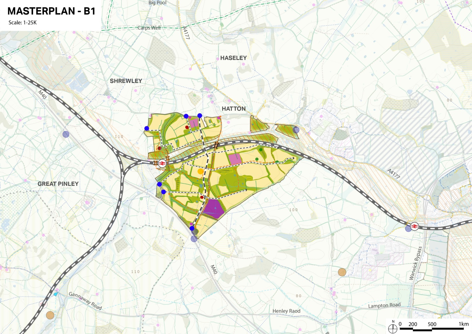
In the Plan period to 2050 land within this allocation will be developed broadly in accordance with the indicative Illustrative Concept Plan above to deliver:
- A minimum of 4,558 new homes, 4,000 of which will be delivered within the plan period to 2050. Up to 5,250 homes may be delivered depending on further masterplanning.
- Affordable housing provision in accordance with SWLP Policies, the Strategic Housing Market Assessment and SWLP Annex B or any successor documents.
- Two three forms of entry primary schools. One six-form of entry secondary school.
- Provision of one district centre and three neighbourhood centres (as indicated in the broad locations on the illustrative concept plan) to deliver retail, food and drink establishments, healthcare provision, community facilities, a library, other local services/amenities, mobility hubs and workspace opportunities.
- A minimum of 2ha of local employment provision within the district or neighbourhood centres, the expansion of the Hatton Technology Park and/or additional employment land provided at Hatton Country World.
- Enhanced and expanded Hatton Country World facilities around a District Centre.
- A new spine access road through the site including construction of a new bridge to traverse the railway line and canal, with provision for buses, segregated cycleways and segregated footways.
- A comprehensive package of strategic and local infrastructure as set out in this policy and the Infrastructure Delivery Plan, including significant on and off-site improvements to rail, sustainable and active travel infrastructure and highways.
- Primary healthcare facilities to meet the needs of the development as it expands.
- A comprehensive network of integrated green and blue infrastructure with provision of a minimum of 25ha of public open space in accordance with Council requirements.
- Sports provision in accordance with the latest Playing Pitch Strategy and Indoor Sports Facilities studies, but as a minimum provision is expected to include one leisure centre (located in central core area).
- Two adult football pitches.
- Three youth football pitches.
- Three mini soccer pitches.
- One rugby union pitch.
- One cricket pitch.
- Provision for self and custom build homes in accordance with policy HO.12.
Vision and Key Principles
The strategic allocation of this new settlement will deliver at least 4,558 homes together with a comprehensive package of infrastructure and facilities to deliver an exemplar new community with sustainable transport infrastructure at its heart. Providing an appropriate mix and size of dwellings in accordance with SWLP polices, specifically Policy DS.4 in respect of affordable housing. The development will provide a mix of homes, employment, education, retail, leisure, and community facilities, delivered across three phases between approximately 2032/33 and beyond the plan period to 2056/7.
The following key principles will underpin the design and development of Hatton New Settlement. It will:
- Be shaped by a comprehensive masterplan which will set a vision for a distinctive townscape based around a concept of three distinct but interlinked character areas. It will establish a sense of place at the outset influenced by local character and maximising existing natural assets such as the Grand Union Canal and Conservation Area.
- Maximise the sustainability of the location by significantly enhancing the rail facilities at Hatton Station and links to Warwick Parkway Station through a series of improvements to existing infrastructure and provision of new infrastructure to serve the railway.
- Be designed to provide a high degree of self-containment and self-sufficiency regarding transport, active travel, education, healthcare, community, and green infrastructure. Infrastructure and facilities must be provided at the same pace as residential development to ensure the needs of residents are met at each stage of development. Be shaped by the 20-minute walkable neighbourhood concept where most daily needs can be met within a short active travel trip with car use minimised. A range of new facilities for new residents will be provided at an early stage of the development to help establish sustainable and active travel habits.
- Incorporate an Active Travel Strategy that will integrate an active travel network with a comprehensive network of accessible, usable and attractive green and blue infrastructure and open spaces which will be at the heart of the Hatton community.
The preferred delivery model is for a master developer to oversee the comprehensive and strategically planned delivery of the site.
Phasing and Summary of Key Infrastructure Requirements
The development will be delivered in three phases, with the delivery of new infrastructure provision and improvements to existing infrastructure coordinated with development of each phase and delivered in advance of or alongside development, rather than retrospectively.
The triggers and phasing for the delivery of new infrastructure and improvements to existing infrastructure will be set out in the Infrastructure Delivery Plan (or any successor document). Key infrastructure will be provided on-site with off-site mitigation measures delivered through pooled S106 contributions in coordination with key stakeholders.
The development is intended to be phased as follows providing key trigger points:
Phase 1 – Northern Hatton and Canal Paddock – 1,550 dwellings (to be delivered from 2032-2040) to deliver:
- One three form of entry primary school and nursery, including the relocation of Ferncumbe School.
- Neighbourhood centre around the primary school.
- Neighbourhood centre to the north of Hatton station, including community mobility hub retail provision, food/drink establishments and satellite health facilities.
- A car park to serve Hatton Station and a new foot and cycle bridge over the canal to provide access to the station from phase 1.
- On and off-site highways infrastructure improvements and a realigned and improved Dark Lane.
Phase 2 – Central and Hatton South – 1,885 dwellings (2036-2046) to deliver:
- One three form of entry primary school and nursery.
- One six form of entry secondary school including sixth form provision.
- This should take the form of a combined ‘all through’ school to include a nursery, primary school, secondary school and sixth form, should this be required by the relevant education providers at that time.
- Neighbourhood centre around the secondary school.
- Part of the central core District Centre area including community mobility hubs, retail provision, food/drink and dining facilities, leisure centre and multi-service healthcare facilities.
- New Dark Lane spine road including a new bridge over the canal and railway.
- Integration with facilities at Hatton Country World.
Phase 3 – Southern & Eastern Hatton – 1,815 dwellings (2043-2056/7) to deliver:
- Remainder of central District Centre core area, retail provision, primary healthcare provision, food/drink and dining facilities.
- Safeguarded land for a potential new primary school, depending on an up-to-date assessment of capacity within the local area.
Development proposals will be required to contribute to the West of Warwick Sustainable Transport Corridor improving connections to Warwick via Warwick Parkway in accordance with SWLP Policy ID.5.
Urban Design Principles
- A master developer must set an overall placemaking vision and overarching design principles for the new settlement to ensure consistent and complementary high-quality development across the site which delivers a characterful and distinctive sense of place.
A comprehensive Hatton New Settlement Masterplan and Design Codes will be produced, which is to be approved by the Local Planning Authority, broadly having regard to the Illustrative Concept Plan (Figure xx). All development will be designed and built in accordance with this Masterplan. Existing natural assets such as the Grand Union Canal and Conservation Area will be maximised and enhanced.
- Proposals will be expected to demonstrate how they have accounted for the strategic design principles set out in Policy DS.19.
- Development blocks will be expected to deliver minimum densities of 40 dwellings per hectare. Higher densities will be considered appropriate within neighbourhood centres and key community facilities including at Hatton Station.
- Active frontages will be provided in the neighbourhood centre and district centres.
- Development will be expected to be designed in line with the recommendations set out in the SWLP Landscape Assessment, the SWLP Heritage Assessment and the Warwickshire Landscape Guidelines. This will include excluding land from development on the most elevated parts of the site (as broadly indicated on the illustrative concept plan and to the east of Hatton Country World); maintaining key views from the site towards Warwick and St Mary’s Church; and respecting the setting of the Canal Conservation Area. Proposals will be expected to protect and enhance the woodland habitats within and adjacent to the site including copses, ancient woodlands and in-field trees.
- Active travel will be integral to the development embedding the 20-minute neighbourhood concept, where daily needs can be met by active or sustainable travel.
- The Masterplan should prioritise sustainable travel modes over private car use with streets, facilities and connections designed to make walking, cycling, and public transport the easiest and most attractive modes.
Active Travel Requirements
The Hatton Masterplan will be informed by an Active and Sustainable Travel Strategy that will be based on reducing dependency on private cars, creating walkable neighbourhoods connected by safe and attractive walking and cycling routes, connected to employment and services by excellent public transport links.
The Strategy will provide an active travel network designed around new community mobility hubs. Active Travel measures will be integrated with a comprehensive network of new and enhanced green and blue infrastructure and open spaces to encourage healthy, active lifestyles.
Active travel provision will include, but is not limited to:
- Provision of four new community mobility hubs at accessible locations in each phase, in each of the three neighbourhood centres and in the district centre.
- Community mobility hubs will bring together multiple sustainable transport modes, such as buses, demand responsive transport, shared cars, rentable bikes and e-scooters together with facilities such as EV charging, secure cycle parking and parcel lockers. The mobility hubs in the north and central phases will include public spaces with seating, landscaping, community facilities and local amenities. The mobility hub in the phase 1 neighbourhood centre will include a bus interchange to serve Hatton Station.
- In phase 1, delivery of a new foot and cycle bridge over the Grand Union Canal connecting the new neighbourhood centre with Hatton Station to provide access for residents of phase 1 and surrounding rural areas to the north.
- In phase 2, developer contributions to deliver a new steps free access footbridge across the railway with lifts connecting the station with a new station entrance to the south providing access to existing residents and residents of phases 2 and 3.
- Developer contributions towards the provision of a new Active Travel link east of Hatton station in phase 2.
- Enhancements to the existing underpass under the railway and canal to provide a pedestrian and cycle link to the new active travel link east of Hatton Station.
- Provision of an east–west Active Travel corridor through a canal side park linking to an enhanced towpath to enable onward travel to the west and east.
- Developer contributions towards the delivery of significant improvements to the Grand Union Canal towpath to facilitate access between Hatton Station, Hatton Locks and Warwick Parkway Station, including new connections to the towpath.
- Conversion of Dark Lane (between canal and Hockley Road) to a walking & cycling route.
- Developer contributions towards the delivery of cycleways along the B4439 Hockley Road and A4177 Birmingham Road towards Warwick Parkway, Warwick, and Leamington Spa.
- Provision of pedestrian and cycleway linkages across the site to provide north-south and east-west connectivity intersecting development parcels to provide access to key facilities. This includes active travel provision as part of the new spine road and new pedestrian and cycle links to access the enhanced Hatton Station.
- Retention and enhancement of public rights of way crossing the site including W81, W82, W193, W76 (and variants).
Sustainable Travel Requirements
A Sustainable Transport Strategy will be based on reducing dependency on private cars, creating walkable neighbourhoods with the provision of safe and attractive walking and cycling routes, connected to employment and services by public transport. Significant improvements to rail provision and new bus infrastructure will be delivered.
Rail
The implementation of strategic plans by rail operators will increase capacity at Hatton Station meaning the station, together with Warwick Parkway, will have the capacity to accommodate the anticipated passenger growth from Hatton new settlement. This will require significant upgrades to Hatton Station in terms of access and facilities and an increased frequency of service which the new development must contribute to through a combination of:
- On-site measures as set out in this policy and the Infrastructure Delivery Plan.
- Developer contributions secured in s106 agreements (or any superseding legal agreements).
- The master-developer (or developers) working collaboratively and proactively with rail providers and relevant stakeholders including the West Midlands Rail Executive, Chiltern Railways and Network Rail.
The development will deliver:
- The following on-site:
- Active travel routes as set out above, including the new pedestrian and cycle bridge over the canal between the neighbourhood centre in phase 1 and the station; together with an east-west canal side active travel corridor making active travel the primary way to access the station.
- A new car park and bus interchange to serve the station in the phase 1 neighbourhood centre mobility hub to enable station access via the new bridge.
- Enhancements to the existing underpass under the railway and canal to connect to a new active travel link east of Hatton Station. The existing route will be upgraded to a designated public right of way.
- Together with developer contributions and partnership working to provide the following measures off-site:
- Securing a bus service to Hatton Station in phase 1and routing buses to the new neighbourhood centre bus interchange rather than Station Approach.
- Delivery of a new station pedestrian entrance from Ash Close or Antrobus Close to include a steps-free access footbridge, via either extension and improvement of the existing bridge or its replacement.
- Improvements to the existing road railway bridge on Station Road, for example signal control if required by highways providers.
- Improved access. waiting areas, signage and welfare facilities.
- Provision of a new active travel link east of Hatton Station on Network Rail land, delivered as part of Phase 2 and connecting to the enhanced underpass.
- Enhancements to the canal towpath to connect the on-site east-west active travel route onwards towards Warwick Parkway and Warwick.
- Car park charging and residents permit parking scheme in the vicinity of the station, if required.
- Additional, secure cycle parking at Hatton and Warwick Parkway stations.
- The potential use of Hatton Loop for rail delivery of construction materials for later phases.
- The increased frequency of rail services must occur early in the development phasing
Bus
The following measures to ensure the new settlement is well served by bus will be delivered:
- A high frequency bus service from first occupation, connecting Hatton new settlement with Warwick Parkway, Warwick, and Leamington Spa secured via Level of Service Agreement.
- A bus interchange in the phase 1 neighbourhood centre mobility hub to provide a bus service to Hatton Station.
- High quality bus stops with shelters, seating, raised kerbs and real-time information within easy reach of all homes.
- Bus priority measures within the site and at key junctions with existing highways (if feasible).
Access and Highways Requirements
- The following highways infrastructure will be directly delivered by the development on or adjacent to the site:
- A new junction onto the B4439 Hockley Road (eastern) connecting to a realigned Dark Lane which will be the primary vehicular access for the site, likely to be via a new signalised junction.
- A new junction onto the B4439 Hockley Road (western) which will be the secondary vehicular access for the site, likely to be via a ghost island.
- A series of improvements to Dark Lane including but not limited to:
- In phase 1:
- Realignment of Dark Lane with a new bridge over the canal to provide a wider, enhanced route within the site to provide access to early phases.
- In phase 2:
- Construction of a new Dark Lane, an ‘all traffic’ spine route from Hockley Road through the site, with integrated pedestrian and cycleway provision, linking to Station Road (south of the M40) as per the illustrative Concept Plan
- This will require a new bridge over the railway line and Grand Union Canal which will require proactive early engagement with relevant stakeholders such as Network Rail and the Canal & Rivers Trust.
- The existing Dark Lane railway bridge and road downgraded to a walking and cycling route between the Grand Union Canal and Hockley Road, with vehicle access retained only for existing properties.
In addition, significant mitigation measures to the nearby local and strategic highways network will be required. Measures will be provided through developer contributions (with the costs apportioned according to impact) with the masterdeveloper (or developers) working proactively with highways providers and relevant stakeholders. Improvements will include, but are not limited to:
- Capacity improvements at A46/A425/A4177 Stanks Island.
- Capacity improvements at M40 J15.
- Capacity & safety improvements at A4177 Birmingham Road / B4439 Hockley Road junction.
- Upgrade of Dark Lane / Henley Road junction.
- Widening of Dark Lane south of the M40 to enable improved two-way movement.
- Capacity improvements at A4177 Birmingham Road / Old Budbrooke Road junction.
- Triggers and phasing will be set out in the Infrastructure Delivery Plan.
Education Requirements
New educational facilities (nursery, primary, secondary, Special Resource Provision facilities and Post 16 facilities) to ensure that provision matches the full needs arising from the development at the same time as the settlement’s population grows.
The development will deliver:
- Two new primary schools and a secondary school as detailed below.
- A new three form of entry primary school and nursery in phase one in the broad location shown on the illustrative concept plan. This school will incorporate relocating the existing Ferncumbe CofE School from Hatton Green.
- The primary school will be part of the neighbourhood centre in the northern development parcel and will be sited adjacent to the mobility hub which will include a new community building(s) to provide activities associated with the school, for example before and after school clubs.
- A new six form of entry secondary school with sixth form provision in phase 2, in the approximate location shown on the illustrative concept plan.
- This may comprise an ‘all through’ school, with provision for a nursery, a three form of entry primary school, and a secondary school on a single site should this align with needs data and the requirements of relevant education providers at that time.
- Provision of a direct bus route(s) to serve the secondary school to reduce parent drop-offs by private car.
- Alternatively, if an ‘all through’ school is not provided in phase 2 a new three form of entry primary school will be provided in phase 2 in the district centre, in the broad location shown on the illustrative concept plan.
- Additionally, land will be safeguarded in phase 3 for the provision for a further primary school, should an up-to-date assessment of capacity within the local area at that time demonstrate sufficient need. If an additional school is not needed at that time the land will instead be provided as public open space. Triggers and phasing will be set out in the Infrastructure Delivery Plan.
Healthcare Requirements
- Provision of medical and healthcare facilities as and when these are required by the Primary Care Trust or the Integrated Care Board, based upon the proportionate needs arising each stage of the development.
- Healthcare facilities will be provided early in phase 1 to ensure impact on existing facilities in the local area is mitigated.
- Facilities will be located in the local or district centres and will include primary care provision such as GP surgeries or satellites, pharmacies and dentists.
- Early engagement with providers has indicated preference for a satellite primary care facility in phase 1 with a larger new health hub facility in the district centre in phase 2/3. The master developer (or developers) will continue to engage proactively with providers to ensure healthcare facilities are delivered in a strategic and co-ordinated way as the development progresses.
Public Open Space and Sports provision requirements
- Delivery of public open space in accordance with the requirements and levels of provision set out in Public Open Space SPD or successor documents or evidence. This will include the following provision:
- Parks and gardens including three new parks (covering approximately 25ha) to ensure that all residents of the development are within a five-minute walk of green space.
- Provision of an appropriate range of fully equipped play spaces for children of all ages, in accordance with the following hierarchy of play provision:
- Local Areas of Play (LAPs).
- Local Equipped Areas of Play (LEAPs).
- Neighbourhood Equipped Areas for Play (NEAPs). Multi-Use Games Areas (MUGAs).
- Facilities will be provided in accessible locations with good natural surveillance.
- Natural areas including urban woodland.
- Allotments/orchards/community gardens.
- Informal recreation and picnic areas.
- Creation of green corridors as part of the active travel network.
- Delivery of sports facilities in line with the recommendations set out in the latest published Playing Pitch Strategy and Indoor Sport Facilities Strategy.
- As a minimum provision will include:
- One leisure centre
- Two adult football pitches, including one 3G pitch adjacent to the leisure centre
- Three youth football pitches
- Three mini soccer pitches
- One rugby union pitch, within a sports club environment or allocated to a local club
- One cricket pitch within a sports club environment or allocated to a local club
- The pitch provision will include associated changing rooms and ancillary facilities.
Biodiversity and Green & Blue Infrastructure requirements
- The development will deliver a comprehensive network of green and blue infrastructure spaces and corridors, based on the landscape character of the site, which will enhance the attractiveness of the development and sustain a sense of place, promote a sense of community and social interaction among residents and encourage health and well-being.
- Development will be required to retain, enhance and incorporate existing natural assets including the Grand Union Canal and valuable habitats such as ancient woodland, hedgerows, ponds and veteran, ancient or mature trees.
- The development should be designed to align with the recommendations set out in the latest published Ecological Assessment, Landscape Assessment and/or other evidence supporting the SWLP.
- New green infrastructure will link to adjacent networks and public rights of way wherever possible.
- The development will be required to deliver a minimum of 10% biodiversity net gain, as agreed with the Warwickshire County Council Ecology and Warwick District Council Green Spaces teams.
- The delivery of green infrastructure will include an appropriate strategy for the long-term stewardship and management of the provision.
Environmental Health Requirements
- Provision of adequate noise mitigation measures to mitigate impacts of the railway and M40 motorway.
- Provision of adequate air quality mitigation measures to mitigate impacts from the railway, M40 motorway and any other potential sources of air pollution.
- The development will need to be designed to protect the amenity of residents by considering potential impacts of neighbouring land uses (such as employment land, sports and leisure facilities etc) and impacts such as potential noise, light and air pollution.
Historic Environment Requirements
- Development will be expected to be designed and delivered in line with the recommendations set out in the SWLP Landscape Assessment and SWLP Heritage Assessment. This includes minimising the harm to the setting and significance of the Canal Conservation Area, as well as listed buildings within the site, and in relative proximity, to the site.
- Development will be expected to make suitable provision for the consideration of archaeology with investigations as required and provision of mitigating measures if required. These investigations may be required prior to planning applications.
Flood Risk, Drainage and Water Supply
No built development will be permitted in any part of the areas of the site which fall within Flood Zones 2 and 3.
The development will be the subject of a comprehensive Flood Risk Assessment and Drainage Strategy which will:
- Address areas at risk of ground and surface water flooding;
- Integrate sustainable surface water management through the site throughout the lifetime of the development;
- Identify opportunities for floodwater storage through the provision of sustainable urban drainage systems (’SuDs’), such as swales, detention basins, and permeable paving, to store and infiltrate runoff, reducing surface water entering sewer systems. Wherever possible these should be integrated with green and blue infrastructure and the public realm; and
- Engage with local organisations such as wildlife trusts, canal and rivers trusts and catchment partnerships to seek opportunities for flood risk mitigation and environmental betterment.
- Early and ongoing engagement with water supply and sewage treatment providers to ensure capacity for each phase of the development is available and planned in a strategic way.
8.2 Proposal LMA - Long Marston Airfield New Community
Proposal LMA (Site Proposal) ~ Requirements
Long Marston Airfield New Community
Location
HELAA references: 37, 74, 141, 146, 175, 262, 310, 333, 355, 707, 832, 908, 910, 919, 940
Site Size
697 ha
A. Key Development and Land Use Requirements
Development Needs
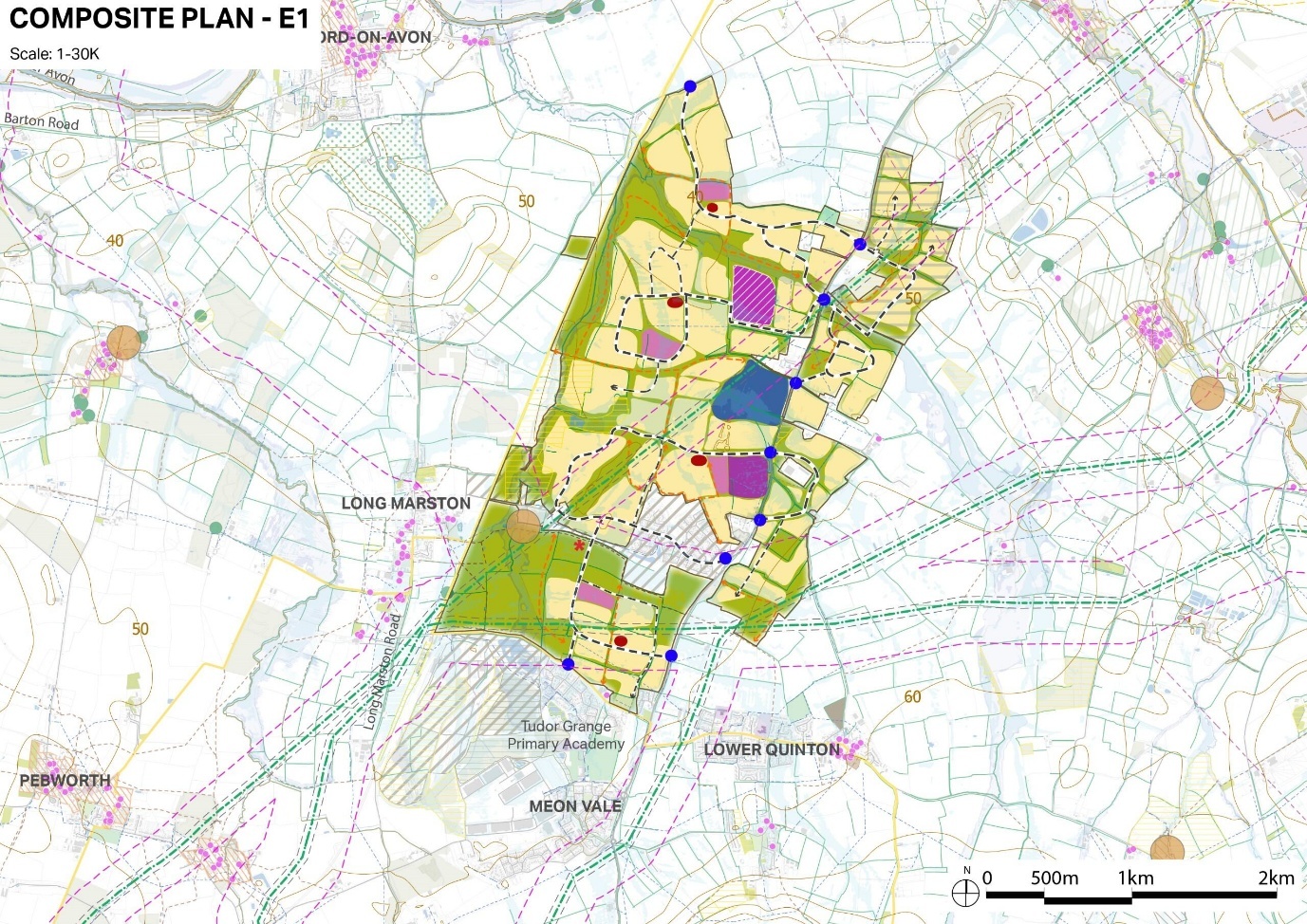
- Minimum of 10,300 new homes, with a at least 4,500 built by 2050
- 15 hectares of non-strategic employment land
- 21 pitches for Gypsies and Travellers across at least 2 sites
Affordable Housing
- Delivery of affordable housing provision in accordance with Policy DS.4
Education Infrastructure
- 4 x 3-form entry primary schools
- 1 x Secondary School
- Land reserved for second secondary school
Neighbourhood Centres
- 13.4 ha mixed use development areas
- 1 district centre and 3 local centres, incorporating convenience retail, employment, health and community facilities
- Provision of and/or contribution to community facilities such as community buildings and sports facilities (in line with the requirements set out in the latest available Playing Pitch Strategy and Sports Facilities Assessments.)
Open Space
- Sports provision in accordance with the latest Playing Pitch Strategy and Indoor Sports Facilities studies
- Delivery of continuous green and blue infrastructure corridors linking to adjacent networks and utilising existing and potential habitats and historic landscape, in particular retention and enhancement of hedgerows and hedgerow trees, and networks
- Delivery of public open space in accordance with the requirements set out in Policy ID.15. Including provision of a Country Park.
- A network of multi-functional green spaces, including links to the Greenway, provision of a new Country Park (HELAA ref 146)
Active Travel
- Transport hub and safeguarded land for railway station
- Provision of on-site bus infrastructure and contributions to deliver frequent bus services to serve the new settlement. Provision of pedestrian and cycleway linkages across the site to provide north-south and east-west connectivity intersecting the strategic site, and between and across sub-parcels to provide access to key facilities.
- Active travel links to the sports and community facilities at Meon Vale.
Transport
- Delivery of highway improvements and financial contributions in accordance with the requirements set out within the Strategic Transport Assessment or Infrastructure Delivery Plan.
- Contributions to provision of a Western Bypass in accordance with Policy ID.4
Energy
- A Solar Farm (HELAA site reference 355), with the site being brought forward for housing when available.
B. Timescale
Phase 1A (124 dwellings) and Phase 1B (376 dwellings and serviced parcel of land for a Primary School) at HELAA Ref 310) to be delivered early in the plan period and are not dependent on the provision of the Stratford upon Avon Bypass.
Delivery of development across the wider site would commence following opening of the Stratford-upon-Avon Bypass (anticipated in 2035), or sooner if it can be demonstrated to the satisfaction of the Highways Authority that additional development can take place in advance of the Bypass being delivered.
Phasing to ensure delivery of the core part of the site, (HELAA site reference 310) associated community facilities, including a new Secondary School.
C. Infrastructure Funding Requirements
Anticipated infrastructure and associated costs are set out in the Infrastructure Delivery Schedule for the site. Stratford on Avon District Council (and its successor) will work with Homes England and the site promoters to identify and secure appropriate funding sources for the delivery of the Stratford-upon-Avon Bypass.
D. Urban Design Principles
- A consolidated Masterplan must be prepared for the whole of the allocated site.
- Proposals will be expected to demonstrate how they have accounted for the strategic design principles set out in Policies DS.18 and DS.19
- Proposals will be expected to follow the 20-minute neighbourhood concept where most daily needs can be met within a short active travel trip with car use minimised.
- Development blocks will be expected to deliver minimum densities of 40 dwellings per hectare (net). Higher densities will be considered appropriate within areas identified for neighbourhood centres and key community facilities.
- The development should be designed to deliver active frontages in the areas identified for neighbourhood centres.
- Development will be expected to be designed and delivered in line with the recommendations set out in the SWLP Landscape Assessment and/or the Warwickshire Landscape Guidelines. In particular development should:
- Ensure new development does not appear intrusive in views towards the Cotswolds National Landscape (particularly views to Meon Hill), recognising that the site makes a limited contribution to its wider setting. Landscaping should be used to help break up the built up area as viewed from the Cotswold National Landscape
- Conserve and enhance the areas of deciduous woodland around Meon Vale, including those designated as LWS or potential LWS, by providing appropriate buffer zones.
- Respect the open, undeveloped skylines in the northern and central parts of the site, ensuring building height, massing, and layout do not introduce prominent built form into the currently open views.
E. Active Travel Requirements
The consolidated Masterplan should demonstrate how active travel opportunities will be provided to enable travel throughout the new settlement, including access to Meon Vale.
Retain and protect the Monarch’s Way and Heart of England Way promoted routes which cross the south of the site. Ensure that the paths remain open, safe, and retain their rural character.
Provide further areas of public access within the site where possible, linking to the existing PRoW network, including the Greenway.
F. Access, Highways and Public Transport Requirements
Contribute towards provision of the Stratford-upon-Avon Bypass in accordance with Policy ID.4.
Demonstrate safe vehicular access from the Campden Road, Station Road and Milcote Road, ensuring that proposals do not create potential conflicts with adjoining sites within the allocation.
Provide mobility hubs in appropriate locations to help provide transport choice.
Contribute to highway network improvements on the wider road network, required in compliance with Policy BN.16 to identify any opportunities to address existing road safety issues in the wider road network.
Contribute towards public transport improvements and connections including:
- Improvements to existing bus services to Stratford-upon-Avon and other settlements.
- Safeguarding of land for a Railway Station
- Safeguarding of the Greenway for restoration of a heavy rail line between Honeybourne and Stratford-upon-Avon
G. Environmental Health Requirements
Ensure that development is appropriately located so as to avoid impacting on the operations of the Long Marston Water Treatment Works.
Light pollution/light spill should be minimised to help avoid significant effects on the setting of the Cotswolds National Landscape.
H. Historic Environment Requirements
A buffer at the western edge of the site must be provided to help preserve the setting of heritage assets within and on the periphery of Long Marston Village.
A buffer to the listed building (Long Marston Grounds) to the southeast of the site consisting of open space or planting must be provided within the Site.
Retention of best preserved areas of ridge and furrow and dew ponds as part of green space within the development wherever possible.
Any development should be preceded by archaeological investigations to protect and record any undiscovered buried heritage.
I. Flood Risk, Drainage and Water Supply
Most of the site is located within Flood 1, with some minor areas of flood zone 3 associated with Gran Brook and Marchfront Brook. Development will be required to ensure that the developable area is directed towards the most suitable locations, avoiding areas of risk and using SuDS to ensure that there is no worsening of downstream effects as a result of the development.
The site is underlain by Blue Lias Formation and Charmouth Mudstone Formation Mudstone, which has low potential for infiltration as a surface water disposal method. Areas of surface water flood risk must be dealt with holistically through appropriate master planning, using attenuation basins, swales and flood meadow creation to ensure appropriate, controlled discharge.
Easements will be required along the watercourses within the site, which ideally should be free of all development. The widths of the watercourse easements will need to be agreed with the Lead Local Flood Authority (LLFA), considering the size of the watercourses, their typical flows and their maintenance requirements.
J. Climate Change
HELAA Site reference 355 has an extant planning permission for a solar farm but is anticipated to revert to housing once the lease for the solar farm expires.
K. Biodiversity and Green & Blue Infrastructure
Development of this new settlement could result in the loss of key habitats including woodland. Proposals should demonstrate the delivery of Biodiversity Net Gain above the minimum 10% to support the expansion of the priority habitat within the site.
Development should be focused on areas of arable and previously developed land to allow for the retention of the habitats of the most ecological importance, namely Priority Woodland, hedgerows and mature trees, streams and ponds, and semi-improved grassland.
Proposals should seek to retain and enhance onsite hedgerows and mature trees within the design.
Linked up blue and green infrastructure should be provided throughout the Site through strategic enhancements of the onsite stream and hedgerow networks to ensure the retention and enhancement of optimal habitat for water vole and otter, and foraging and commuting bats throughout the local area.
Provisions for protected and priority species should be incorporated into the design of the development, including ecologically designed sustainable drainage systems (SuDS) and hibernacula for amphibians, invertebrates and reptiles, and roosting/nesting boxes for bats and birds.
L. Public Open Space
Public open space will be provided across the site in accordance with Policy ID.15.
This should be delivered through a range of different formal and informal uses including areas of play, allotments, community orchards, meadows, and sports pitches and a Country Park.
The exact provision of sports pitches will be in accordance with the Playing Pitch Strategy and Indoor Sports Facilities Study.
M. Other Constraints
The development will demonstrate a clear strategy for responding to the National Gas Transmission high-pressure gas pipelines present within the site which provides evidence on how the National Gas Transmission Design Guide and Principles have been applied at the masterplanning stage and how the impact of the assets has been reduced through good design.
8.3 Proposal BID.1 - Bidford-on-Avon
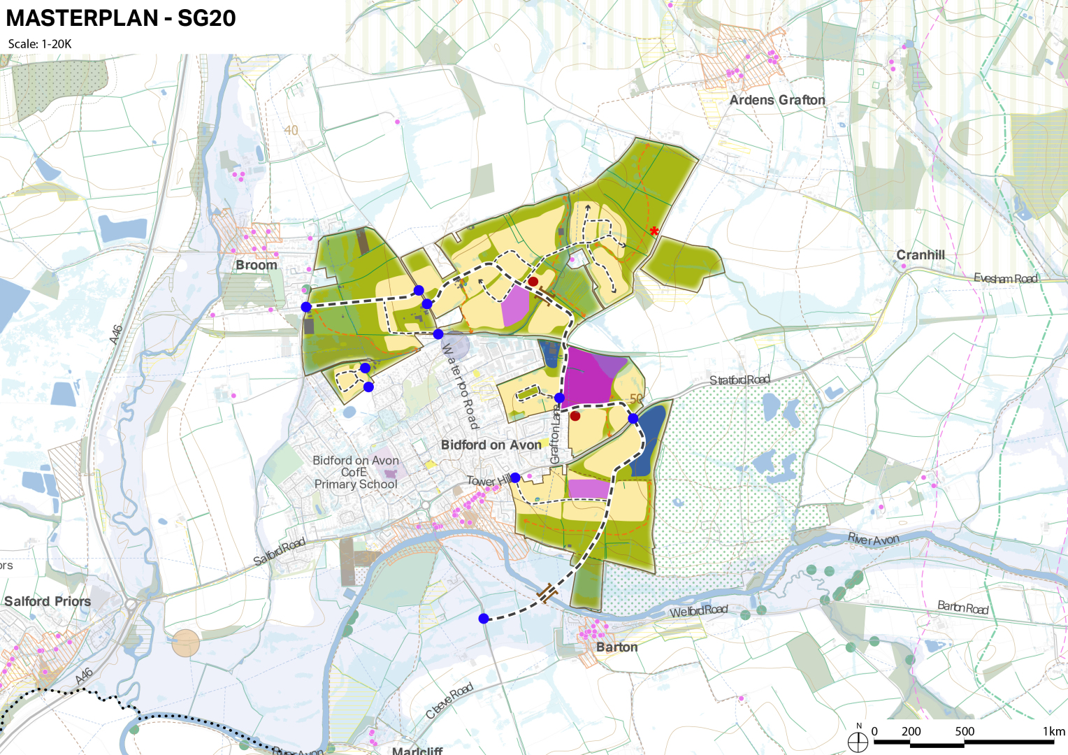
Proposal BID.1 (Site Proposal) ~ Requirements
Bidford-on-Avon Land to North and East
Location
Land North and East of Bidford-on-Avon
Site Size
221 / 217.7 hectares (non-green belt)
Summary
The vision for Land North and East of Bidford is to deliver a mixed-use urban extension to Bidford-on-Avon within the Local Plan period. This development will comprise a minimum of 2,225 dwellings, the provision of two primary schools, an early years facility, land for a secondary school, a Local Centre, employment land, a discount food retailer, along with care, assisted living, and retirement facilities. A link road between the southeast of the site and the Honeybourne Road, which will also provide a crossing over the River Avon. The urban extension will also provide associated infrastructure including Sustainable Urban Drainage Systems (SuDS), public open space, and active travel links. The scheme will respect the natural pattern of topography towards the River Avon to the south of the site, and open space has been purposely positioned in a way which maintains a green gap between Bidford-on-Avon, and the neighbouring settlement of Broom. SuDS, public open space, and active travel links. The scheme will respect the natural pattern of topography towards the River Avon to the south of the site, and open space has been purposely positioned in a way which maintains a green gap between Bidford-on-Avon, and the neighbouring settlement of Broom.
Timescale
From 2033 to 2050
Key Development and Land Use Requirements
- Housing:
- The delivery of a minimum of 2,225 homes in the period up to 2050 comprised of a mixture of sizes and types of dwellings in line with the latest Strategic Housing Market Assessment (SHMA)
- Provision of affordable housing in accordance with Policy DS.4
- Care home / assisted living facilities / retirement homes.
- 8 pitches for Gypsies and Travellers
- Education: The provision of land for a primary school, a secondary school, and an early years facility
- Community facilities:
- Local Centre comprising a Convenience Store, and other retail outlets
- Employment:
- 11 hectares of employment / light industrial research and development land required
Green Infrastructure:
- Attenuation basins within the low-lying areas of the Site
- Open space positioned at the development edges, particularly towards the northwest of the site in order to preserve Broom’s identity as a separate settlement
- Tree lined primary movement corridor proposed
- Public Right of Way and cycle links
- Children’s Play Areas positioned to be within walking distance of all homes.
- Access: Three access points proposed on the Site.
Infrastructure Funding Requirements
The scheme will be expected to comply with local and national policies relating to infrastructure contributions. The developer has indicated that the below contributions will be made.
On site contributions:
- Two new primary schools
- Land for a new secondary school
- Direct links into village centre
- A variety of public open spaces
- Early years facility
- Local health facility or contribution towards expansion of existing facilities
- A variety of public open spaces and children’s play area
- Active travel connections linking to existing non-car routes within the built-up area
- On site BNG contributions
Off-site contributions:
- Education and healthcare contributions, aligned with local needs
- Integration with wider Biodiversity Net Gain (BNG) initiatives
Urban Design Principles
Masterplanning of the scheme will need to accord with local and national design policies and guidance. The design of the scheme will also need to be informed by a site-specific design code.
Urban design should be guided by the ethos of creating a sustainable mixed-use development to the community of Bidford-on-Avon, whilst minimising landscape impacts to the surrounding area, along with ensuring that any amenity impacts on existing residents are sufficiently mitigated.
A site-wide masterplan, providing key design principles, must be prepared and agreed upon with SDC prior to the submission of any planning application.
Bidford-on-Avon is categorised as a Main Rural Centre. There is already a need for local services in the existing settlement, and masterplanning of BID.1 must demonstrate that proposed new services will be accessible to residents of both the site, and the wider settlement. The site spans as far north as the nearby settlement of Broom which, while closely related to Bidford-on-Avon, is clearly a distinct settlement, and the importance of preventing Bidford-on-Avon from merging with Broom must be reflected in the masterplanning of the scheme. the masterplanning of the scheme.
Some landscape sensitivity is noted, and the residential aspect of the scheme should be concentrated within the central parts of the site, and open space directed towards the edges, in order to limit impacts on the surrounding landscape.
The masterplan will be expected to demonstrate several key aspects of the approach, such as being landscape-led, and ensuring the scheme promotes pedestrian links both around the site, and between the site and the existing settlement. The masterplan should also be able to demonstrate that existing PRoWs have been preserved and enhanced, along with ensuring that the proposed public open space is as accessible to all residents of the urban extension as reasonably possible.
Active Travel Requirements
The scheme will be required to make provisions for active transport infrastructure which accords with local and national active and sustainable transport policies and guidance. It is essential that the masterplanning of the scheme prioritises sustainable and active transport wherever possible, with an aim of limiting private vehicle use.
The site will have regard to the principles of a 20-minute neighbourhood, where people within a settlement have access to all of the services they need within a reasonable walking distance. The benefits of walkable neighbourhoods are an important consideration when assessing the sustainability of a development proposal. With this considered, it is expected that the masterplanning of this scheme will ensure that it is as walkable as reasonably practicable.
Enabling and enhancing accessibility for existing and future residents is a key objective for any proposals, and the entire site must have a strong network of active travel connections internally within the scheme, to the existing Bidford-on-Avon, and with the neighbouring settlement of Broom. Transport proposals within the site must prioritise pedestrian movement.
The scheme’s proposed should provide a primary movement corridor between Waterloo Road and Stratford Road, which will connect throughout the scheme, and will provide the main vehicular access route through the site, along with safe active transport links. Alongside this, the corridor will not connect through proposed open spaces at development edges, which themselves will prioritise pedestrian movement. The scheme will also provide links between the site, and future LCWIP proposals of the old railway line. The scheme will provide active transport routes along the stretches of the future LCWIP which run through the site, and will provide the stretch of the LCWIP which will link to the A46.
Access, Highways and Public Transport Requirements
Access and transport considerations are an integral aspect of good design. Any scheme which does not provide safe and sufficient access to the site, along with parking provision which accords with the recognised standards, will be unfeasible.
The development will have three vehicular accesses, one from each end of the primary movement corridor at Stratford Road and Waterloo Road respectively, and another off Waterloo Road to the northwest parcel of land which is separated from the rest of the Site by Waterloo Road.
The following highways infrastructure will be directly delivered by the development on or adjacent to the site:
- A new river crossing over the River Avon
- Land allocated for a link to the Stratford to Bidford proposed disused railway cycle path
- Partial signalisation of the A46/B439 Roundabout. Signals will be introduced on the A46 approaches from the north and south, along with the adjacent circulatory. This is intended to better balance queues predicted to form on Waterloo Road as a result of the proposals.
- Signalisation of B439/Waterloo Road T-junction. This is intended to alleviate queues expected to form on Waterloo Road as a result of the proposals.
- Delivery of a link between B439 Stratford Road, and B4085 Honeybourne Road, through BID.1. This link will include the proposed new bridge, and is intended to reduce traffic through the village centre and over the existing Bidford Bridge.
- Restriction of Bidford Bridge to a one-way system no longer allowing northbound crossing. This will help to best utilise the proposed new bridge, along with directing traffic away from the centre of Bidford.
- New link between Bidford Road/Victoria Road, and Waterloo Road. This will route through BID.1, and will form part of the vehicular access to the site. Provision of this link is intended to reduce traffic through the centre of Bidford.
- Link between Grafton Lane, and Waterloo Road. This link will route through BID.1, and is intended to direct traffic away from Bidford village centre.
Access to high quality public transport modes is critical to sustainable design. The development must connect to existing bus services. The provision of additional infrastructure to facilitate additional public transport on and near to the site, which would mitigate additional trip generation resulting from the development, would be viewed favourably.
Transport modelling for BID.1 has indicated that the existing road network within Bidford is ill-equipped to accommodate additional traffic resulting from the proposed strategic growth. Measures which reduce vehicle demand through the village centre, through both traffic calming measures to these roads, and through providing alternative routes for existing and future residents of Bidford are vital aspects of the scheme.
Environmental Health Requirements
The scheme must ensure that it minimises pollution impacts resulting from the development. The scheme will not be feasible if there are any unacceptable pollution or environmental health impacts resulting from it. Proposals must be informed by the relevant technical information to show that development is acceptable with regards to pollution and environmental health. Improvements to air, land and water quality, along with environmental health benefits will be viewed favourably. expected to provide contributions to offset the increased demand on the Bidford-on-Avon Sewage Treatment Works. expected to provide contributions to offset the increased demand on the Bidford-on-Avon Sewage Treatment Works.
Historic Environment Requirements
- Development proposals must consider their impact in relation to the following nearby heritage assets and must be sensitive to the presence of them and avoid substantial harm:
- The northeast side of the Site wraps around the Grade II Listed Famington Farm.
- Southwest of the site borders Bidford-on-Avon Conservation Area.
- Northwest of the Site overlaps with Broom Conservation Area.
- A number of Listed Buildings within the built-up areas of both Bidford-on-Avon and Broom are situated a short distance from the Site.
Flood Risk, Drainage and Water Supply
- All proposals must be prepared in accordance with local and national flood risk policies to ensure that appropriate measures are in place at Bidford-on-Avon sewage treatment works to facilitate the development's progress.
- The site is partially located within Flood Zone 2 and 3; proposals will be expected to account for this through appropriate design and SuDs application
Climate Change
- All homes will be required to engage in sustainable design and construction, including the use of renewable and low-carbon energy, in accordance with local and national policy and guidance.
Biodiversity and Green & Blue Infrastructure
Proph, east, and west edges of the site are categorised as having ‘medium’ visual sensitivity, and the south edge is considered more sensitive due to its proximity to the River Avon.
Public Open Space
- Proposals will be expected to provide public open space in accordance with the standard sets out in Policy ID.14 offering diverse typologies for recreation and amenity.
Employment
- At least 11 hectares of employment land is required.
8.4 Proposal BIT.1 -Bishop’s Tachbrook - Land to West
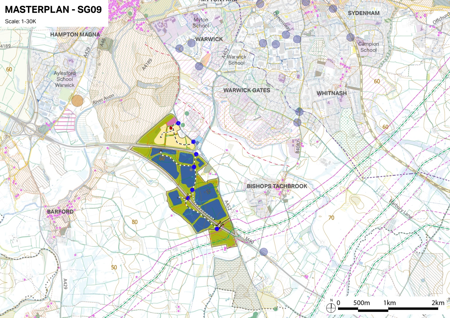
Proposal BIT.1 (Site Proposal) ~ Requirements
Land West of Bishop’s Tachbrook (Land at Park Farm)
Site Size
41.18 hectares
Summary
Land within this allocation will be developed to deliver a minimum of 655 new homes to form a new neighbourhood, including land for a new primary school, community space, local centre, and extensive green infrastructure.
Timescale
2030/31-2037-38
Key Development and Land Use Requirements
- Residential: A minimum of 655 dwellings to be delivered within the plan period.
- The housing mix will include an appropriate provision of affordable housing in accordance with policy DS.4, self-build and custom housing and other unit types to meet local needs.
- Education: The provision of 2.2ha of land with the potential to accommodate a 2 Form of Entry primary school.
- The provision of 0.15ha of land for community development, including a community hall and parking.
- The provision of 0.3ha of land for a Local Centre.
- Public open space incorporating play facilities and SuDS.
- Significant green edge buffer within the allocation boundary to maintain separation between setting of Grade 1 listed Warwick Castle parkland.
Infrastructure Funding Requirements
Education:
- Contributions will be required to ensure that there is sufficient secondary education capacity in the area to support the growth in local needs resulting from the development.
- Land will be safeguarded with the potential to provide a 2 form of entry primary school, should it be required by the relevant education providers.
Transport:
- Contributions to mitigate any adverse highways impacts identified.
Developer contributions will be required to help fund wider public transport and cycle and footway infrastructure (including a bridge across the Tachbrook and bridge across Europa Way) to link into wider Bishops Tachbrook and the existing footpath network.
Development proposals will be required to contribute to the South of Leamington Sustainable Transport Corridor improving connections to Leamington via Europa Way in accordance with SWLP Policy ID.5.
Healthcare, Education and Community Facilities:
- Contributions towards healthcare provision. Provision on site of a variety of public open spaces in line with the requirements of the local authority.
- Provision of land for a local centre and community building.
Development proposals will be required to contribute to the South of Leamington Sustainable Transport Corridor improving connections to Warwick via Warwick Parkway in accordance with SWLP Policy ID.5.
Urban Design Principles
- Compliance with the relevant housing design principles and design code policies set out in Policy DS.19, alongside site-specific requirements relating to connectivity, future road layouts and phasing, to support the creation of a sustainable neighbourhood.
- Proposals will be expected to follow the 20-minute neighbourhood concept where most daily needs can be met within a short active travel trip with car use minimised.
Development to be designed sensitively to the surrounding landscape setting and give due consideration to the setting of Grade 1 listed Warwick Castle parkland.
Active Travel Requirements
Active travel contributions will be required in association with the Asps, including contributions towards the Park and Ride scheme and the delivery of footpath, cycle and bridge connections to the north.
Cycling routes:
- New cycle infrastructure will be required, as currently there is no suitable existing strategic cycle route serving the sites.
- New cycle routes should provide connections to:
- The employment land at Red House Farm associated with BIT.2.
- Warwick and Leamington urban areas
Pedestrian routes:
Improved pedestrian connectivity will be required given:
- The scale of housing (circa 2,300 homes combined across BIT.1 and BIT.3)
- The employment land at Red House Farm associated with BIT.2.
New development will be required to deliver:
- Safe and direct walking routes between BIT.1, BIT.2 and BIT.3.
- Pedestrian links to:
- Bishop’s Tachbrook
- Local employment areas
- Public transport stops along Europa Way.
Pedestrian routes should be integrated with bus stops and cycle corridors to support sustainable travel choices.
- Requirement to integrate with Banbury Road Active Travel measures and connect into PROW network into Bishops Tachbrook and to Leamington (Tachbrook and Europa Way bridges).
Access, Highways and Public Transport Requirements
Access:
- Provision of two new access points onto Banbury Road for access to the 655 homes.
- The road immediately south of the site (A452) is proposed to be amended to a dual carriageway under the current Europa Way Corridor Programme being delivered in the current Local Plan to increase capacity and safety from the A452 M40 Junction 14 slip road.
Public Transport:
The proposals should provide bus routes within the site and connection through to the Asps and enable connections between BIT.1 and BIT.3.
Environmental Health Requirements
- A contaminated land assessment will be required to address the impacts associated with the former quarrying and landfill site to the northern part of the site, in order to enable the delivery of public open space and housing.
- Consideration is required to address noise impacts and effects on air quality arising from M40 and A452.
Historic Environment Requirements
- No historic buildings on site. However, Grade 1 Listed Warwick Castle Park lies to the northeast of the Site. A Heritage Impact Assessment and archaeological investigations will be required.
- Mitigations will include restricting development on northern part of site (to be used for green space and allotments).
Flood Risk, Drainage and Water Supply
- While the allocation is located within Flood Zone 1, development will be required to demonstrate that surface water runoff has been appropriately considered through the provision of SuDS.
- All proposals must be prepared in accordance with Policy ID.9 – Reducing Flood Risk.
Climate Change
- All homes will be required to engage in sustainable design and construction, including the use of renewable and low-carbon energy, in accordance with Policies NZ.1 - Operational Net Zero in New Residential Buildings, NZ.3 Embodied Carbon and NZ.5 Climate Resilient Design.
Biodiversity and Green & Blue Infrastructure
- Proposals should make provision for a belt of green space towards the northern boundary of the allocation to both provide a strong, defensible buffer and boundary to the Warwick Castle parkland.
- Proposals will be required to maintain and enhance, where possible, existing landscape features with biodiversity value, in particular mature trees and hedgerows.
- If this is not practicable to enable the timely and viable delivery of the development, mitigating features should be provided on-site, with a biodiversity net gain delivered in line with national policy and the relevant BNG policies laid out elsewhere in the SWLP.
Public Open Space
- Proposals will be expected to provide public open space in accordance with the standard sets out in Policy ID.14 offering diverse typologies for recreation and amenity.
- Local Equipped Areas for Play should be included responding to local needs and ensuring that all age ranges and specialist needs are catered for,
- Provision of allotments in the green buffer area to the north of the site.
- Contributions to outdoor sports provision in line with identified needs in the 025 Playing Pitch Strategy.
Other constraints
The Site falls within a Mineral Safeguarding Area, as identified in the adopted Warwickshire Minerals Local Plan 2018-2032 (July 2022). Regard must therefore be had to policies MCS 5: Safeguarding Minerals and Minerals Infrastructure and DM 10 Mineral Safeguarding.
8.5 Proposal BIT.2 - Bishop’s Tachbrook - Land to South-west
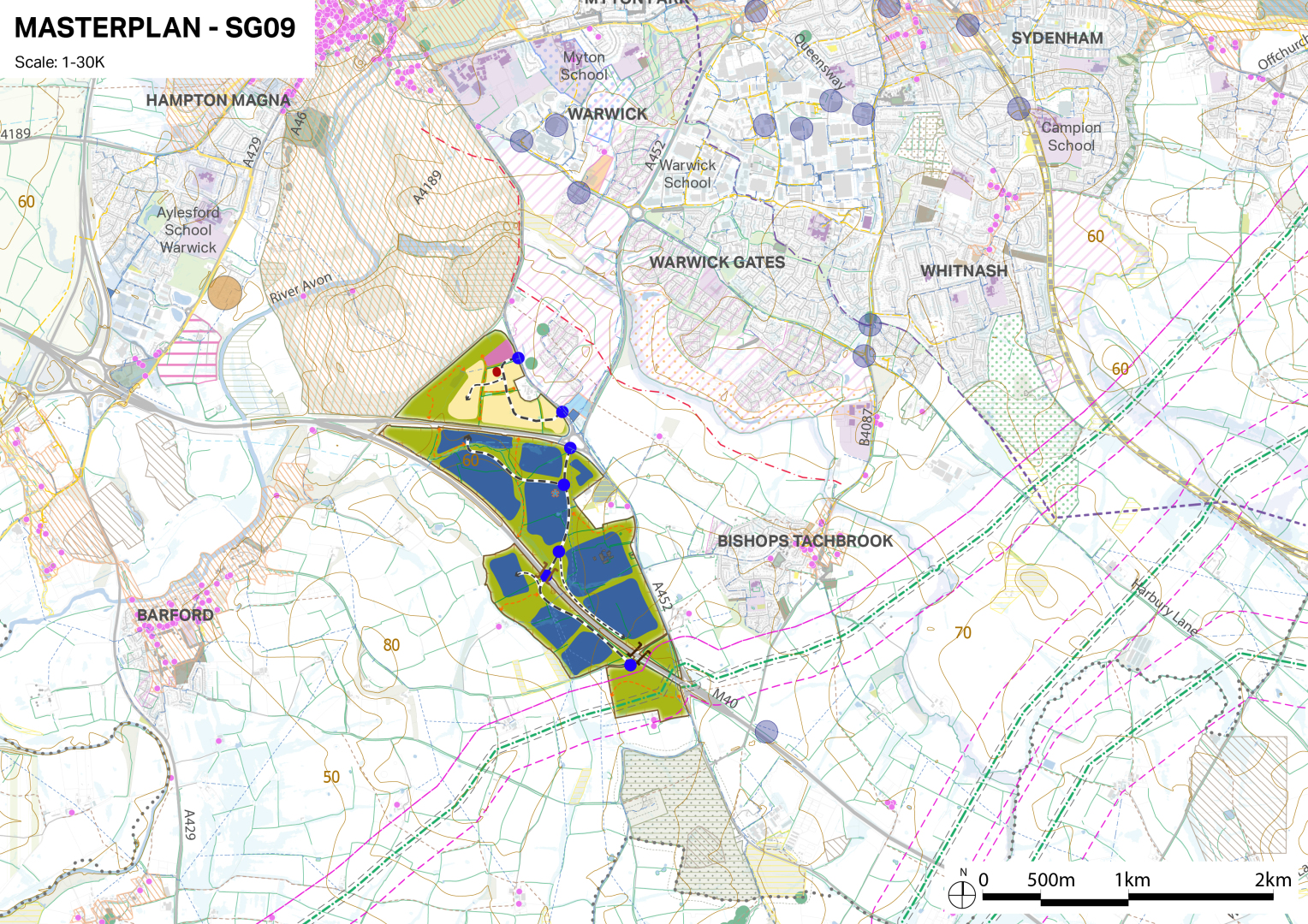
Proposal BIT.2 (Site Proposal) ~ Requirements
Bishop’s Tachbrook – Land to South-west (Red House Farm)
Location
Site BIT.2 is located to the south west of Bishop’s Tachbrook and is bounded by the Warwick Bypass (A452) to the north-west and Banbury Road to the east. The site extends across the M40, with land located on both sides of the motorway.
Site Size
160 hectares overall, with approximately 121 hectares for strategic employment use.
Summary
Land within this allocation will be developed to deliver a gateway strategic employment site with approximately 121 hectares of strategic employment land. Site BIT.2 will deliver a new motorway junction to replace junctions 13 and 14 of the M40, with access to Warwick and Leamington provided via a new dual-carriageway link road through the site. The new junction will include a new bridge across the motorway, providing access to employment areas set within green and blue infrastructure on both the western and eastern sides of the M40.
Timescale
2027-2034/35 .
Key Development and Land Use Requirements
160 hectares of land is allocated for strategic employment development and supporting infrastructure comprising of:
- A gateway development of approximately 121 hectares of strategic employment land comprising 3,750,000 sq ft of employment floorspace.
- Appropriate uses are considered to be those that fall within the logistics and commercial uses (Use Classes B8 and B2).
- A central mixed-use hub providing supporting and ancillary uses including flexible office space; an Innovation Centre; start-up / incubation units; a hotel; a creche; leisure and wellbeing space (for example a gym and sports court); commercial space (for example a café); and a limited amount of key worker housing.
- The delivery of a new motorway junction on the M40 to replace existing junctions 13 and 14 and a new dual-carriageway link road through the site to provide access to Warwick and Leamington Spa, to be funded and delivered by the developer.
- A new Park and Ride facility and multi-modal transport hub with bus and active travel integration and renewable refuelling infrastructure.
- 39 hectares of green and blue infrastructure as part of a comprehensive landscaping scheme.
- Development should contribute to the development of affordable workspace in accordance with Policy EC.4.
- Provision for a travelling showpersons yard suitable to accommodate at least 6 plots, plus amenity space and buildings.
Infrastructure Funding Requirements
- The development will deliver significant new strategic highways infrastructure which will provide wider associated benefits including improved access to other areas of strategic growth and addressing existing issues with the M40 motorway.
- The developers will fund and deliver a new junction on the M40 replacing junctions 13 and 14 which are at capacity. The new junction will provide direct access to Warwick and Leamington Spa via a new dual-carriageway link road through the site to Grays Mallory roundabout and Europa Way.
- Strategic infrastructure, including the motorway junction, main access routes and servicing of employment plots, will be required to be delivered at an early stage in the development, broadly aligned with first occupation.
- The development will include provision of a new Park and Ride facility and multi-modal hub, integrating public transport connectivity with a comprehensive network of active travel routes linking the site to the wider area.
- The development should incorporate supporting infrastructure for sustainable and low carbon transport, including provision for electric vehicle charging and other emerging technologies. The site is expected to be managed by a private management company responsible for the maintenance of communal areas. Strategic road infrastructure will be delivered to adoptable standards and adopted by the relevant Highway Authority.
- Development proposals will be required to contribute to the South of Leamington Sustainable Transport Corridor improving connections to Leamington via Europa Way in accordance with SWLP Policy ID.5.
Urban Design Principles
- Development to be landscape-led, with a strong network of green and blue infrastructure forming the primary framework for the site.
- Development to create a high-quality gateway and sense of arrival to Warwick and Royal Leamington Spa, including strong frontage and design along key routes and the motorway junction corridor.
- Development to incorporate a central hub providing a focal point for activity and supporting uses. Development to be designed sensitively to the surrounding landscape setting, responding to topographical constraints, providing screening to off-site heritage assets, and addressing wider views (including towards the Grade I listed parkland to the north and from the M40), which will be critical to the gateway function.
- Proposals will be expected to demonstrate how they have accounted for the strategic design principles set out in Policy DS.19 (including Design Codes).
Active Travel Requirements
- The development will include provision for a multi-modal hub, integrating public transport through a new Park and Ride facility, with pedestrian and cycle routes.
The development will include provision of a comprehensive network of walking and cycling routes, integrated with public transport infrastructure and the wider movement network with pedestrian and cycle links towards Bishops Tachbrook and Leamington Spa urban areas and allocated housing site BIT.1
https://www.warwickshire.gov.uk/major-transport-construction-projects/a452-europa-way-corridor/2
Access, Highways and Public Transport Requirements
- Development will be required to deliver significant improvements to the local and strategic highway network (as set out above) including integration with the M40 and connections to Greys Mallory roundabout and Europa Way via the new junction and link road. The new M40 junction should include provision for a future access spur in the direction of Wellesbourne.
- Development shall provide a comprehensive network of walking and cycling routes, integrated with public transport infrastructure and the wider movement network.
- Development will be required to deliver a Park and Ride facility and associated bus infrastructure, including provision for enhanced or extended bus services, to support sustainable access to Warwick, Royal Leamington Spa and the wider area. This facility will potentially replace the park and ride at the Asps Park and Ride scheme to the north.
- Development proposals will be expected to demonstrate proactive and collaborative engagement with the relevant highway authorities and statutory bodies to ensure the timely and coordinated delivery of the strategic transport infrastructure necessary for the development.
Environmental Health Requirements
- Development will require a full Environmental Impact Assessment with an appropriate consideration of noise and pollution effects.
Historic Environment Requirements and Constraints
- Development proposals must consider their impact in relation to the nearby heritage assets and must be sensitive to the presence of them and avoid substantial harm.
- An appropriate Heritage Impact Assessment should be prepared to assess potential impacts on heritage and archaeology.
Flood Risk, Drainage and Water Supply
- Site BIT.2 is entirely located in Flood Zone 1 with some areas at risk of surface water flooding.
- All proposals must be prepared in accordance with Policy ID.9 – Reducing Flood Risk and ensure that appropriate measures are in place at sewage treatment works to facilitate the development's progress.
- Appropriate SUDS to deal with surface water drainage should be implemented in accordance with Policy ID.12.
Biodiversity and Green & Blue Infrastructure
- A comprehensive network of green and blue infrastructure will be provided across the site in accordance with Policy ID.13, forming a key structuring element of the development and delivering biodiversity net gain.
- Development will be expected to be designed and delivered in line with the recommendations set out in the SWLP Landscape Assessment and/or the Warwickshire Landscape Guidelines.
- Green infrastructure should be multi-functional, incorporating habitat creation, sustainable drainage, landscape screening and opportunities for access and recreation.
- Development should deliver a strong landscape framework, including woodland planting, green corridors and appropriate buffers to surrounding areas, to mitigate visual impact and integrate the development into the wider landscape.
Public Open Space
- Provision of open space shall be delivered as part of a comprehensive green infrastructure network across the site, comprising a significant proportion of the site and include strategic landscaping, woodland planting and green corridors linking habitats.
- Open space should be multi-functional, incorporating biodiversity enhancement, sustainable drainage, landscape screening and buffering, opportunities for informal recreation and routes for walking and cycling.
- Open space should be integrated with the wider movement network and provide landscape buffers to surrounding areas.
Other Constraints
- Development proposals will be expected to address site-specific constraints, including minerals safeguarding, impacts on the setting of nearby heritage assets, existing utilities infrastructure, on-site watercourses, and the need to provide appropriate buffers to surrounding settlements. Further constraints will be identified through an Environmental Impact Assessment.
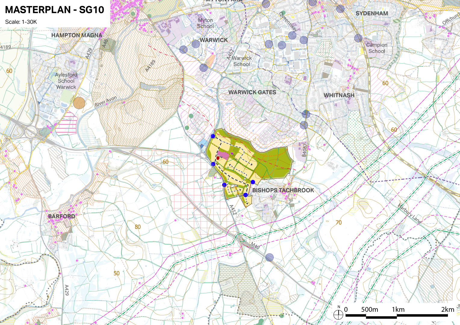
Proposal BIT.3 (Site Proposal) ~ Requirements
Bishop’s Tachbrook – Land to North West
Site Size
122 hectares of land delivering a minimum of 1,720 dwellings across a developable area of approximately 46 hectares, with approximately 74 hectares available for public open space.
Summary
BIT.3: Land to North West of Bishop’s Tachbrook expands existing growth to the south of Warwick and Royal Leamington Spa along Europa Way but focuses development on the existing settlement of Bishop’s Tachbrook, east of Europa Way. It recognises that this is an area of key strategic importance for housing delivery in Warwick District given its location outside of the Green Belt, but that it has also seen a high level of housing growth in recent years. This means that it is vital that opportunities to ensure the delivery of community infrastructure for existing residents is a key part of the vision for the site. This means ensuring overall connectivity with the existing settlement to the south and east, and facilities associated with the Asps development to the north, as well as the other strategic allocations at BIT.1 and BIT.2. Development proposals will be expected to retain effective visual separation between Bishop’s Tachbrook, Royal Leamington Spa, and Warwick through sensitive masterplanning, utilising green buffers and the natural topography, whilst ensuring through connectivity to infrastructure assets via active travel routes. Land within this allocation will deliver a minimum of 1,720 new homes in the plan period. The development will also consist of approximately 74ha of public open space, community facilities, retail and supporting facilities. This includes an approximately 40ha extension to the Tachbrook Country Park to ensure a green lung exists between the north of Bishop’s Tachbrook in perpetuity.
Timescale
From 2028/29 to 2040/41. Opportunities for early delivery are to be considered given the availability of smaller scale sites within the area. Where this occurs, it is vital that the development of these smaller parcels does not preclude the broader delivery of the larger land parcels which are likely to require a greater level of enabling work prior to construction commencing.
Key Development and Land Use Requirements
- Approximately 46ha of land for housing – A minimum of 1,720 dwellings, to be delivered in line with the requirements of the latest SHMA. The housing mix will include an appropriate provision of affordable housing, self-build and custom housing and other unit types to meet local needs.
- A mixed-use community hub with the potential for local retail uses, a village hall, a GP surgery subject to confirmation of the appropriate mix as a response to local needs at the time of a planning application.
- Approximately 2 ha of land for A 2 Form of Entry Primary School
- Approximately 74ha of land for public open space including a range of uses including sport pitches subject to confirmation of requirements from WCC. The development will include a 40ha extension to the Tachbrook Country Park, working in partnership with the parish council to deliver their aspirations for the space. Tachbrook Country Park is identified feature of the Bishop’s Tachbrook Neighbourhood plan and builds on existing proposals contained there.
Infrastructure Funding Requirements
Funding contributions will be required for either the expansion of existing facilities at Oakley School or for a new secondary school to serve the existing settlement alongside Oakley School.
Consideration must also be given to in-combination effects triggering infrastructure requirements alongside other development proposals at Bishop’s Tachbrook, most notably BIT.1 and BIT.2 to the West and South West. Development proposals will also be required to make improvements to accessibility along Europa Way subject to confirmation by the Highways Authority. If the development proposals come forward in advance of BIS.2, it is required to demonstrate that a viable solution is in place regarding impacts on Europa Way, Greys Mallory and the M40.
Development proposals will be required to contribute to the South of Leamington Sustainable Transport Corridor improving connections to Leamington via Europa Way in accordance with SWLP Policy ID.5.
Urban Design Principles
All development shall be delivered through site wide masterplan that is agreed to by all landowners and developers prior to the submission of any planning application. The site area has been defined through a large range of available land in Bishop Tachbrook and is centred on proposals at Land East of Europa Way (HELAA Ref: 698). Additional HELAA Sites included in the site area include:
- Land to South of Mallory Road, Bishop’s Tachbrook (HELAA Ref: 150)
- Land North of Mallory Gardens, Bishop’s Tachbrook (HELAA Ref: 152)
- Land West of Mallory Gardens, Bishop’s Tachbrook, (HELAA Ref: 156)
- Land West of Bishop’s Tachbrook (HELAA Ref 157)
- Land at Solar Farm, Mallory Road, Bishop’s Tachbrook (HELAA Ref: 618)
- Land at New House Farm, Bishop’s Tachbrook (HELAA Ref: 957)
The focus of proposals is to the north of Bishop’s Tachbrook, stretching round its western boundary to Mallory Road. This is with the exception of Land to the South of Mallory Road, as defined by the policies map. Development to the south and east of the existing settlement will not be supported. Development proposals must maintain effective separation between Bishop’s Tachbrook, Royal Leamington Spa and Warwick, utilising the Tachbrook Country Park and localised landscape buffers. these are permeable to enable connectivity between these locations. Consideration is required of the existing varied and undulating site topography, and particularly the role of Windmill Hill. The approach to masterplanning should be landscape led and ensure that key views to and from the development are retained or configured to ensure the retention of rural tranquillity. Proposals will be expected to follow the 20-minute neighbourhood concept where most daily needs can be met within a short active travel trip with car use minimised.
Active Travel Requirements
Active travel will play a key role as part of the vision for integrated green and blue infrastructure. The north west to south east public right of way that connects the A425 to Bishop’s Tachbrook via the Asps must be retained as part of the proposals. In addition, new footpaths and public rights of way will be provided through the country park ensuring connectivity to the Asps Park and Ride and Oakley School for both existing and future residents. This will ensure that residents across Bishop’s Tachbrook parish can enjoy amenities and services at a range of locations, whilst retaining the distinct character of the historic village and new development.
Development proposals will be required to deliver onward connectivity of active travel links beyond BIS.3: Land to North West of Bishop’s Tachbrook towards Warwick and Leamington, working in partnership with the Highways Authority and other providers to deliver connection to key locations in the urban areas to the north.
Access, Highways and Public Transport Requirements
Primary access points would be located on the eastern boundary on the A452 Banbury Road/Europa Way with further options for secondary access on Mallory Road. Consideration is required to ensure that adverse impact on traffic conditions on Europa Way is mitigated. Development proposals must consider their relationship with the existing settlement at Bishop’s Tachbrook and minimise reliance on Mallory Road in access arrangements, ensuring active transport modes a predominantly used by future residents into the settlement. Active transport links to Oakley Wood Road will be supported, provided it can be demonstrated it would not impact upon the operation of the Tachbrook Country Park. This would improve access to Oakley School and reduce the pressure on the surrounding road network. Opportunities are in place for connectivity to a replacement M40 junction as part of the BIS.2: proposals, with through connectivity directly to the A452. Subject to confirmation, options are to be explored regarding network improvements to the A452 and the removal of the western arm of the A452 from the Greys Mallory roundabout. This would allow for through active travel access via dedicated cycleways into the centre of Royal Leamington Spa.
Environmental Health Requirements
Consideration is required of noise impacts and effects on air quality stemming from A452/Europa Way and A452/Banbury Road.
Historic Environment Requirements
Consideration is required of the impacts on the Grade II Listed barn at New House Farm. Access to the heritage asset is via a single-track from Banbury Road that passes through the site. Heritage assessment must be undertaken as part of the development proposals to ensure that appropriate measures are in place to ensure mitigation through design. Secondary consideration of effects on the Bishop’s Tachbrook Conservation Area, including the Grade I Listed St Chard’s Church is also necessary, ensuring mitigation is in place to retain the significance of historic features as required.
Flood Risk, Drainage and Water Supply
Whilst the Site is located predominantly in Flood Zone 1, there are some areas of surface water flood risk which must be considered as part of any masterplan. A scheme of SuDS should ensure that any runoff to the Tach brook is appropriately attenuated so that there are no harmful downstream effects because of the development.
Developments proposals are required to consider the expansion of the Warwick-Longbridge Sewage Treatment works, which may see the construction of a new 250mm diameter foul water main across the site in a north westerly direction from Bishop’s Tachbrook towards Europa Way, crossing into the Asps. Consideration of this will be required as part of development proposals, with Severn Trent Water consulted to confirm the final layout of any future pipeline and any easement requirements.
Biodiversity and Green & Blue Infrastructure
The proposed expansion of Tachbrook Country Park will be a multifunctional Green and Blue infrastructure asset. It will provide a strong green buffer to the northern parts of Bishops Tachbrook ensuring that functional gap is maintained in the landscape south of Royal Leamington Spa. It will deliver a 10% Biodiversity Net Gain, that delivers ecology and habitat diversification to a landscape associated with modern farming. It will ensure that the Tach Brook becomes a natural, biodiverse asset that is. available for public enjoyment. The country park will maintain a distinct visual and physical separation between Heathcote and Bishop’s Tachbrook and provide onward connectivity to other community assets. It will play an important role in reinforcing landscape character and quality. Elsewhere, consideration must be given to the Greys Mallory Local Wildlife Site, ensuring that it is retained and enhanced by proposals, during the construction and operation of the development. Opportunities for Green Infrastructure on the western boundary of Bishop’s Tachbrook to provide effective separation must be explored as part of any detailed site masterplan, responding to site context such as existing landscape features, biodiversity assets, and topography to create a pleasant transition between BIS.3 and the existing settlement of Bishop’s Tachbrook.
Public Open Space
As noted above, the key piece of Public Open Space is the Tachbrook Country Park, which will be delivered between the site promoters and the aspirations of the local community.
Policy BT2 of the Bishop’s Tachbrook Neighbourhood Development plan sets out the following aspirations for the Tachbrook Country Park. The following principles must be important considerations as part of a masterplan:
- Connections to the country park that help to link existing and new residential areas with community facilities, especially schools.
- Outdoor sport and recreation use compatible with the use of the country park.
- Protection of outdoor sport and recreation uses compatible with the use of the areas as a country park.
- Protection of existing and creation of new habitats.
The combined provision of land identified as part of BIT.3 and the NDP is expected to deliver a minimum of approximately 62 hectares of Public Open Space. It is important to ensure that the delivery of the country park occurs in a joined-up manner. Localised areas of public open space will also be supported subject to further consideration of detailed proposals.
8.7 Proposal GAY.1 - Land at Gaydon
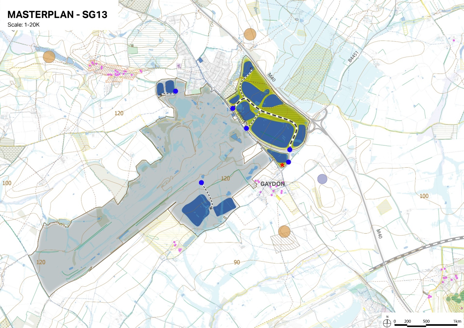
Proposal GAY.1 (Site Proposal) ~ Requirements
Land at Gaydon
Location
The site is situated at and adjacent to the existing Major Investment Site of Jaguar Land Rover (JLR) and Aston Martin Lagonda (AML), south-west of Junction 12 of the M40 at Gaydon.
Site Size
588ha.
Summary
Land within this allocation will be developed to deliver approximately 157 hectares of strategic employment land and 81ha. of non-strategic employment land.
Timescale
Employment development to be delivered within the Plan period.
Key Development and Land Use Requirements
Protect and retain the existing JLR and AML employment sites at Gaydon in accordance with Policy DS.10 Major Investment Sites.
157 hectares of land is allocated for strategic employment development, comprising of:
- 106ha to the north of B4100 and south of M40). Appropriate uses are considered to be those that fall within the E(g), B2 and B8 use classes. However, to retain and protect the site’s strategic focus on supporting economic activities associated with automotive manufacturing:
- At least 50% of the floorspace on the site should be developed for industrial or R&D uses, comprising use classes E(g)(ii), E(g)(iii) and B2;
- Development of B8 floorspace will not exceed 50% of the total employment floorspace on the site.
- Smaller units under 9,300sqm in industrial or office use (Use Class B2, B8 and E(g) (i/ii/iii)) will be permitted but should not form more than 25% of the total floorspace.
- Applications for development should include a marketing strategy targeting automotive manufacturing and engineering, including automotive and associated supply chain and distribution activities.
- Development should ensure appropriate high-quality design and landscaping which responds to the site context. Unit heights should be appropriate to their setting.
- 51ha of land for the expansion of JLR at Land south of JLR, Gaydon Land.Uses permitted will be primarily units in industrial use (Use Class B2 or B8) in strategic size units of 9,300sqm or above. Smaller units under 9,300sqm in industrial or office use (Use Class B2, B8 and E(g) (i/ii/iii)) will be permitted but should not form more than 25% of the total floorspace.
- Development of this site must be for Jaguar Land Rover related automotive research and manufacturing uses only.
81ha of non-strategic employment land, comprising of the following:
- 7.5ha. of land for AML expansion (Use Class B2, B8 and E(g) (i/ii/iii) uses (office/research and development/light industrial) for Aston Martin Lagonda related automotive research and manufacturing uses only.
- 73.5ha of automotive testing tracks at Land west of JLR for the expansion of the existing JLR employment site.
Development should contribute to the development of affordable workspace in accordance with Policy EC.4
- A travelling showpersons yard suitable to accommodate at least 8 plots should be provided, plus amenity space and buildings. This yard will be located in the parcel of land situated between the B4100 and Warwick Road, as shown in the accompanying Masterplan.
Infrastructure Funding Requirements
- Improvements to Harwoods House roundabout
- Three access points to be created from B4100 to 106ha. strategic employment site south of M40/north of B4100)
- Improvements and new slip road to Junction 12 of M40 may be required, subject to delivery of replacement junction to Junction13/14 and the requirements of Local Highways Authority and National Highways
- Active travel links and improvements to existing routes both within site and to nearby settlements.
- Improvements to bus services to Warwick, Banbury, Southam, Wellesbourne, Stratford-upon-Avon and Leamington Spa at key work travel times.
Infrastructure to be delivered as per the Infrastructure Delivery Plan.
Urban Design Principles
- Development to be designed sensitively to the surrounding landscape setting and residential uses
- Development to respect and preserve the setting of the Cotswolds National Landscape and Ancient Woodland.
- Proposals will be expected to demonstrate how they have accounted for the strategic design principles set out in Policy DS.19 (including Design Codes).
Active Travel Requirements
- Contributions will be required to improve active travel connections to Kineton, Warwick and Leamington
- Active travel connections including walking and cycling paths to be provided within the site and to nearby settlements including Gaydon, Kineton and Lighthorne Heath
- Enhance existing Public Rights of Way and LCWIP routes.
Access, Highways and Public Transport Requirements
- Proposals must demonstrate safe vehicular access onto the highway.
- Site should ensure impacts on the operation of B4100 are minimised.
- Possibility for improvements and new slip road to Junction 12 of M40 to be required, subject to delivery of replacement junction to Junction 13/14 and the requirements of Local Highways Authority and National Highways.
- Three access roads to be provided to from the B4100 to106ha. strategic employment site south of M40/north of B4100.
- Improvements to Harwoods House Roundabout.
- Public transport enhancement to bus services to Warwick, Banbury, Southam, Wellesbourne, Stratford-upon-Avon and Leamington Spa at key work travel times.
- Inclusion of bus stop turning circle(s) and bus gates to support bus access and connectivity should be considered.
- Vehicular access to JLR expansion land and JLR testing track expansion) to be provided internally from existing Jaguar Land Rover site.
Environmental Health Requirements
- Mitigation of potential noise pollution to be implemented as recommended by an appropriate Noise Survey.
- Any potential air quality impacts to be addressed and mitigated as recommended by an appropriate Air Quality Survey.
Historic Environment Requirements
- Development proposals must consider their impact in relation to the nearby heritage assets and must be sensitive to the presence of them and avoid substantial harm.
- The findings of the Heritage Impact Assessment should be accorded with.
Flood Risk, Drainage and Water Supply
- All proposals must be prepared in accordance with Policy ID.9 – Reducing Flood Risk so that appropriate measures are in place at sewage treatment works to facilitate the development's progress.
- Appropriate SUDS to deal with surface water drainage should be implemented in accordance with Policy ID.12.
Climate Change
- As per SWLP policies
Biodiversity and Green & Blue Infrastructure
- Development should avoid infringing on the potential LWS and LWS within the site
- A network of green and blue infrastructure should be implemented within the site in accordance with Policy ID.13
- Development will be expected to be designed and delivered in line with the recommendations set out in the SWLP Landscape Assessment and/or the Warwickshire Landscape Guidelines, in particular the following recommendations:
- Ensure any development proposals consider and minimise visual impact on intervisibility from Compton Verney RPG and Conservation Area to the south-west.
- Protect valuable natural features in the landscape, including hedgerows, hedgerow trees, and the woodlands to the north of the B4100, including ancient woodland at Gaydon Coppice.
- Maintain separation between Gaydon and Lighthorne Heath and ensure that any new development around Lighthorne Heath does not result in coalescence of the two distinct settlements.
- Proposals will be required to maintain and enhance, where possible, existing landscape features with biodiversity value, in particular hedgerows and hedgerow trees, identified as ‘key’ landscape features.
- If this is not practicable, to enable the timely and viable delivery of the development, mitigating features should be provided on-site, with a biodiversity net gain delivered in line with national policy and the relevant BNG policies in the SWLP.
Public Open Space
- Public open space to be implemented in accordance with Policy ID.15.
Other Constraints
- Potential Local Wildlife Sites located within existing JLR site and within 100ha proposed employment allocation (site GAY.1) to the north of the B4100.
- Ancient Woodland and LWS located adjacent to site GAY.1
8.8 Proposal HEN.1 - Henley in Arden
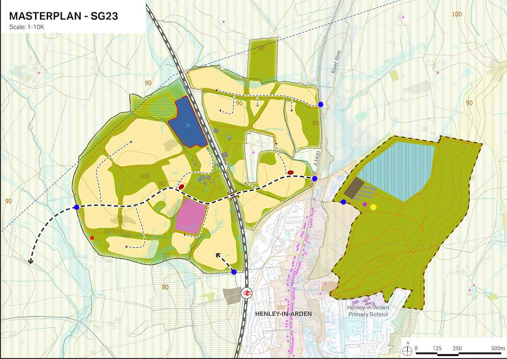
Proposal HEN.1 (Site Proposal) ~ Requirements
Henley-in-Arden
Location
This site is located to the north and west of the existing settlement of Henley-in-Arden, primarily utilising land at the current Henley-in-Arden Golf Club. A new Country Park is also proposed as part of the Masterplanned site at Beaudesert Mount, to the north-east of the town.
Site Size
125.3ha (excluding land proposed for new Country Park at Beaudesert Mount)
Summary
Land within this allocation will be developed to deliver a comprehensively masterplanned development of a minimum of 2,084homes, 3.3 hectares of employment land (research, development and office uses). In addition, land within this allocation will be used for community and leisure uses including a two-form entry primary school, medical centre, allotments, sports and leisure, Public Open Space and new country park at Beaudesert Country Park.
A new link road to connect the site through from the A3400 Birmingham Road to the A4189 Henley Road will be provided, incorporating a vehicular rail bridge over the railway line. Improved pedestrian access and cycling routes will be provided to the town centre and Henley Railway Station.
Timescale
2029/30 - 2044/45
Key Development and Land Use Requirements
Residential
- A minimum of 2,084 dwellings, to be provided within four phases (earliest phases to be provided closest to the existing settlement)
- Provision of dwellings must accord with housing mix and affordable housing policies.
- 9 pitches for Gypsies and Travellers, to be located in accordance with the accompanying Masterplan
Employment
- 3.3ha. of employment provision a part of an innovation hub for research, development and office uses (Use Class E(g)(i and ii).
Education
- 2FE primary school to be provided on-site, with the potential for expansion to 3FE to accommodate population growth
- Expansion of existing secondary school and provision of sixth-form at Henley-in-Arden School
Community
- Allotments to be provided on-site
- Sports pitches and play areas
- Care home
- Local shops
- Town square
- Health and community centre
- Neighbourhood centre
- Country park with a network of walking and cycling routes, visitor centre and visitor parking facilities.
Infrastructure Funding Requirements
Transport
- Link road connecting the site from north-east to south-west to enable traffic travelling from/to Redditch direction to bypass Henley-in-Arden town centre.
- Improvements to Henley rail station
- Proposed new bridge over railway line to be provided through BAPA with Network Rail
- Junction upgrades to A3400, A4189, Mays Hill and Ullenhall Road.
- Active travel improvements from site to town centre and the train station.
Education
- Contributions will be required to ensure the expansion of the existing Henley-in-Arden School and provision of a new sixth form centre.
- A 2FE primary school will be provided on-site, with the potential to expand to 3FE for future pupil demand from population growth.
Green Infrastructure, Public Open Space and Flood Alleviation
- Flood alleviation works including SuDS, attenuation basin and potential for related flood alleviation infrastructure
- River corridor restoration and buffer zones
- Green and blue infrastructure and open space to be provided throughout site
- Allotments and community growing areas to be provided on-site
- Play areas and sports pitches to be provided
- New Country Park with network of walking and cycling facilities and visitor centre
Health care and Community
- Community centre to be provided on-site within reopened golf clubhouse
- Primary contribution to be made or on-site health hub to be provided
- Care home to be provided on-site
- Local shops to be provided within neighbourhood centre
- Contributions to be made towards leisure facilities
Urban Design Principles
- Development will include a strong landscape buffer to provide a defensible Green Belt boundary
- The proposed Country Park will be linked to the wider site with a network of walking infrastructure
- Proposals will be expected to demonstrate how they have accounted for the strategic design principles set out in Policy DS.19 (including Design Codes).
- Active frontages to be provided to neighbourhood centre and town square
- Public open space and green infrastructure to be integrated throughout the site, ensuring accessibility for all residents
- Pedestrian and cycle access to the town centre and train station as well as throughout the site should be prioritised in the design.
- Proposals will be expected to follow the 20-minute neighbourhood concept where most daily needs can be met within a short active travel trip with car use minimised.
- Development must conserve and enhance the designated heritage assets within and near to the site, including the Grade II Listed Buildings of Crockets Farmhouse, Beaudesert Park the Scheduled Ancient Monument of Beaudesert Castle and the Henley-in-Arden Conservation Area.
- A buffer between the south-eastern boundary and the Henley-In-Arden Conservation Area to preserve views from the historic high street.
- Community uses should be provided in a central location and accessible both by residents of the site and to the wider town of Henley-in-Arden.
Active Travel Requirements
- Pedestrian/cycle connectivity improvements from and within the site, in particular to the Henley-in-Arden Railway Station and the town centre
- Walking and cycle routes to be integrated throughout the site
- New network of footpaths, woodland and meadow trails and improved paths to be provided within the new Beaudesert Country Park, including new circular walking path.
Access, Highways and Public Transport Requirements
- New accesses to be provided to the south (Train station), east (Birmingham Road) and west (Link Road connecting to Henley Road) of site.
- New junction to be provided to A3400 Birmingham Road.
- Link road through the site connecting the A3400 Birmingham Road to Henley Road A4189 to be provided. Potential for T-junction or roundabout at the western site boundary, dependent on supporting transport assessment.
- Works to improve A4189/Henley Road junction.
- Potential for right-turn lane or roundabout at Mays Hill, dependent on transport evidence.
- Traffic calming measures to be implemented to Henley High Street (A3400)
- New vehicular railway bridge to be provided
- Enhanced bus services
- Enhanced rail services between Birmingham and Stratford-upon-Avon
- Potential improvements required to the following highways infrastructure, dependent on outcomes of detailed transport assessment:
- Mayswood Road;
- Stratford Road/Warwick Road crossroads;
- Henley Road/Birmingham Road A435 ‘Dog’ roundabout; and
- Bishopton Roundabout.
Environmental Health Requirements
- Any noise and air quality impacts from proposed new highway infrastructure should be assessed and appropriately mitigated.
- Development should be set back from Birmingham Road and the rail-line and screened with appropriate landscaping to reduce potential noise impacts.
Historic Environment Requirements
- Designated heritage assets affected by the proposed development must be conserved and enhanced.
- Development must respect the setting of the Scheduled Ancient Monument at Beaudesert Mount.
- An appropriate buffer to the designated heritage assets must be incorporated within the proposed development, including a landscape buffer between the boundary of site and the Conservation Area.
Flood Risk, Drainage and Water Supply
- A flood alleviation scheme comprising of an attenuation basin and associated infrastructure will be created to the north of the proposed Country Park for the wider benefit of Henley-in-Arden.
- A network of sustainable drainage features (SuDS) including swales and above ground detention ponds should dispose of storm water in line with the Drainage Feasibility Report. SuDS will be designed to maximise biodiversity and leisure benefits.
- Foul water will drain to new pumping stations before discharging to the existing Severn Trent network.
Climate Change
- All homes will be required to engage in sustainable design and construction, including the use of renewable and low-carbon energy, in accordance with Policies NZ.1 - Operational Net Zero in New Residential Buildings, NZ.3 Embodied Carbon and NZ.5 Climate Resilient Design.
Biodiversity and Green & Blue Infrastructure
- Development to include strong landscape buffer at the site boundaries to provide defensible Green Belt boundary and sensitive transition to the countryside
- Proposals will be required to maintain and enhance, where possible, existing landscape features with biodiversity value, in particular hedgerows and hedgerow trees, identified as ‘key’ landscape features.
- Development to be set back from the rail-line to provide a green corridor buffer and provide landscape screening for the secondary school and nearby development parcels
- If this is not practicable, to enable the timely and viable delivery of the development, mitigating features should be provided on-site, with a biodiversity net gain delivered in line with national policy and the relevant BNG policies laid out elsewhere in the SWLP.
- Existing green corridors within the former Golf Course should be enhanced to retain green infrastructure.
- Local Wildlife Sites should be retained within the site.
- The Environment Agency will be consulted with to identify suitable habitats within the proposed flood alleviation area on The Mount land.
Public Open Space
- New country park to be created to the east of the site within the setting of and including the Beaudesert Mount Scheduled Ancient Monument, including walking trails and improved paths, with associated visitor centre and parking facilities.
- Public open space to be integrated throughout the site, including play and sports and leisure areas.
Other Constraints
- Site to be released from Green Belt, excluding proposed link road, Country Park and flood attenuation scheme.
- The north-western edge of the site contains high voltage power lines. This must be kept free from development and retained as open space
- A 16m easement corridor relating to two Severn Trent potable water mains must be kept free from built development
8.9 Proposal KEN.1 - Kenilworth - Land to the south
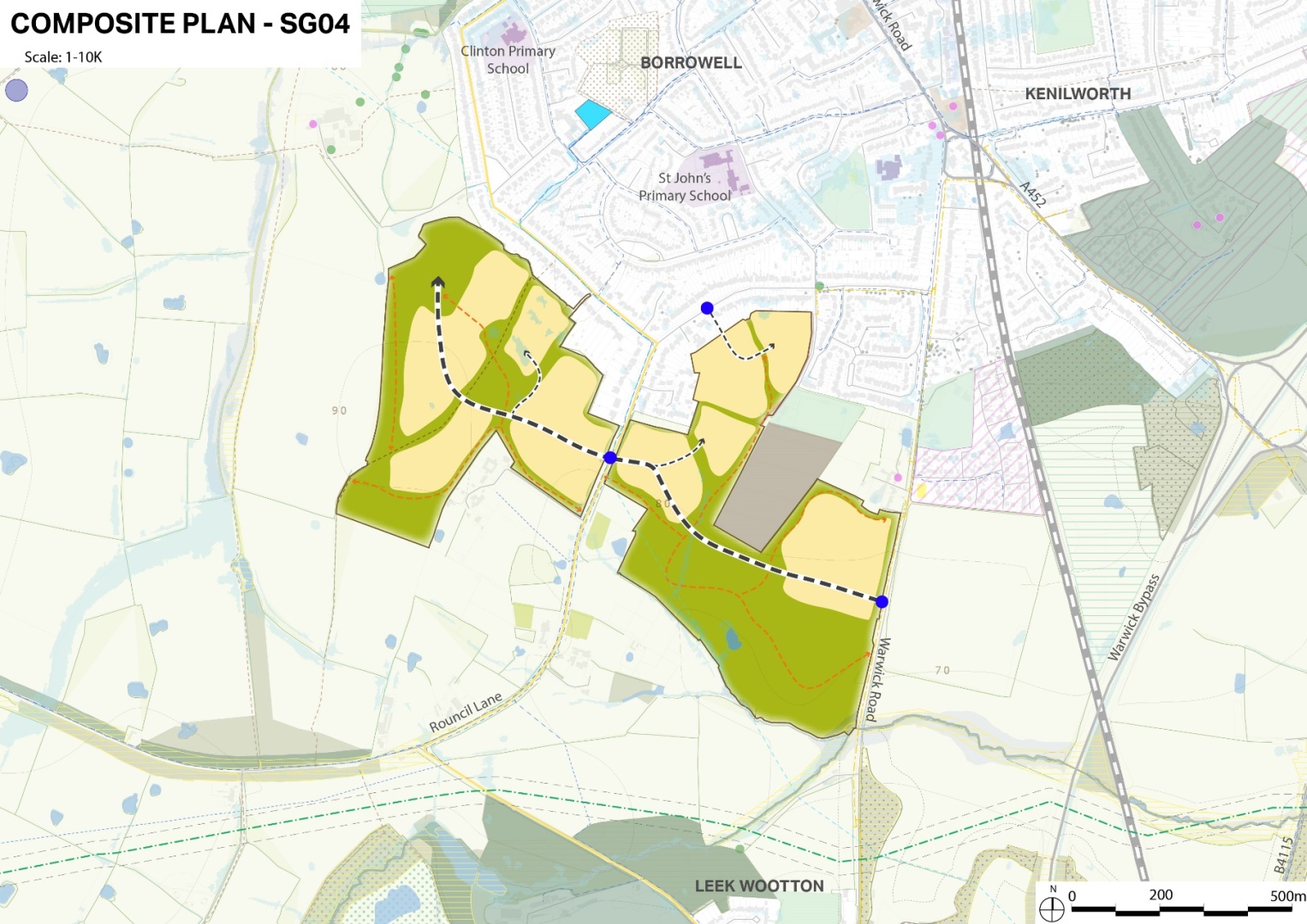
Proposal KEN.1 (Site Proposal)
Land south of Kenilworth
Site Size
60 ha
Summary
Land within this allocation will be developed to deliver a minimum of 776 new homes and public open space.
Timescale
From 2029/30 to 2036/37
Key Development and Land Use Requirements
- Approximately 776 dwellings at a density of at least 35dph and in keeping with the adjacent settlement character.
- Affordable housing provision in accordance with Policy DS.4
- Public open space incorporating play facilities and SuDS
- Significant green edge within the allocation boundary to maintain separation between southern Kenilworth and Leek Wootton.
Infrastructure Funding Requirements
- Funding contributions towards off-site primary, secondary and specialist education facilities, health services.
- Active travel provision.
- Contributions to support and expand the Demand Responsive Transport ‘IndieGo’ service
- Contributions to mitigate any adverse highways impacts identified.
- Development proposals will be required to contribute to the South of Coventry Sustainable Transport Corridor improving connections to Coventry and Royal Leamington Spa in accordance with SWLP Policy ID.5.
Urban Design Principles
- Compliance with Masterplan
- Proposals will be expected to follow the 20-minute neighbourhood concept where most daily needs can be met within a short active travel trip with car use minimised.
Active Travel Requirements
- Link into the National Cycle Network Route 52 on Rouncil Lane and Rounds Hill via connecting routes and signage.
- Encourage active travel connections between adjoining land parcels and through existing residential areas of south Kenilworth.
- Active travel plan.
Access, Highways and Public Transport Requirements
- Land East and West of Rouncil Lane – access to be taken from Rouncil Lane, via a single roundabout to serve both development parcels.
- Land West of Rouncil Lane - a second access into the site will be necessary to deliver greater than 150 dwellings on this land parcel.
- Land West of Warwick Road – access to be taken from Warwick Road.
- A spine road through the site, connecting Rouncil Lane and Warwick Road will be necessary to provide an east-west connection and to avoid unacceptable impacts on other local routes. This should be completed in the earliest possible phase of the development.
- Ex Kenilworth Sixth Form site – access to be taken via existing access road off Rouncil Lane.
- Improvements to both Rouncil Lane and Warwick Road to create footways to allow for safe pedestrian movements both to/from Kenilworth, including appropriate crossing points.
- Provision of additional bus stops on Warwick Road to serve land West of Warwick Road.
Historic Environment Requirements
- Incorporate a buffer to the north-west of the site to minimise any impact on sightlines from Kenilworth Castle.
- Development in this area should respect the scale and mass of present settlements and buildings. The use of traditional materials in keeping with the present buildings of villages such as Leek Wootton is advocated.
- Traditional boundary treatments such as hedgerows should be maintained or created, particularly on the southern boundary, in order to maintain a separation with the village of Leek Wootton.
Flood Risk, Drainage
- Develop a surface water drainage strategy which adequately deals with any additional surface water run off generated by the development.
- Incorporate SuDs and balancing ponds in the open space to the within the southern part of the allocation as required.
- An assessment of sewerage capacity will be required in consultation with Severn Trent Water. If required, there may be a need to facilitate upgrades to sewage treatment capacity at Finham Waste Water Treatment works.
Biodiversity and Green & Blue Infrastructure
- Proposals should make provision for a belt of public open space towards the southern boundary of the allocation to both provide a strong, defensible Green Belt boundary to the south of Kenilworth, maintaining separation between the settlements of Kenilworth and Leek Wootton
- Retention of existing hedgerows and notable trees.
- Incorporation of existing Public Rights of Way through the site, maintaining accessibility to the wider countryside.
Public Open Space
Provision in line with Policy ID.14: Open Space, Play, Recreation and Community Growing Spaces, ensuring:
- Local Equipped Areas for Play should be included across the allocation, responding to local needs and ensuring that all age ranges and specialist needs are catered for.
- Contributions to outdoor sports provision in line with identified needs in the Kenilworth sub-area (SA1) in 2025 Playing Pitch Strategy.
- Provision of allotments to the expand upon the existing St John’s allotments.
Other Constraints
The Site falls within a Mineral Safeguarding Area for unconsolidated sand and gravel, as identified in the adopted Warwickshire Minerals Local Plan 2018-2032 (July 2022). Regard must therefore be had to policies MCS 5: Safeguarding Minerals and Minerals Infrastructure and DM 10 Mineral Safeguarding.
To ensure the satisfactory amenity of new homes, any application may need to be accompanied by an odour assessment as necessary. Applicants should liaise with Environmental Health Service in this regard.
8.10 Proposal LEA.1 - Leamington Spa - Land to North (Blackdown)
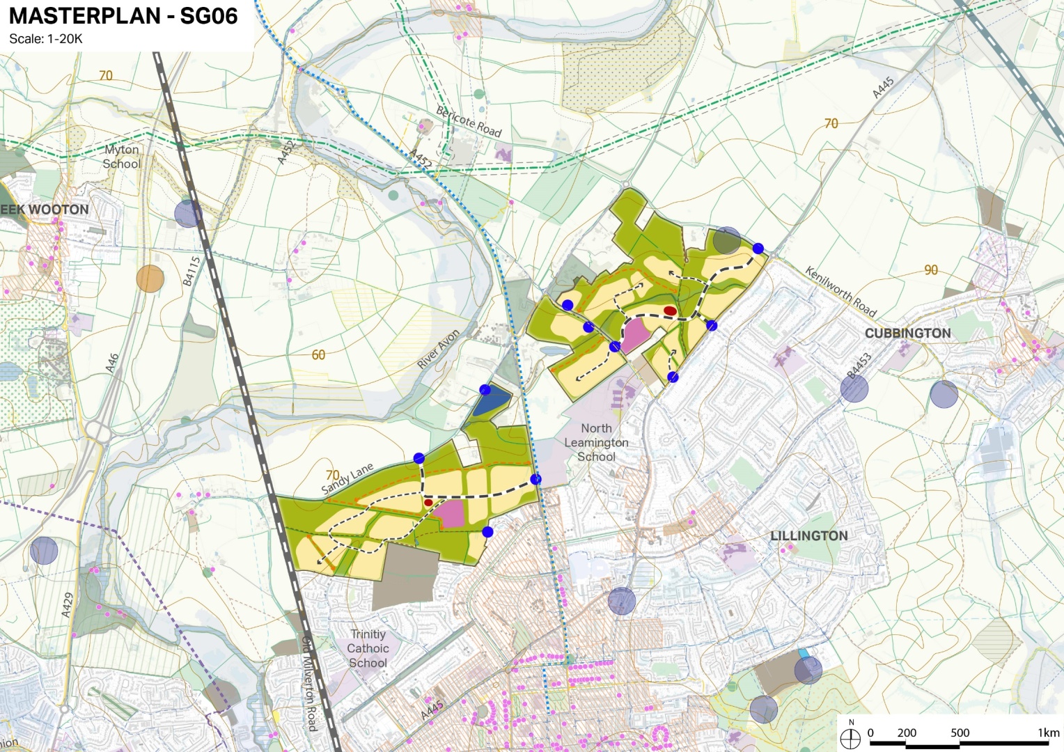
Proposal LEA.1 (Site Proposal) ~ Requirements
Land North of Leamington Spa (Blackdown)
Site Size
72 hectares to be released from the Green Belt comprising of:
- A minimum of 1,043 dwellings to be delivered across approximately 37 hectares with additional supporting infrastructure.
- Approximately 35 hectares of public open space, including areas of play, biodiversity, and public rights of way.
Summary
Land at North of Leamington Spa (Blackdown) forms part of a series of sustainable urban extensions to the north of Royal Leamington Spa, with further supporting land parcels to enable the rapid delivery of housing. The planned growth will be genuinely sustainable, supporting the existing community through providing additional pieces of key infrastructure. Consideration will be given throughout the delivery of the development to its relationship with its neighbouring site, LEA.2 Land North of Leamington Spa (Milverton).
Land at North of Leamington Spa (Blackdown) is available for a minimum of 1,043 dwellings across 3 separate land parcels. This is predominantly through the primary Land at Blackdown site (HELAA Ref:174) with additional options available at Field at Leicester Land (HELAA Ref: 602) and Land North of Sandy Lane (HELAA Ref: 708).
Timescale
Anticipated to be delivered in the period 2031/32-2041/42. Opportunities for early delivery are to be considered given the availability of smaller scale sites within both areas. Where this occurs, it is vital that the development of these smaller parcels does not preclude the broader delivery of the larger land parcels which are likely to require a greater level of enabling work prior to construction commencing.
Key Development and Land Use Requirements
- Housing – a minimum of 1,043 dwellings in the period to 2050, including affordable housing provision in accordance with Policy DS.4
- Community & Leisure – a community hub/local centre.
- Education – on-site provision of a 2FE Primary School across approximately 2ha of land.
- Public Open-Space – Approximately 35ha with extensive open space, including sport pitches, allotments, community orchard and play areas.
- Land to be safeguarded for the expansion of North Leamington School if required.
Infrastructure Funding Requirements
Infrastructure will be provided through a Section 106 agreement or the Community Infrastructure Levy (CIL) depending on the type of contribution sought.
A key consideration for development to the north of Royal Leamington Spa is ensuring that there is sufficient secondary education capacity at North Leamington School, or via a new provision.
The Site falls within the area of search for a Park and Ride to the north of the town. This means that land may need to be safeguarded as part for a North Leamington Park and Ride scheme; however, this is subject to consideration as part of an overall site wide masterplan and an assessment of local need. Given the proximity between Land at Blackdown and Land North of Leamington Spa, it is expected that a joint approach to funding is taken by site promoters to key pieces of identified infrastructure, such as the Park and Ride.
Development proposals will be required to support funding arrangements for improvements to the A452 corridor between Royal Leamington Spa and Kenilworth in the line with the IDP and any future supplementary work carried out by the Local Planning Authority. Development proposals will be required to contribute to the South of Coventry Sustainable Transport Corridor improving connections to Coventry and Royal Leamington Spa in accordance with SWLP Policy ID.5.
Where off-site impacts are identified, proposals will also be required to consider their effect alongside East of Lillington, given their proximity to one another.
Urban Design Principles
Development must be subject to a site wide masterplan that considers the overarching vision, layout and land uses for development proposals alongside likely cumulative effects that will arise with Land at North of Leamington. However, it is also accepted that local variance in design terms will reflect the local context and aspirations of developers and site promoters.
Land North of Blackdown will provide a sustainable location for new housing on the northern edge of Royal Leamington Spa. To ensure that development proposals limit landscape harm, residential land uses must respond to existing field patterns, and site topography.
A community hub must be centrally located within the site providing local convenience retail uses. Opportunities should be considered to allow for the expansion of North Leamington School, with implications for the wider layout and provisions of open space within the layout, ensuring permeability and accessibility for all users. Proposals will be expected to follow the 20-minute neighbourhood concept where most daily needs can be met within a short active travel trip with car use minimised.
Active Travel Requirements
Existing public right of ways (PRoWs) must be retained throughout the site. Development proposals must ensure their continued use and tranquillity.
Both LEA.1 Land at North of Leamington Spa (Blackdown)and LEA.2 Land North of Leamington Spa (Milverton) are expected to provide onward connectivity for active travel modes into the surrounding road network and ensure that sufficient measures are in place to provide requisite safety for future users, enabling residents to engage in active lifestyles.
Both LEA.1 and LEA.2 sites are also expected to contribute towards the emerging Kenilworth to Leamington (K2L) cycle route and the Offchurch Greenway. It is vital that there is direct connectivity between the site and the K2L route along Kenilworth Road. Development proposal will be required to demonstrate permeability to LEA.2, and to the wider settlement of Royal Leamington Spa to the south.
Access, Highways and Public Transport Requirements
If required following transport hierarchy prioritisation, both LEA.1 and LEA.2 sites will be expected to contribute towards upgrades to the STA Scheme 2 – A452/Stoneleigh Road/Blackdown Roundabout, STA Scheme 5 – Bericote Road/Stoneleigh Road Roundabout and STA Scheme 6 - Westhill Road/Leicester Lane Roundabout, which will require signalisation and widening as applicable. Development proposals will be expected to consider their impact on Kenilworth Road/A452 corridor, in particular on the A452 South between Bericote Island and Lillington Avenue. They will also be required to consider impacts on the surrounding road network, making any further improvements identified in the Strategic Transport Assessment in the north of Royal Leamington Spa.
Specifically, proposals at Land North of Leamington Spa Blackdown will be required to demonstrate safe access, from Sandy Lane and Leicester Lane. The development will consist of several access points across Sandy Lane & A445 Leicester Lane, with new priority and roundabout junctions, connected with a link road through the site. Direct access onto Sandy Lane is restricted to the parcels of land to the west of Sandy Lane where there is no practical alternative. Access to the parcels of land to the east of Sandy Lane to be limited to Leicester Lane and Westhill Road – with the main access being proposed opposite Telford Avenue. It is vital that access too Sandy Lane is safe, with reductions in speed limits as required by the Highways Authority.
Development proposals will be expected to ensure permeability over the A445 near to North Leamington School, ensuring that there is enhanced walking connection between the development parcels and nearby communities. The 67 Bus service will be enhanced as part of proposals and extended into the Site subject to confirmation of feasibility from the relevant operator.
Historic Environment Requirements
Land North of Leamington Spa (Blackdown) is required to consider its role in terms of their relationship with the setting of the Royal Leamington Spa Conservation Area. In particular, noting the role that Kenilworth Road plays in approaching the town from the north.
Flood Risk, Drainage and Water Supply
The vast majority of the site is located within Flood Zone 1, with some minor areas located within Flood Zone 2 and 3 associated with an unnamed watercourse that runs through them. Development proposals will be required to ensure that the developable area is directed towards the most suitable locations, avoiding areas of risk and using SuDS to ensure that overall downstream effects are reduced as a result of the development.
Some areas of surface water flood risk are located within both sites. Likewise, these must be dealt with holistically through appropriate master planning, using attenuation basins to ensure appropriate, controlled discharge.
Biodiversity and Green & Blue Infrastructure
Development proposals are required to provide a 10% Biodiversity Net Gain in line with national guidance; the following site-specific principles apply to each of the proposed development locations:
Land North of Leamington Spa (Blackdown) consists of arable land with hedgerows and trees contained through the existing field pattern. The proposed development will be expected to retain these existing field boundaries to create a multi-functional network of green corridors that enable movement through the site.
Areas of open space will contain biodiversity, as well as SuDS to ensure the watercourse through the site is maintained and enhanced, noting its role as a tributary of the River Avon. Development proposals must consider areas of Best and Most Versatile Agricultural Land, which must be utilised to provide areas of planting and community assets such as orchards or allotments in amenable locations.
Strong planting will be required on the boundaries of the site to ensure that the landscape character towards Green Belt is retained. Community gardens and allotments will be provided through the site with through access to Stoneleigh Road and Sandy Lane acting as a focal point for public open space, in line with their more rural settings.
The retained public right of way between Leicester Lane and Westhill Road will act as the primary green corridor and primary active travel route enabling connectivity from the site to the surrounding area, including to the new strategic cycle network focused on Kenilworth Road.
As the site falls within the setting of the Dunsmore Living Landscape, developers will be required to work positively with Warwickshire Wildlife Trust providing contributions as sought.
Public Open Space
It is expected that 35 hectares of public open space will be provided. This should be delivered through a range of different formal and informal uses including areas of play, allotments, community orchards, meadows, and sports pitches.
Particular care will be taken to preserve as far as possible the amenity of existing residents living either within or adjacent to the Site through the appropriate use of public open space.
8.11 Proposal LEA.2 - Leamington Spa - Land to North (Milverton)
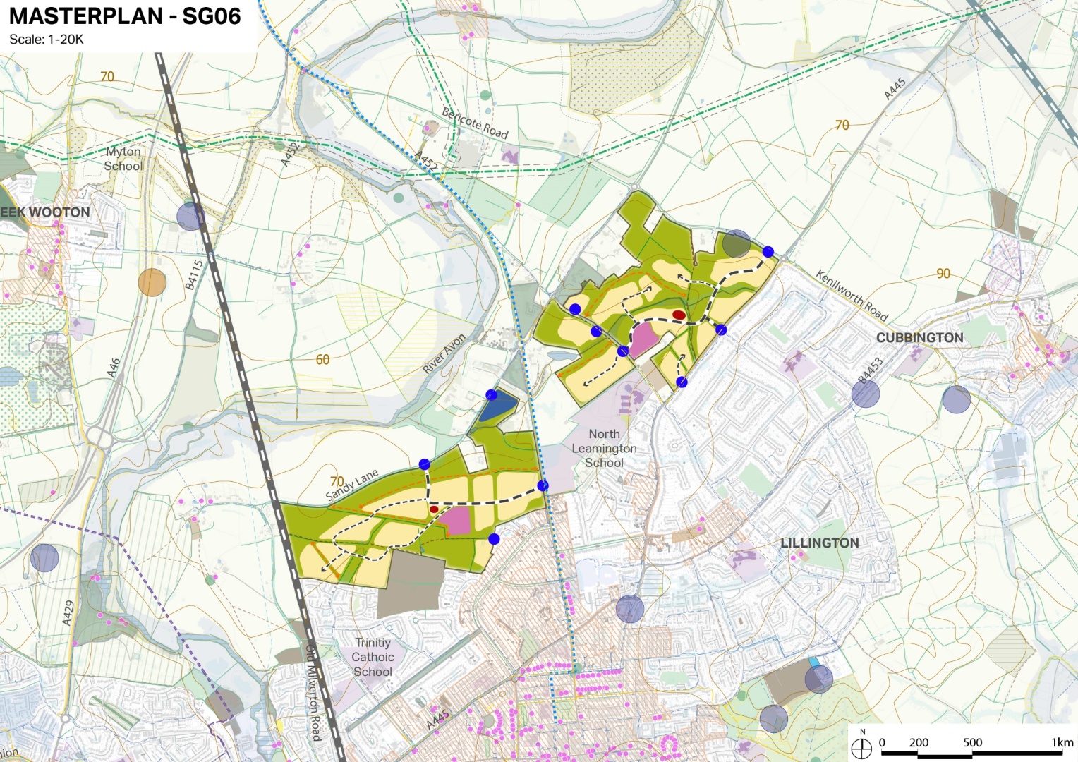
Proposal LEA.2 (Site Proposal) ~ Requirements
Land North of Leamington Spa (Milverton)
Site Size
76 hectares to be released from the Green Belt comprising of:
- A minimum of 974 dwellings to be delivered across approximately 38 hectares with additional supporting infrastructure.
- Approximately 38 hectares of public open space, including areas of play, biodiversity, and public rights of way.
Summary
Land North of Leamington Spa (Milverton) is the second of two sustainable urban extensions to the north of Royal Leamington Spa.
Proposals will consider their sensitive location having been released from the Green Belt between Kenilworth and Royal Leamington Spa. As such, a landscape led approach to the sites is vital when developing detailed proposals.
Land North of Leamington Spa (Milverton) is available for a minimum of 974 dwellings, across two land parcels. This is predominantly through the primary Land North of Leamington Spa site (HELAA Ref:531) with opportunities for additional delivery at Land Off Bamburgh Grove (HELAA Ref: 165).
Timescale
Anticipated to be delivered in the period 2032-2045. Opportunities for early delivery are to be considered given the availability of smaller scale sites within both areas. Where this occurs, it is vital that the development of these smaller parcels does not preclude the broader delivery of the larger land parcels which are likely to require a greater level of enabling work prior to construction commencing.
Key Development and Land Use Requirements
- Housing – a minimum of 974 dwellings in the period to 2050, including affordable housing provision in accordance with Policy DS.4 Employment – provision of approximately 2ha of non-strategic employment land subject to local needs.
- Retail – 1ha for provision of a food store providing up to15,000 sq.ft of floor space.
- Community & leisure – provision of approximately 0.35ha for a mixed-use local centre with a range of potential uses as required by NHS Coventry and Warwickshire ICB and other providers.
- Healthcare and Employment – approximately 2ha for a potential hospital expansion or alternative employment land.
- Education –approximately 2.35ha for on-site provision of a 2FE Primary School.
- Public Open Space – A minimum of 38ha of multifunctional green infrastructure, incorporating structured landscaping, formal/informal open space, sports pitches, play facilities, community orchard and SuDs.
Infrastructure Funding Requirements
Infrastructure will be provided through a Section 106 agreement or the Community Infrastructure Levy (CIL) depending on the type of contribution sought.
Land North of Leamington (Milverton) will be required to ensure that there is sufficient secondary capacity at the North Leamington School or an alternative secondary education solution in place to support the development.
In addition, land may be provided as for a hospital expansion, or local employment uses subject to confirmation of what is appropriate by the relevant infrastructure providers.
Land North of Leamington (Milverton) is near the area of search for a Park and Ride to the north of Royal Leamington Spa, with options to bring the scheme at the Blackdown and Bericote roundabouts as part of LEA.1 Land North of Leamington Spa (Blackdown). Given the proximity between both sites, it is expected that a joint approach to funding is taken by site promoters to key pieces of identified infrastructure such as a future Park and Ride.
Development proposals will be required to support funding arrangements for improvements to the A452 corridor between Royal Leamington Spa and Kenilworth in the line with the IDP and any future supplementary work carried out by the Local Planning Authority. Development proposals will be required to contribute to the South of Coventry Sustainable Transport Corridor improving connections to Coventry and Royal Leamington Spa in accordance with SWLP Policy ID.5.
Development proposals must also consider cumulative effects alongside LEA.3 Land East of Leamington Spa (Lillington).
Urban Design Principles
All development must be subject to a site wide masterplan that considers the overarching vision, layout and land uses, it is also accepted that local variance in design terms may reflect the local context and aspirations of developers and site promoters. Proposals must consider their relationship with Land North of Leamington Spa (Blackdown). In this context design codes will be required to specific site-specific context.
Land North of Leamington (Milverton) is located on the northern edge of the existing settlement, with sensitive views from the existing settlement and surrounding countryside. This means that it is vital that consideration is given to the local context ensuring that any masterplan and subsequent layout is landscape led. Consideration should be given to areas of sensitivity, especially to the frontage on Kenilworth Road and Sandy Lane, with areas of open space provided at areas of identified sensitivity.
Likewise, the rolling topography means that there are areas of higher ground with greater visibility from the existing settlement. Consideration should also be made as to how these can be utilised effectively to ensure the character of the landscape is retained. Development proposals must consider areas of Best and Most Versatile Agricultural Land, ensuring that where this falls in the developable area, it is utilised to provide areas of planting and community assets such as orchards or allotments.
Proposals must incorporate a range of residential properties with a mix of house types that reflect market choices, with a wide-ranging area of Public Open Space. Other uses should be provided in keeping with the masterplan to ensure that development meets the needs of existing, as well as future residents. Proposals will be expected to follow the 20-minute neighbourhood concept where most daily needs can be met within a short active travel trip with car use minimised.
Active Travel Requirements
Existing public right of ways (PRoWs) must be retained throughout the Site. At LEA.2 Land North of Leamington (Milverton), the public footpath that enters the site from Guys Cliffe Avenue, and the south western boundary should be retained, as well as other minor PRoWs. Development proposals must ensure their continued use and tranquillity.
Development proposals are expected to provide onward connectivity for active travel modes into the surrounding road network and ensure that sufficient measures are in place to provide requisite safety for future users, enabling residents to engage in active lifestyles.
Development proposals are expected to contribute towards the emerging Kenilworth to Leamington (K2L) cycle route and the Offchurch Greenway. Development proposals will be required to demonstrate safe access to K2L, in order to enable active travel to and from the site via traffic light controls. Onward connectivity should also be ensured from the south, via Guys Cliffe Avenue.
Access, Highways and Public Transport Requirements
If required following transport hierarchy prioritisation, both LEA.1 (Blackdown), and LEA.2 (Milverton) will be expected to contribute towards upgrades to the STA Scheme 2 – A452/Stoneleigh Road/Blackdown Roundabout, STA Scheme 5 – Bericotre Road/Stoneleigh Road Roundabout and STA Scheme 6 - Westhill Road/Leicester Lane Roundabout, which will require signalisation and widening as applicable.
Development proposals will be expected to consider their impact on Kenilworth Road/A452 corridor, on the A452 South between Bericote Island and Lillington Avenue. They will also be required to consider impacts on the surrounding road network, making any further improvements identified in the Strategic Transport Assessment in the north of Royal Leamington Spa.
Development proposals must ensure safe access to Kenilworth Road for road users and active travel users, ensuring the safe operation and access to the K2L cycle route. This also means ensuring that there is appropriate pedestrian access crossing the A452, facilitated by traffic light-controlled junctions. The Old Milverton/Rugby Road junction must also be upgraded to take account of the extra local traffic that will be generated.
Opportunities are to be explored to provide the Sandy Lane bus gate to improve sustainable transport provision.
Two access points are to be provided via junctions at Kenilworth Road & Sandy Lane, with a link road through the site providing internal connectivity. Potential third access from Guy Cliffe Avenue subject to phasing and delivery of primary school.
It is vital that there is appropriate consideration of in-combination effects with the proposed supermarket on site access once trip demand increases for this amenity. This is particularly important given the identified lack of retail offer in the north of Royal Leamington Spa currently.
Historic Environment Requirements
Development proposals are required to consider their role in terms of their relationship with the setting of the Royal Leamington Spa Conservation Area. In particular, noting the role that Kenilworth Road plays in approaching the town from the north.
Development proposals must consider its impact on several designated heritage assets in its context, namely the Listed Buildings of Old Milverton, and Guy’s Cliffe Registered Park and Garden.
Flood Risk, Drainage and Water Supply
The site is located within Flood Zone 1, with some minor areas located within Flood Zone 2 and 3 associated with an unnamed watercourse that runs through them. Development proposals will be required to ensure that the developable area is directed towards the most suitable locations, avoiding areas of risk and using SuDS to ensure that overall downstream effects are reduced as a result of the development.
Some areas of surface water flood risk are located within the site. Likewise, these must be dealt with holistically through appropriate master planning, using attenuation basins to ensure appropriate, controlled discharge.
Biodiversity and Green & Blue Infrastructure
Development proposals are required to provide a 10% Biodiversity Net Gain in line with national guidance; the following site-specific principles apply to each of the proposed development locations:
Hedgerows, trees and ponds should be retained and enhanced as part of proposals to ensure that new habitats for fauna are created.
Consideration should be given to the rolling topography on the northern portion of the Site which creates areas that are more appropriate for open space. Areas of higher land which provide a visual buffer between Old Milverton and Royal Leamington Spa and are appropriate for areas of public open space and green infrastructure.
Areas of shallow valley on the approach along Kenilworth Road and Sandy Lane provide potential locations for open space uses and ecological enhancements. Proposals should ensure the existing character of these roads are respected reinforcing boundary vegetation to filter views of the development.
The central core of the proposals containing the primary school and local centre should feature areas of green infrastructure, including orchards, allotments, sport pitches and other informal landscaped features to encourage nature engagement in people’s daily lives. Development proposals must consider areas of Best and Most Versatile Agricultural Land, which must be utilised to provide areas of planting and community assets such as orchards or allotments in amenable locations.
A network of SuDS features should be provided, providing wet and dry attenuation ponds and swales. These can form integral parts of the green infrastructure network by ensuring a range of wildlife have access to habitats that allow them to flourish.
Public Open Space
It is expected that 38 hectares of public open space will be provided across the Site. This should be delivered through a range of different formal and informal uses including areas of play, allotments, community orchards, meadows, and sports pitches.
Particular care will be taken to preserve as far as possible the amenity of existing residents living either within or adjacent to the Site through the appropriate use of public open space.
8.12 Proposal LEA.3 - Leamington Spa - Land to East (Lillington)
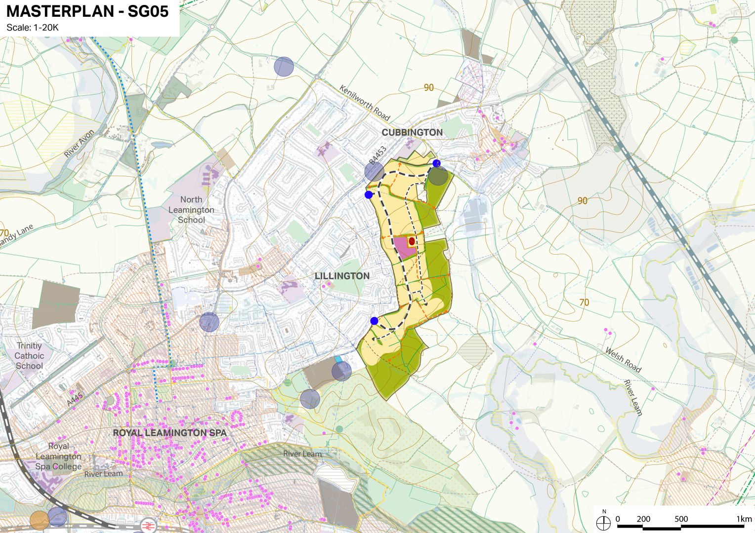
Proposal LEA.3 (Site Proposal) ~ Requirements
Leamington Spa - Land to East (Lillington)
Site Size
83 hectares (ha) of which 69ha to be released from the green belt comprising of:
- A minimum of 1,455 dwellings across 38 ha, with affordable housing provided in accordance with Policy DS.4
- 43 ha of Public Open Space including areas of play, allotments, biodiversity and public rights of way. 14 ha retained in the Green Belt in the South East corner.
Summary
The vision for Leamington Spa East is to create a well-designed, inclusive and landscape-led urban extension to Lillington that forms a natural and cohesive extension to the existing town of Royal Leamington Spa. It will be a vibrant, well-connected neighbourhood that retains separation between Lillington and Cubbington through the provision of public open space.
The development will act as a model of sustainable living, contributing to a net-zero future and embracing principles of a 20-minute neighbourhood, integrating with the surrounding area through a network of green spaces and active travel routes, most notably through Newbold Comyn Country Park. It will foster a healthy community engaged with nature through a commitment to long-term environmental stewardship.
Land within this allocation will be developed to deliver approximately 1,455 new homes within the plan period, alongside necessary supporting infrastructure. This will include a new 2 Form of Entry Primary School and Public Open Space, including a new Cubbington Community Park. It will be vital for development to ensure the delivery of a network of walking and cycling links between Lillington, Cubbington and Newbold Comyn.
Timescale
Anticipated to be delivered in the period 2031/32-2040/41. Opportunities for early delivery through phasing would be encouraged. This is provided that appropriate measures are in place to ensure the allocation is developed coherently and in accordance with a coordinated site-wide masterplan, to be agreed upon prior to any submission by all parties.
Key Development and Land Use Requirements
- Housing: the delivery of approximately 1,455 homes across 38ha.
- Education: Provision of 2ha of land for a two-form of entry primary school.
- Local Centre: Provision of 0.1ha of land for a local centre providing a range of uses to meet the needs of existing and future residents.
- Public Open Space: The provision of 42 ha of Public Open Space, including a new Cubbington Community Park.
- A network of walking and cycling routes within the site connecting to neighbouring settlements, Newbold Comyn and the surrounding countryside beyond.
Infrastructure Funding Requirements
Infrastructure will be provided through a Section 106 agreement or Community Infrastructure Levy as considered appropriate.
It is vital to ensure sufficient primary and secondary education capacity in the area to support the growth in local needs resulting from the development. Off-site contributions may be required to ensure that this in place, when considering in-combination effects with LEA.1 and LEA.2. Consideration must be given to the lack of existing identified capacity at the North Leamington School. Likewise, contributions will also be required for additional healthcare facilities. Opportunities should be explored to determine the appropriate uses for a local centre on site. the appropriate uses for a local centre on site. Development proposals should look to secure opportunities to support the continued operation and regeneration of local facilities, including the Lillington Community Centre, and align with the objectives of the Cubbington Neighbourhood Plan. Development proposals will need to ensure that the two 11kV overhead power lines that cross the site are diverted appropriately. The phasing of infrastructure provision must be agreed as part of any site-wide masterplan.
Urban Design Principles
Urban design should be guided by the ethos of creating a sustainable residential development that forms a natural extension to the community of Lillington, whilst minimising landscape harm to the surrounding area, and offering an appropriate transition to Newbold Comyn and Cubbington.
Therefore, the fundamental design principle should be to create an effective and well-considered transition from the existing urban area of Lillington in the western areas of the site, with Public Open Space focused to the more rural areas to the south and east.
A site-wide masterplan, providing key design principles, should be prepared and agreed upon with the SWLP Councils prior to the submission of any planning application. No planning application shall be determined until a masterplan has been approved by the SWLP Councils and agreed by all parties.
The masterplan will be expected to demonstrate several key aspects of the design principles of the proposed development, ensuring a landscape-led approach that responds to the need for enhanced pedestrian access to Newbold Comyn Country Park. The layout must also create a strengthened definition of the edge of the Warwick/Leamington conurbation. The natural topography of the landscape must be considered and utilised to ensure that views are effectively filtered.
Any masterplan must ensure higher densities in areas adjacent to existing urban areas. Lower densities are more appropriate given the Site's more rural setting at its outer edges. It may be appropriate to consider subdividing the Site into sub-area neighbourhood codes that reflect more urban and rural typologies, better suited to the changing setting of the allocation.
Access, Highways and Public Transport Requirements
Vehicular access to the development will be taken from three locations, connected via an internal spine road running north/south through the site:
- New link connecting between B4453 Rugby Road/Cubbington Road and Spine Road
- New roundabout at Buckley Road/Clare Close
- New Priority Junction from Offchurch Road
Opportunities for primary access onto Rugby Road would also be considered favourably provided it can be demonstrated to the Highways Authority as practicable. Appropriate measures must be implemented as part of any transport arrangement to mitigate the additional trip generation resulting from the development.
Proposals will be required to consider impacts on the surrounding road network, working to ensure the requisite improvements identified in the Strategic Transport Assessment in the north of Royal Leamington Spa are delivered in agreement with the Highways Authority. In particular, proposals will be required to mitigate impacts on Buckley Road, Gresham Avenue & Leicester Street from additional traffic generated by the development. Careful consideration is also required regarding impacts on the Rugby Road/Kenilworth Road/Windmill Hill Junction, mitigating any harms that are identified as arising from the development.
Development proposals must ensure public transport connectivity arrangements are enhanced, utilising existing links from the Site, notably bus stops on Buckley Road, Rugby Road and Cubbington Road. Improvements to be made of the 67/67a service, increasing frequency and providing connectivity to serve hospital and Leamington town centre.
Active Travel Requirements
Enabling and enhancing accessibility for existing and future residents is a key objective for any proposals, with a particular focus on securing access from Lillington to Newbold Comyn.
Footpaths W131, W132, and W131a must be utilised for accessibility from the site to Lillington, Cubbington and the surrounding countryside. A particular asset of importance is the Shakespeare’s Avon Way which must be maintained and enhanced.
Opportunities should also be explored to enhance the connectivity for bicycle transport into Leamington Town Centre, utilising different routes, including along Cubbington Road and the National Cycle Network Route 41.
Environmental Health Requirements
Consideration must be given to the Thwaites Plant on the Northeast Boundary, with any layout ensuring that noise arising from this existing facility does not infringe on the amenity of future residents.
Delivery is expected to be coordinated between private sector promoters and end developers. Further joint working will be required with key utility providers, most notably Severn Trent, to ensure sufficient capacity at the Warwick/Longbridge Sewage Treatment Works.
Historic Environment Requirements
Proposal must assess their impact on the setting of Cubbington and Royal Leamington Spa Conservation Areas and demonstrate that any harm is avoided, or where this is not possible, minimised and clearly justified with public benefits.
Flood Risk, Drainage and Water Supply
Whilst the allocation is located within Flood Zone 1, it is situated on land that slopes towards the south and east towards the floodplain of the River Leam. As some areas are at risk of surface water flooding, the site will be required to ensure that the developable area is directed towards the most suitable locations, avoiding areas of risk and using SuDS to ensure that overall downstream effects are reduced as a result of the development.
Biodiversity and Green Infrastructure
Proposals will be required to maintain and enhance existing landscape features with biodiversity value, in particular mature trees and hedgerows. These areas are considered to have intrinsic amenity value and should be retained where possible. If this is not practicable, to enable the timely and viable delivery of the development, mitigating features should be provided on-site, with a biodiversity net gain delivered in line with national policy.
As the site falls within the Dunsmore Living Landscape, developers will be required to work positively with Warwickshire Wildlife Trust providing contributions as sought.
Public Open Space
Proposals will be expected to provide for a new Cubbington Community Park, which will include a range of features such as community allotments, formal and informal play spaces, areas for habitat restoration, and accessibility from the allocation into Cubbington.
An important design factor for public open space is improving connectivity from deprived areas of Lillington into Newbold Comyn, ensuring that there are sufficient appropriate active travel links that improve permeability between Newbold Comyn and the allocated land.
Particular care will be taken to preserve as far as possible the amenity of existing residents living either within or adjacent to the Site through the appropriate use of public open space.”
8.13 Proposal COV.1 - South of Coventry
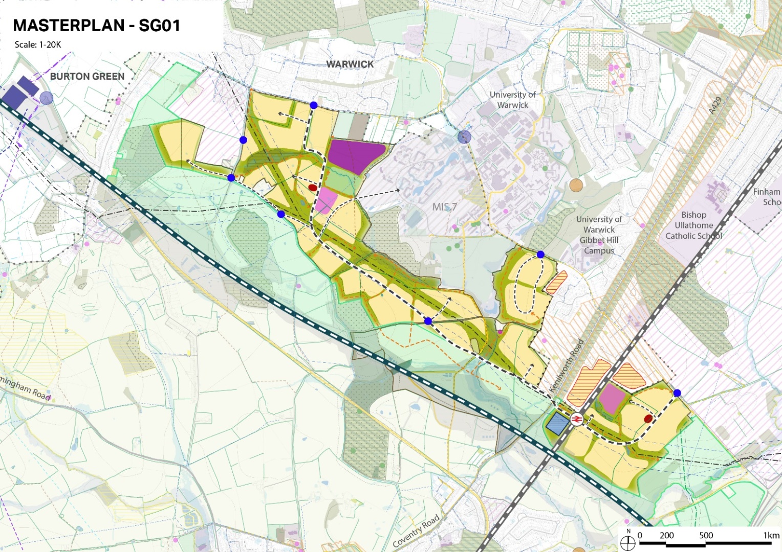
Proposal COV.1 (Site Proposal) ~ Requirements
South of Coventry
Site Size
COV.1 development area = 294ha
COV.BIO biodiversity enhancement area = 236ha
Total area = 530ha
Summary
- The land within this allocation will be developed in accordance with the illustrative Concept Plan above to deliver 4,015 dwellings to be delivered up to 2050
- 2 no. 2 forms of entry primary schools at the locations identified on the concept plan, with additional land to allow expansion up to 3 forms of entry
- Provision for 1 no. 6 form of entry secondary school and post 16 provision to be broadly located as identified on the concept plan (the requirement is dependent on the timing of secondary school delivery at Kings Hill)
- 2 no. neighbourhood centres delivered in locations in accordance with 20-minute neighbourhood principles
- Delivery of a new multimodal transport corridor through the SG01 COV.1 allocation area, linking Westwood Heath Road with the A46 Stoneleigh Junction.
- Delivery of biodiversity enhancements within the defined ‘biodiversity enhancement area and woodland park’ at COV.1.BIO.
- Public open space in accordance with Council requirements
Timescale
Likely from 2030 to 2050 and beyond
Vision and Key Development and Land Use Requirements
The strategic allocation will deliver at least 4,015 homes together with a comprehensive package of infrastructure and facilities to deliver an exemplar new community with sustainable transport infrastructure, community facilities and accessible public open spaces (including the proposed ‘biodiversity enhancement and woodland park’) as key components of the development.
Provision of an appropriate mix and size of dwellings of all tenures including affordable housing provision, in accordance with Policy DS.4. The development will provide a mix of homes, employment, education, retail, leisure, and community facilities. This will be delivered through:
Provision of a minimum 4,015 new homes.
2 no. 2 forms of entry primary schools at the locations identified on the concept plan, with additional land to allow expansion up to 3 forms of entry (one of which may accommodate the relocation and expansion of Burton Green CofE Academy), with potential nursery and specialist provision if required by the local education authority.
Provision of 1 no. 6 form of entry secondary school with post-16 and specialist provision. (This could feasibly provide ‘all through’ provision incorporating nursery and primary school provision if supported by the local education authority)
Delivery of affordable housing provision in accordance with the requirements set out in the latest Strategic Housing Market Assessment, SWLP Annex B or any successor documents
Provision of 2 no. neighbourhood centres (as indicated on the concept plan) to deliver retail, food and drink establishments, health provision (including GP provision as identified through the IDP), and other local services/amenities as required
Provision of and/or contribution to community facilities such as community buildings and sports facilities in line with the requirements set out in the latest available Infrastructure Delivery Plan, Playing Pitch Strategy and Sports Facilities Assessments
Delivery of the proposed ‘biodiversity enhancement and woodland park’
It is recognised that due to the scale of the allocation and proposed infrastructure improvements, there may be opportunities for smaller scale, non-strategic employment development within the allocation. This would provide potential employment opportunities in line with ‘20 minutes neighbourhood’ principles. Such non-strategic employment proposals will need to demonstrate that they do not undermine or prejudice delivery of the residential development requirements. Proposals will be assessed against all relevant development plan policies and taking into account all other material planning considerations such as adopted guidance.
Infrastructure Funding Requirements
The triggers and phasing for the delivery of new infrastructure and improvements to existing infrastructure will be set out in the Infrastructure Delivery Plan (or any successor document). Key infrastructure will be provided on-site with off-site mitigation measures delivered through pooled S106 contributions in coordination with key stakeholders.
Development proposals will be required to contribute to the South of Coventry Sustainable Transport Corridor improving connections to Coventry and Royal Leamington Spa in accordance with SWLP Policy ID.5.
Urban Design Principles
Proposals will be expected to demonstrate how they have accounted for the strategic design principles set out in Policy DS.19 (including Design Codes).
Development blocks will be expected to deliver minimum densities of 40 dwellings per hectare. Higher densities will be considered appropriate within areas identified for neighbourhood centres and key community facilities.
The development should be designed to deliver active frontages in the areas identified for neighbourhood centres.
Neighbourhood centres and community facilities should be designed to ensure that the development accords with 20-minute neighbourhood principles.
Development will be expected to be designed and delivered in line with the recommendations set out in the SWLP Landscape Assessment and/or the Warwickshire Landscape Guidelines. This will include accounting for elevated parts of land south of Gibbet Hill Road, and seeking to retain and enhance the characteristic features of the Arden Parklands elements of the wider Arden Landscape.
Active Travel Requirements
Provision of pedestrian and cycleway linkages across the site and between and across sub-parcels to provide access to key facilities.
Provision of segregated walking and cycling routes along the entirety of the multimodal transport corridor with appropriate crossing points as required.
Retention, and where necessary improvement, of public rights of way including variants of W164, W165, W166 and W169 routes (or necessary stopping up and diversion as agreed with the relevant highway authority).
Financial contributions towards an active travel hub at the proposed multimodal transport interchange with bike hire (and supporting facilities), secure cycle parking and onward travel information.
Access, Highways and Public Transport Requirements
Delivery of a new multimodal transport corridor through the COV.1 allocation area, linking Westwood Heath Road with the A46 Stoneleigh Junction (the access points and indicative alignment are shown on the concept plan). The multimodal transport corridor shall be designed to accommodate a variety of modes including adequate provision for pedestrians, cyclists, bus and very light rail and private vehicles. The specification for the corridor will need to be agreed with the highway authority, with specialist input from bus and very light rail operators as required. The multimodal transport corridor will need to provide an additional access to the University of Warwick campus.
Safeguarding of land (as shown on the policies map) to secure the delivery of a multimodal transport interchange comprising provision for a heavy rail station, bus-based park and ride, very light rail and active travel hubs.
Safeguarding of land (as shown on the policies map) to facilitate ‘double-tracking’ of the single-track section of railway line between Coventry and Leamington Spa.
Delivery of highway improvements and financial contributions (such as junction alterations, road widening, traffic calming, pedestrian crossings and signalisation) in accordance with the requirements set out within the Strategic Transport Assessment or Infrastructure Delivery Plan.
Provision of on-site bus infrastructure and contributions to deliver frequent bus services to serve the allocation.
Financial contributions towards other transport improvements as specified in the Infrastructure Delivery Plan and/or Strategic Transport Assessment.
Environmental Health Requirements
A contaminated land assessment will be required for the land south of Gibbet Hill Road to address the impacts associated with the historic landfill.
Adequate noise mitigation measures will be required to mitigate impacts associated with the operation of the HS2 and Coventry to Kenilworth railway lines.
Adequate air quality mitigation to address impacts from the railway or other potential sources of air pollution.
Proposals will need to consider potential amenity impacts associated with neighbouring land uses to ensure that impacts (such as noise, or light pollution/light spill) are avoided or mitigated as required. This includes protecting amenity from the schools, employment areas, neighbourhood centres and playing fields/pitches.
Historic Environment Requirements
Development will be expected to be designed and delivered in line with the recommendations set out in the SWLP Landscape Assessment and SWLP Heritage Assessment. This will include avoiding harm, and where impacts cannot be avoided adequately mitigating impacts to the following assets and their settings:
- Kenilworth Road Conservation Area
- ‘Bockendon Grange medieval moated site’ scheduled monument
- Nearby listed buildings such as Cryfield Grange Farmhouse (Grade II listed), South Hurst Farm (Grade II listed) and South Winds (Grade II listed)
Flood Risk, Drainage and Water Supply
No built development will be permitted in any part of the areas of the site which fall within Flood Zones 2 and 3. Such zones are associated with the Canley Brook.
The development will be the subject of a comprehensive Flood Risk Assessment and Drainage Strategy which will:
- Address areas at risk of ground and surface water flooding (in agreement with the relevant lead local flood authority);
- Integrate sustainable surface water management through the site throughout the lifetime of the development;
- Identify opportunities for floodwater storage through the provision of sustainable urban drainage systems (‘SuDs’), such as swales, detention basins, and permeable paving, to store and infiltrate runoff, reducing surface water entering sewer systems. Wherever possible these should be integrated with green and blue infrastructure and the public realm (as agreed with the relevant Council’s Open Spaces team); and
- Engage with local organisations such as Warwickshire Wildlife Trust or the Woodland Trust and catchment partnerships to seek opportunities for flood risk mitigation and environmental betterment
Climate Change
All development will be required to be designed and delivered in accordance with sustainable design and construction principles and net zero carbon policies set out elsewhere in the Local Plan. Development will be required to maximise opportunities for micro-generation such as through rooftop solar and air source heat pumps.
Biodiversity and Green & Blue Infrastructure
Retention and enhancement of ‘The Pools’ and ‘Whitefield Coppice’ Local Wildlife Sites (LWS). This will include enhancements, buffer zones and ecological management plans as agreed with the Warwickshire County Council Ecology and Warwick District Council Green Spaces teams
Delivery of biodiversity enhancements within the defined ‘biodiversity enhancement area and woodland park’. This area has been specifically identified to help link areas of ancient woodland, and deliver priority habitats and species. This aligns with the aims of the Local Nature Recovery Strategy which identifies the collection of ancient woodland/LWS sites as ‘areas of particular importance for biodiversity’ and the wider area as ‘areas that could become important for biodiversity’. Financial contribution will be secured from nearby developments to help deliver the biodiversity and woodland enhancements, in consultation with key stakeholders responsible for delivering and managing ecological assets and/or areas of public open space.
Delivery of continuous green and blue infrastructure corridors within COV.1 linking to adjacent networks and utilising existing and potential habitats and historic landscape. This includes retaining and linking areas of ancient woodland as well as retaining and enhancing valuable hedgerows and hedgerow trees. Proposals should also seek to deliver improvements to the Canley Brook corridor.
Delivery of continuous green and blue infrastructure corridors within COV.1 linking to adjacent networks and utilising existing and potential habitats and historic landscape. This includes retaining and linking areas of ancient woodland as well as retaining and enhancing valuable habitats (such as hedgerows, ponds and veteran or ancient trees) as identified through the Ecology Assessment, Landscape Assessment and/or other evidence Delivery of a biodiversity net gain, as per Policy BN.3-Biodiversity.
Public Open Space
Delivery of public open space in accordance with the requirements set out in the latest published standards. Such provision will need to address amenity green space, parks and gardens, natural areas of woodland, allotments, community gardens and urban farms and children & youth areas.
Developments will be required to complement and enhance any proposals delivered as part of the defined biodiversity enhancement and woodland park area
Other Constraints
Development will need to be designed and delivered in a way that preserves, conserves and where possible enhances the Gibbet Hill Middle Quarry Local Geological Site (LGS).
Development will need to be designed to account for the presence of the following pipelines with standoff zones or easements as agreed with the statutory consultees:
The Kingsbury to Blisworth oil pipeline.
The Kenilworth to Stoneleigh high pressure gas pipeline.
8.14 Proposal COV.2 - Coventry Airport
Please refer to the SWLP Reg 19 Policies Map for the concept plan.
Proposal COV.2 (Site Proposal) ~ Requirements
Coventry Airport
Site Size
117.27ha
Summary
This site is to be released from the Green Belt and allocated as a strategic site of sub-regional and regional significance to support the growth of the advanced manufacturing and engineering sector and associated innovation activities. This strategic focus reflects the Plan’s evidence and the site’s inclusion as part of the West Midlands Investment Zone.
The site provides a particular opportunity to support growth in battery manufacturing for electric vehicles, the wider battery lifecycle and associated supply chain, broader advanced manufacturing and engineering uses and innovation activities, including scalable space for research and development, incubation and associated business support. It can also deliver warehousing and logistics space.
Key Development and Land Use Requirements
Appropriate uses are considered to be those that fall within the E(g), B2 and B8 use classes. However to retain and protect the site’s strategic focus on supporting economic activities associated with advanced manufacturing and battery production:
- at least 60% of the E(g) and B-class floorspace on the site should be developed for industrial or R&D uses, comprising use classes E(g)(ii), E(g)(iii) and B2;
- development of B8 floorspace will not exceed 40% of the total employment floorspace on the site. Development of XL B8 units of over 32,500 sq.m will not be supported unless they are ancillary to or associated with a manufacturing use.
- applications for development should include a marketing strategy illustrating how the site will target investment in battery production, advanced manufacturing and engineering and associated innovation activities;
- The provision of everyday services which are ancillary to and support the business use will also be acceptable in principle. The scale of such uses should be justified and limited to serving the employment land at this location.
The site should be brought forward in a comprehensive manner.
Infrastructure Funding Requirements
- A comprehensive transport strategy is required which addressed measures and investment to optimise walking, cycling and public transport use and provide infrastructure for EV charging, from first phases of development
Urban Design Principles
- There is a requirement for high quality design and landscaping which responds to the site context and seeks to limit impacts on the settlement of Baginton and the heritage assets within it. Development will be expected to be designed and delivered in line with the recommendations set out in the SWLP Landscape Assessment and/or the Warwickshire Landscape Guidelines and the latest heritage assessments.
Active Travel Requirements
- Provision of cycle parking in accordance with published standards
Financial contributions towards off-site walking and cycling improvements including to the Baginton Gateway at Rowley Road, to the A45/A46/A444 Stivichall Junction, links from the south at Stoneleigh and Bubbenhall, Howes Lane, and within the A45 Corridor.
Access, Highways and Public Transport Requirements
- Delivery of on-site highway and transport improvements as agreed with Warwickshire County Council and Coventry City Council. This is expected to include the delivery of access via Rowley Road, Silver Eagle Way and Bubbenhall Road.
- Delivery of highway improvements and financial contributions (such junction alterations, road widening, traffic calming, pedestrian crossings and signalisation) in accordance with local highway authority requirements. This includes traffic mitigation contributions towards delivery of schemes in Baginton village and for the wider North Kenilworth/South of Coventry area. Provision of on-site bus infrastructure and contributions to deliver frequent bus services to serve the allocation
- Financial contributions towards other transport improvements as specified in the Infrastructure Delivery Plan and/or Strategic Transport Assessment
Environmental Health Requirements
- Adequate noise, air quality and light pollution mitigation measures will be required to mitigate impacts associated with the operations on site. This will include provision of adequate buffers and stand off zones where required.
- Submission of a contaminated land assessment and strategy for remediation as required
Historic Environment Requirements
- High quality design and landscaping which responds to the site context and seeks to limit impacts on the settlement of Baginton and the heritage assets within it (including Baginton Conservation Area, listed buildings and scheduled monuments).
Flood Risk, Drainage and Water Supply
A comprehensive Flood Risk Assessment and Drainage Strategy is required for the development which will:
- Address areas at risk of ground and surface water flooding (in agreement with the relevant lead local flood authority);
- Integrate sustainable surface water management through the site throughout the lifetime of the development;
Climate Change
- Development will be required to be designed and delivered in accordance with sustainable design and construction principles set out in the climate change policies. Development will be expected to maximise opportunities for micro energy generation including through rooftop solar panels on buildings or structures.
Biodiversity and Green & Blue Infrastructure
- The development will deliver a comprehensive network of green and blue infrastructure spaces and corridors, based on the landscape character of the site, which will enhance the attractiveness of the development and sustain a sense of place, promote a sense of community and social interaction among employees and encourage health and well-being
- Development will be required to retain, enhance and incorporate existing natural assets where possible
- A minimum of 10% biodiversity net gain will be required either though on-site provision or to deliver habitat creation or enhancement in a suitable location off-site through financial contributions.
Public Open Space
- Delivery of public open space on site in accordance with the requirements and standards set out in SWLP Annex C For commercial developments, this includes provision for:
- Amenity open space
- Parks and gardens
- Accessible natural areas
8.15 Proposal COV.3 – South of Coventry (Kings Hill)
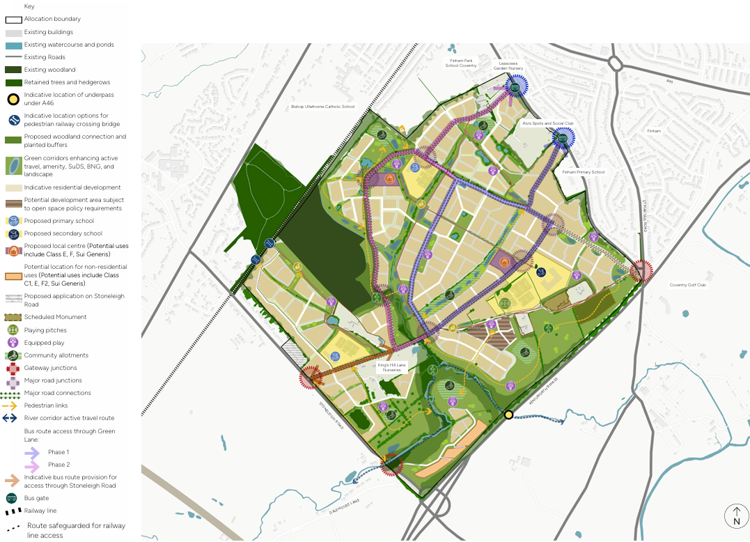
Proposal COV.3 (Site Proposal) ~ Requirements
Land South of Coventry - Kings Hill
Site Size
Total area = 269ha
Summary
The land within this allocation will be developed in accordance with the adopted Kings Hill Masterplan and Design Code and deliver:
- a minimum of 4,000 dwellings
- 2 no. 2 forms of entry primary schools at the locations identified on the illustrative masterplan, with additional land to allow expansion up to 3 forms of entry
- Provision for 1 no. 6 form of entry secondary school with post 16 and specialist provision to be broadly located as identified on the masterplan, with sufficient land to expand to up to 8 forms of entry.
- 2 no. neighbourhood centres delivered in locations in accordance with 20-minute neighbourhood principles. At least one of the neighbourhood centres (i.e. the proposed southernmost centre) will include provision for a community centre and GP surgery.
- Delivery of a new multimodal spine road through the site, linking Stoneleigh Road with the proposed new roundabout at the junction of Green Lane/St Martins Road/Howes Lane/Kings Hill Lane.
- Sports provision in accordance with published requirements (intended to be delivered with the secondary school as per the illustrative masterplan)
- Public open space in accordance with Council requirements and broadly indicated at the locations shown on the illustrative masterplan.
Timescale
Likely from 2030 to 2050
Vision and Key Development and Land Use Requirements
The strategic allocation will deliver approximately 4,000 homes together with a comprehensive package of infrastructure and facilities to deliver an exemplar new community with sustainable transport infrastructure, community facilities and accessible public open spaces as key components of the development.
Provision of an appropriate mix and size of dwellings of all tenures including affordable homes, in accordance with the mix set via the outline application or Policy HO.3. The development will provide a mix of homes, employment, education, retail, leisure, and community facilities.
Green corridors containing public open space are to be delivered across the site and include the retained Wainbody Wood Local Wildlife Site/ancient wood linking through to the Canley Brook, as well as retaining land associated with the King’s Hill deserted medieval village scheduled monument.
The development will be served by a multimodal spine route linking Stoneleigh Road with the proposed new roundabout at the junction of Green Lane/St Martins Road/Howes Lane/Kings Hill Lane. The development will also be served by bus via the proposed bus gate access(es) from Green Lane and associated bus loop through the development. The site will also ensure adequate provision for very light rail. There will also be walking and cycling routes permeating the site to encourage internalising of trips and sustainable travel.
Infrastructure Funding Requirements
Financial contributions and linked trigger points/phasing are set out within the s106 legal agreement associated with application W/18/0643 (2,500 dwellings and associated infrastructure). For remaining areas, the triggers and phasing for the delivery of new infrastructure and improvements to existing infrastructure will be set out in the Infrastructure Delivery Plan (or any successor document). Key infrastructure will be provided on-site with off-site mitigation measures delivered through pooled S106 contributions in coordination with key stakeholders.
It is intended that sports provision will be delivered to accord with the latest published requirements. The expectation is that sports pitches will be located at the secondary school, as per the illustrative masterplan, and publicly accessible through a community-use agreement.
Urban Design Principles
Proposals will be expected to demonstrate how they have accounted for the strategic design principles set out within the adopted Kings Hill Masterplan and Design Code document.
Proposals will be expected to align with the densities proposed, which range from lower density zones of 35dph on the periphery of the site to higher density zones of 50dph in central locations.
The development should be designed to deliver active frontages in the areas identified for neighbourhood centres.
Buildings are envisaged to range from 2 storey buildings at urban fringe locations up to 3 storey buildings within neighbourhood centre locations.
Proposals are expected to follow the edge condition principles set out in the Masterplan and Design Code document. This includes accounting for the Stoneleigh Road conservation area, the scheduled monument, the King’s Hill lane ‘heritage’ edge (and associated listed buildings), the existing schools and properties on Green Lane, the A46 edge, and the woodland edge associated with Wainbody Wood.
Development is also expected to align with the landscape and visual impact considerations addressed in the Kings Hill Masterplan and Design Code.
Active Travel Requirements
Provision of pedestrian and cycleway linkages across the site and between and across sub-parcels to provide access to key facilities. These should align with the routes indicated within the Masterplan and Design Code document.
Provision of segregated walking and cycling routes along the entirety of the multimodal spine road with appropriate crossing points as required.
Financial contributions towards off-site active travel schemes in accordance with the recommendations set out within the Strategic Transport Assessment.
Access, Highways and Public Transport Requirements
The development will deliver a new multimodal spine road through the site linking Stoneleigh Road with the proposed new roundabout at the Green Lane/St Martins Road/Howes Lane/Kings Hill Lane junction (the access points and indicative alignment are shown on the illustrative masterplan). The multimodal spine road shall be designed to accommodate a variety of modes including adequate provision for pedestrians, cyclists, bus, very light rail and private vehicles. The specification for the corridor will need to be agreed with the highway authority, with specialist input from bus and very light rail operators as required.
The development will be required to align with the proposed street hierarchy reflected in the Masterplan and Design Code SPD.
The development will be served by bus, with bus gate access provided on Green Lane allowing buses to access the site. Provisional bus routes are shown on the illustrative masterplan.
Some land will be safeguarded to allow a route to access the railway line to allow future double tracking of the section of line. This proposed route is reflected on the illustrative masterplan.
The development will deliver highway improvements and financial contributions (such as junction alterations, road widening, traffic calming, pedestrian crossings and signalisation) in accordance with the requirements set out within the Strategic Transport Assessment or Infrastructure Delivery Plan.
On-site bus infrastructure and contributions will be secured to deliver frequent bus services to serve the allocation.
Financial contributions will also be secured towards other transport improvements as specified in the Infrastructure Delivery Plan and/or Strategic Transport Assessment
Environmental Health Requirements
Adequate noise mitigation measures will be required to mitigate impacts associated with the Coventry to Kenilworth railway lines and main roads such as the A46.
Adequate air quality mitigation will be required to address impacts from the railway or other potential sources of air pollution.
Proposals will need to consider potential amenity impacts associated with neighbouring land uses to ensure that impacts (such as noise, or light pollution/light spill) are avoided or mitigated as required. This includes protecting amenity from the schools, employment areas, neighbourhood centres and playing fields/pitches.
Historic Environment Requirements
Development will be expected to be designed and delivered in line with the recommendations set out in Kings Hill Masterplan and Design Code. This includes delivering sensitively designed development that protects, and where possible enhances, the following assets and their settings:
- Kenilworth Road Conservation Area
- King’s Hill deserted medieval village scheduled monument
- Listed buildings on Kings Hill Lane including the Grade II listed Hill Farmhouse and the Wainbody Wood Farmhouse and associated Barn
In particular, development will need to be offset from the ancient monument and opportunities for education and interpretation associated with the scheduled monument will need to be explored.
Flood Risk, Drainage and Water Supply
No built development will be permitted in any part of the areas of the site which fall within Flood Zones 2 and 3. Such zones are associated with the Canley Brook.
The development will be expected to align with the recommendations set out in the Kings Hill Masterplan and Design Code relating to river and surface water flooding. The development will be the subject of a comprehensive Flood Risk Assessment and Drainage Strategy which will:
- Address areas at risk of river and surface water flooding (in agreement with the relevant lead flood authority);
- Integrate sustainable surface water management through the site throughout the lifetime of the development;
- Identify opportunities for floodwater storage through the provision of sustainable urban drainage systems (‘SuDs’), such as swales, detention basins, and permeable paving, to store and infiltrate runoff, reducing surface water entering sewer systems. Wherever possible these should be integrated with green and blue infrastructure and the public realm (as agreed with the relevant Council’s Open Spaces team); and
- Explore opportunities with local organisations such as Warwickshire Wildlife Trust or the Woodland Trust and catchment partnerships to seek opportunities for flood risk mitigation and environmental betterment
Climate Change
Unpermitted areas will be required to be designed and delivered in accordance with sustainable design and construction principles and net zero carbon policies set out elsewhere in the Local Plan. Development will be required to maximise opportunities for micro-generation such as through rooftop solar and air source heat pumps.
Biodiversity and Green & Blue Infrastructure
Retention and enhancement of the ‘Wainbody Wood’ Local Wildlife Site (LWS)/ancient woodland. This will include enhancements, buffer zones and ecological management plans as agreed with the Warwickshire County Council Ecology and Warwick District Council Green Spaces teams.
Development is required to deliver a network of green corridors containing public open space across the site in accordance with the illustrative masterplan. This will include providing green corridors from Wainbody Wood through to the Canley Brook, as well as providing further green corridors up to the open space and safeguarded areas associated with the scheduled monument.
Development will be expected to protect and where possible enhance existing hedgerows and mature trees, ponds and watercourses, as well delivering associated green and blue infrastructure corridors in line with the illustrative masterplan.
Public Open Space
Delivery of public open space in accordance with the requirements set out in the latest published standards. Such provision will need to address amenity green space, parks and gardens, natural areas of woodland, allotments, community gardens and urban farms and children & youth areas.
Developments will be required to align with the recommendations and proposed areas of public open space set out within the Kings Hill Masterplan and Design Code.
Other Constraints
Development will need to be designed to account for the presence of the oil pipeline impacting the southern parcel of the site.
8.16 Proposal SOU.1 - Southam – Land to East
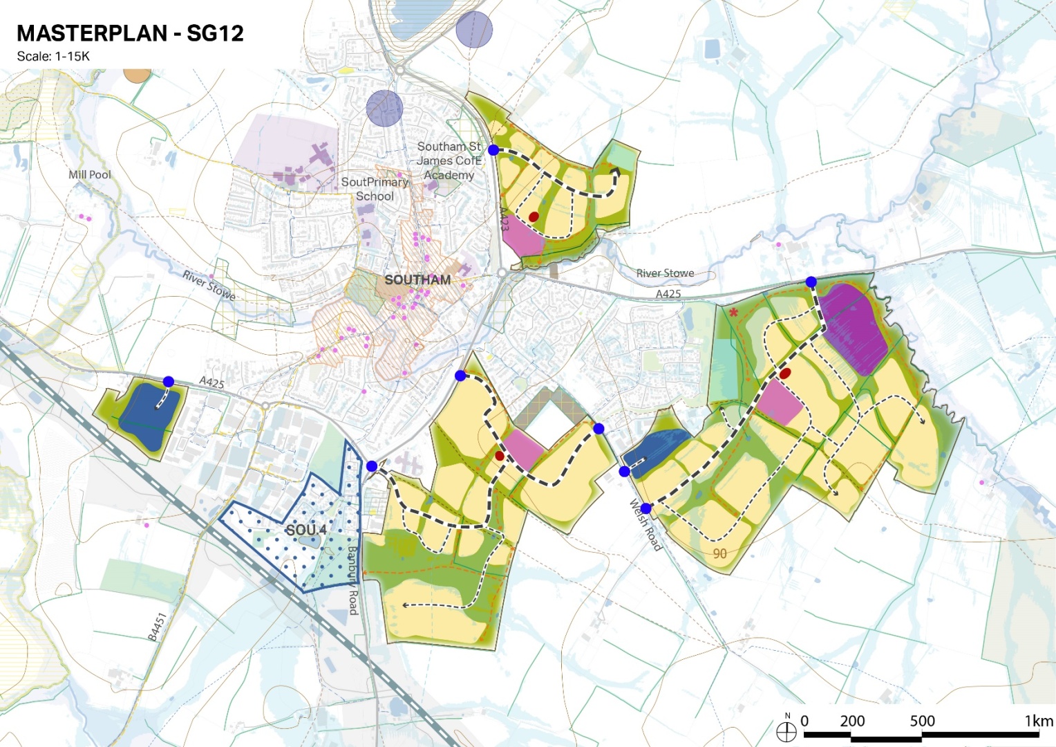
Proposal SOU.1 (Site Proposal) ~ Requirements
Land to the East of Southam
Site Size
comprising:
- A minimum of 3,122 dwellings to be delivered across 201.3 hectares.
- 2.8 hectares of employment land.
- 13 Gypsy and Traveller pitches.
- Green infrastructure, including multi-functional green spaces, areas of play, and public rights of way.
Summary
Land within the Strategic Growth Location will be developed to deliver:
- Minimum of 3,122 new homes, to be delivered within the plan period).
- 2.8 hectares of non-strategic employment land.
- 13 pitches for Gypsies and Travellers.
- 3 no. primary schools (2 forms of entry initially with scope for expansion to 3FE).
- 1 no. Secondary School at Site 135 (expansion of Southam College by 1 FE will also be required).
- 2 local centres, incorporating convenience retail, health and community facilities.
- Sports provision in accordance with Policy ID.15.
- A network of multi-functional green spaces.
- Provision of on-site bus infrastructure.
- Active travel links to Southam Town Centre.
Timescale
Anticipated to be delivered in the period 2028-2045. Opportunities for early delivery will be considered given the ability of sites to come forward in a phased manner. Where this occurs, it is vital that the development of these earlier phases does not preclude delivery of the wider site and that the early delivery of relevant infrastructure is taken into account.
Key Development and Land Use Requirements
- A minimum of 3,122 new homes to be delivered within the plan period) .
- 2.8 hectares of non-strategic employment land, comprising an extension to the existing employment area at Welsh Road East.
- 13 pitches for Gypsies and Travellers.
- 3 no. primary schools (2 forms of entry initially with scope for expansion to 3FE).
- 1 no. Secondary School at Site 135 (expansion of Southam College by 1 FE will also be required).
- 2 local centres, incorporating convenience retail, health facility and community facilities.
- Sports provision in accordance with the latest Playing Pitch Strategy and Indoor Sports Facilities studies.
- A network of multi-functional green spaces.
- Active travel links to Southam Town Centre.
- Delivery of highway improvements and financial contributions having regard to the Strategic Transport Assessment or Infrastructure Delivery Plan.
- Provision of on-site bus infrastructure and contributions to enhancements to existing services.
- Delivery of affordable housing provision in accordance with the requirements set out in SWLP Annex B, the Strategic Housing Market Assessment, Provision of and/or contribution to community facilities such as community buildings and sports facilities (in line with the requirements set out in the latest available Playing Pitch Strategy and Sports Facilities Assessments.).
- Delivery of continuous green and blue infrastructure corridors linking to adjacent networks and utilising existing and potential habitats, in particular retention and enhancement of hedgerows and hedgerow trees, and networks.
- Delivery of public open space in accordance with the requirements set out in Policy ID.15.
Infrastructure Funding Requirements
Infrastructure will be provided through a Section 106 agreement or Community Infrastructure Levy (CIL) depending on the type of contribution sought.
Urban Design Principles
- Planning applications must be supported by a Masterplan that has been agreed in advance with the Local Planning Authority.
- A consolidated Masterplan should be prepared for HELAA Sites 36, 383 and 824 in order to demonstrate that the sites will come forward in a coordinated manner and that required infrastructure will be accommodated on site (health facility and primary school).
- Proposals will be expected to demonstrate how they have accounted for the strategic design principles set out in Policy DS.19 (including Design Codes).
- Proposals will be expected to follow the 20-minute neighbourhood concept where most daily needs can be met within a short active travel trip with car use minimised.
- Development blocks will be expected to deliver minimum densities of 40 dwellings per hectare (net). Higher densities will be considered appropriate within areas identified for neighbourhood centres and key community facilities.
- The development should be designed to deliver active frontages in the areas identified for neighbourhood centres.
- Development will be expected to be designed and delivered in line with the recommendations set out in the SWLP Landscape Assessment and/or the Warwickshire Landscape Guidelines. In particular development should:
- Enhance the structure of the landscape through replanting, regeneration and management of hedgerow field boundaries to preserve the small-scale enclosed character.
- Adopt appropriate management techniques to align with priorities and actions identified as part of the emerging Warwickshire Local Nature Recovery Strategy.
- Conserve, protect and enhance existing woodland and ancient woodland, through creation of new broadleaf woodland and wood pasture habitats. Woodland enhancement will improve habitat connectivity and provide a buffer to ancient woodland.
- Incorporate new woodland planting particularly on the eastern side of Southam.
- Improve landscape connectivity, opportunity to improve wildlife connections between Long Itchington Wood, Ufton Fields, Old Ford Bridge and river edge habitats of the River Itchen south and east, where woodland is less frequent.
- Ensure any new development follows a landscape-led approach. Utilise landform variations in combination with existing vegetation and new planting to screen and filter views of new development.
- Maintain and enhance recreational access to the countryside, particularly through the areas that lie adjacent to the settlement edge, which provide valuable access to the countryside from the urban edge of Southam.
- Ensure development retains a strong sense of separation between Southam and Napton on the Hill.
- Consider woodland and hedgerow planting on the edges of new development to provide a strong settlement edge boundary.
Active Travel Requirements
- Infrastructure for active travel within the Southam Group to be undertaken in a co ordinated way, development proposals should demonstrate how neighbouring sites will be connected.
- Proposals to demonstrate how existing facilities can be improved and enhanced, including the existing pedestrian subway under the A423. Development proposals should consider the feasibility of Green Bridges over the A423 to improve active travel links. Improved crossing facilities will also be required for the A425.
- The Local Planning Authority will explore opportunities to connect National Cycle Network Routes 41 and 48 located north and south through Southam.
Access, Highways and Public Transport Requirements
Proposals will be required to:
- Demonstrate safe vehicular access onto the highway.
- Contribute to improvements to the highway network identified in the STA and IDS.
- Contribute to highway network improvements on the wider road network, required in compliance with Policy BN.16 to identify any opportunities to address existing road safety issues in the wider road network.
- Contribute towards public transport improvements and connections including:
- Improved bus frequency for Southam , with a half hourly bus to Leamington. Services between Southam-Banbury & Southam-Coventry also need to be improved
- Current indirect routes (every 2 hours) to be extended to provide a town service within Southam (664 via Cubbington/Long Itchington; 665 via Harbury & Bishops Itchington) to serve new development, plus improve frequency to every hour.
- New peak time service Southam-Gaydon.
- Contribute to enhanced bus waiting facilities on the High Street in Southam Town Centre.
Environmental Health Requirements
- Development at HELAA Site reference 134 should demonstrate that the proposals will not impact on the extant planning permission to extend Southam Quarry, consistent with the Agent of Change Principle.
Historic Environment Requirements
- Due to the known presence of Iron Age, Roman and medieval remains within and close to the Southam Group, appropriate investigation of the asset’s significance and the potential effect on this should be undertaken to identify the design of the development proposal, mitigation and implementation of the development.
Flood Risk, Drainage and Water Supply
- Areas of fluvial flood risk within the Southam Group include the north western boundary of HELAA Site 135 – the site is of sufficient size to ensure that residential development takes place within Flood Zone 1 areas and proposals for development should demonstrate this here and in other allocated sites within the Group.
- Proposals must demonstrate that areas of surface water flood risk have been similarly addressed.
- Areas of surface water flood risk must be dealt with holistically through appropriate master planning, using attenuation basins, swales and flood meadow creation to ensure appropriate, controlled discharge.
- Development will be required to ensure that the developable area is directed towards the most suitable locations, avoiding areas of risk and using SuDS to ensure that there is no worsening of downstream effects as a result of the development.
- Easements will be required along the watercourses within the relevant sites, which ideally should be free of all development. The widths of the watercourse easements will need to be agreed with the Lead Local Flood Authority (LLFA), considering the size of the watercourses, their typical flows and their maintenance requirements.
Biodiversity and Green & Blue Infrastructure
- The Southam Group of sites has potential to deliver Biodiversity Net Gain above the 10% minimum in those instances where allocations are dominated by intensively farmed arable habitats, which provides significant opportunities for enhancing the overall area of biodiverse habitats and increasing functional connectivity between features of existing value.
- Proposals should seek to retain and enhance onsite hedgerows and mature trees within the design.
- A network of SuDS features to be provided, providing wet and dry attenuation ponds and swales. These can form integral parts of the green infrastructure by ensuring a range of wildlife have access to habitats that allow them to flourish.
- Provisions for protected and priority species should be incorporated into the design of the development, including ecologically designed sustainable drainage systems (SuDS) and hibernacula for amphibians, invertebrates and reptiles, and roosting/nesting boxes for bats and birds. Proposals should demonstrate how they will contribute to maintenance and enhancement of existing Green and Blue Infrastructure, including the Stowe Valley and existing water courses.
Public Open Space
- This will be delivered through a range of different formal and informal uses including areas of play, allotments, community orchards, meadows, sports pitches and a Community Orchard and Riverside Park at Site 135.
- The exact provision of sports pitches will be in accordance with the Playing Pitch Strategy and Indoor Sports Facilities Study.
8.17 Proposal STR.1 - Stratford-upon-Avon – Land to North
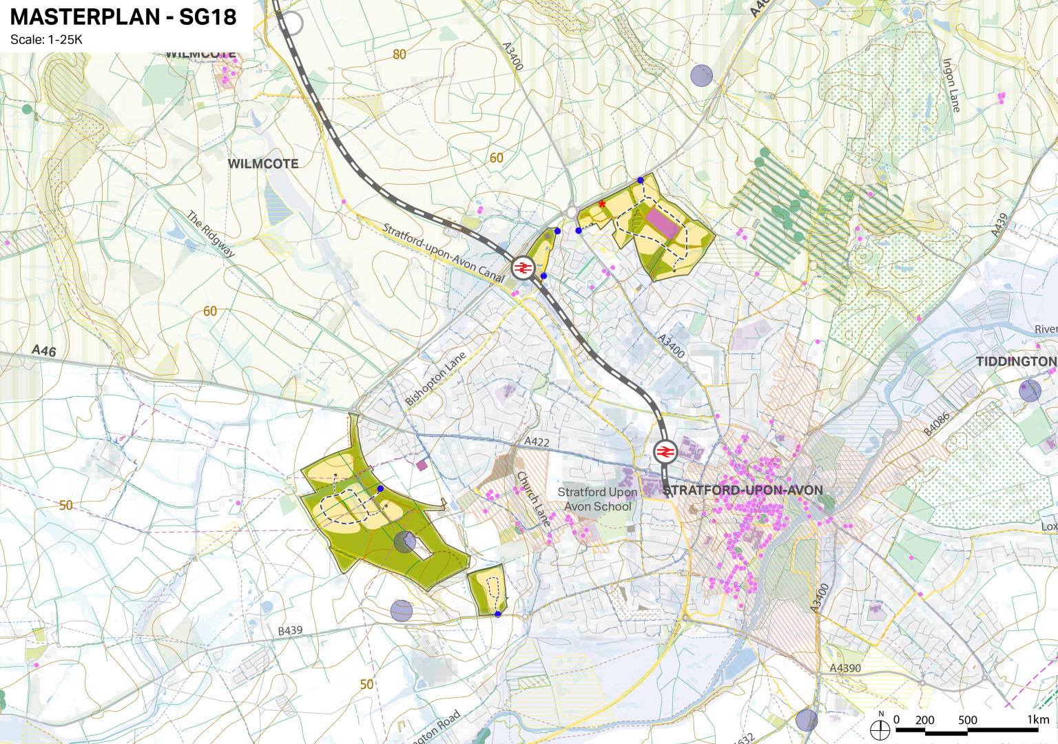
Proposal STR.1 (Site Proposal) ~ Requirements
Stratford-upon-Avon North
Location
Clopton Quarter (Northwest Stratford-upon-Avon) & Stratford-upon-Avon Park and Ride
Site Size
37.67 hectares (green belt)
Summary
The vision for Clopton Quarter is to deliver a distinctive new residential community of a minimum of 777 new high-quality homes and provide a new education facility to meet the needs of the town. The scheme will respond to the Vale Orchard landscape character, re-introducing local heritage fruits in new orchards, restoring and strengthening field patterns, creating pedestrian and cycle routes, and creating a new gateway to the Welcombe Hills Country Park.
This allocation also includes development at Stratford-upon-Avon Park and Ride and would offer approximately 139, higher density dwellings, a 2-storey decked car park to retain the existing car parking capacity, cycle parking and ancillary uses.
Timescale
From 2029/30 to 2037/38
Key Development and Land Use Requirements
- Housing:
- the delivery of a minimum of 777 dwellings comprised of a mixture of sizes and types of dwellings, in line with the latest Strategic Housing Market Assessment (SHMA).
- Provision of affordable housing in accordance with Policy DS.4
- 4 Gypsy and Traveller pitches.
- Education: The provision of land for one new education facility to meet the needs of the town.
- Public Open Space:
- An area of land dedicated exclusively to Biodiversity Net Gain.
- New community orchards.
- A variety of public open spaces for recreation and activity including natural accessible green-space, outdoor sport and allotments and community gardens.
- Active Travel Routes: Active travel connections linking to existing pedestrian routes within the surrounding urban area.
- Other: A new mixed use pedestrian gateway into Welcombe Hills Country Park, including a new visitor centre, retail, café and parking.
Stratford-upon-Avon Park and Ride
- The delivery of approximately 139 dwellings at a density of 90dph
- A 2-storey decked car park with approximately 390 car parking spaces per floor.
- Cycle parking.
- Other, ancillary uses supporting the development.
Infrastructure Funding Requirements
- On site contributions:
- Land reserved for a new education facility aligned to the needs of the community
- Direct links to Welcombe Hills Country Park including a café/tourism hub, retail offering and visitor parking
- A variety of public open spaces
- Active travel connections linking to existing non-car routes within the urban area
- Off site contributions:
- Junction improvements, informed by strategic transport modelling and a site specific transport assessment
- Education and healthcare contributions, aligned with local needs
- Integration with wider Biodiversity Net Gain (BNG) initiatives
Urban Design Principles
- Reduced density and suitable setback at northeast edge of site as it meets the new green belt boundary
- Suitable measures must be in place along the northwest edge of the site to mitigate noise and pollution from the A46
- Built development to avoid the existing copse at the centre of the site
- Residential development to be effectively integrated at gateway to new country park connection
- Proposals will be expected to follow the 20-minute neighbourhood concept where most daily needs can be met within a short active travel trip with car use minimised.
Stratford-upon-Avon Park and Ride
- Residential development kept to the east of the site, allowing the decked car park to provide noise buffering at the edge of the A46 to the northwest
- Decked car park and residential building to be of high quality design and accommodate ground floor ancillary use
- Separate Park and Ride traffic from residential access and servicing
- Ensure sensitive integration with existing residential development
- Provide coherent and safe pedestrian movement throughout the site linking to surrounding footpath/cycle network
Active Travel Requirements
- New pedestrian and cycle routes across site, linking to existing provision in the surrounding urban area
Access, Highways and Public Transport Requirements
- Primary vehicular access via new roundabout to the eastern boundary of the A46
- Separate vehicular access off Birmingham Road serving smaller portion of site
- Emergency vehicular access provided off Highfield Road
Stratford-upon-Avon Park and Ride
- Primary vehicular access to Park and Ride via existing access at Bishopton Lane
- Primary vehicular access to residential development via separate access further south of Bishopton Lane
Environmental Health Requirements
- Noise and air pollution from A46 to be mitigated through an appropriate level of setback and screening
Historic Environment Requirements
- Development proposals must consider their impact in relation to the following nearby heritage assets and must be sensitive to the presence of them and avoid substantial harm:
- Grade II Listed Clopton House lies to the east of the site with associated Grade II features at its western curtilage
- A small collection of Grade II buildings within the urban area to the southwest including Bishopton House, The Lodge, The Limes and Linden House
- Non designated Clopton Park immediately adjacent (south-east and north-east) of the site
Flood Risk, Drainage and Water Supply
- All proposals must be prepared in accordance with Policy ID.9 – Reducing Flood Risk
- Applicants will be expected to work positively with Severn Trent Water, and ensure that appropriate measures are in place at Stratford – Milcote sewage treatment works to facilitate the development's progress.
- The site is partially located within Flood Zone 2 and 3; proposals will be expected to account for this through appropriate design and SuDs application
Climate Change
- All homes will be required to engage in sustainable design and construction, including the use of renewable and low-carbon energy, in accordance with Policies NZ.1 - Operational Net Zero in New Residential Buildings, NZ.3 Embodied Carbon and NZ.5 Climate Resilient Design.
Biodiversity and Green & Blue Infrastructure
- Proposals will be required to maintain and enhance, where possible, existing landscape features with biodiversity value, in particular mature trees and hedgerows.
- If this is not practicable, to enable the timely and viable delivery of the development, mitigating features should be provided on-site, with a biodiversity net gain delivered in line with national policy and the relevant BNG policies laid out elsewhere in the SWLP.
Public Open Space
- Proposals will provide public open space in accordance with the standard sets out in Policy ID.14offering diverse typologies for recreation and amenity.
- Proposals will provide sensitive integration with the Welcombe Hills Country Park.
8.18 Proposal STR.2 - Stratford-upon-Avon – Land to South-east
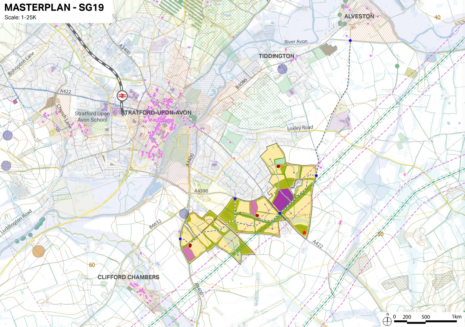
Proposal STR.2 (Site Proposal) ~ Requirements
Southeast of Stratford-upon-Avon
Site Size
174.45 ha
Summary
Land Southeast of Stratford-upon-Avon will deliver a residential-led development of a minimum of 2,727 new homes. The development will include a new secondary school, 2 new primary schools, a new spine road through the site, mobility hub, multiple area of public open space and supporting social infrastructure.
Timescale
2030/31 – 2048/49
Key Development and Land Use Requirements
- Housing: the delivery of approximately 2,727 dwellings in the period to 2050 comprised of a mixture of sizes and types of dwellings, in line with the latest Strategic Housing Market Assessment (SHMA)
- Community & Leisure:
- Convenience and community facilities
- Mobility hub
- Accessible links to the existing Rosebird Centre
- Education:
- 2 new primary schools (2FE/3FE)
- 1 new secondary school (6FE)
- Health:
- On-site health facility within local centre
- Highways/Connectivity:
- Delivery of a new spine road through the site connecting Shipston Road and Banbury Road
- Public open space:
- Multiple areas of public open space across site
- Larger area of BNG focused public parkland to the east
- Other
- 15 Pitches for Gypsies and Travellers at 0.05ha per pitch
Infrastructure Funding Requirements
- Funding contributions towards local community facilities and health services where necessary.
Urban Design Principles
- A consolidated Masterplan must be prepared for the whole of the allocated site
- Development blocks will deliver minimum densities of 40 dwellings per hectare (net). Higher densities will be considered appropriate within areas identified for neighbourhood centres and key community facilities
- Proposals will be expected to follow the 20-minute neighbourhood concept where most daily needs can be met within a short active travel trip with car use minimised.
- Development will be expected to be designed and delivered in line with the recommendations set out in the SWLP Landscape Assessment and/or the Warwickshire Landscape Guidelines. In particular development should:
- Ensure development does not result in any perceived coalescence between Stratford-upon-Avon and Clifford Chambers and retain a rural buffer function
- Ensure development maintains separation between Tiddington and the eastern edge of Stratford-upon-Avon
- Protect the open and undeveloped skyline by restricting building heights and avoiding visually prominent development on the sloping landform on the valley sides, particularly on Alveston Hill and protect views facing south towards Meon Hill
Access, Highways and Public Transport Requirements
- Land east of Shipston Road – two main access points to be taken from Shipston Road, likely via two, 3-arm roundabouts
- Land north and south of Banbury Road – main access to be taken from Banbury Road
- Delivery of a new link road through the site connecting Shipston Road and Banbury Road with a potential further access north onto Pimlico Lane
- Significant upgrades to Pimlico Lane
Active Travel Requirements
- Pedestrian and cycle connections within the development via safe, direct and convenient active travel networks based around existing rights of way and new green corridors
- New connections to take advantage of and provide easy access to existing strategic cycling routes to nearby settlements (such as that along Banbury Road to Stratford-upon-Avon and utilising former railways)
- Footpath connections to existing development at Sonnet Park
Historic Environment Requirements
- Development proposals must consider their impact in relation to the following nearby heritage asset(s) and must be sensitive to the presence of them and avoid substantial harm:
- 3 x Grade II listed building at Alveston Hill Farmhouse
Flood Risk, Drainage and Water Supply
- Develop a surface water drainage strategy which adequately deals with any additional surface water run off generated by the development
- An assessment of sewerage capacity will be required in consultation with Severn Trent Water. If required, there may be a need to facilitate upgrades to sewage treatment capacity at Stratford- Milcote Treatment Works
Biodiversity and Green Infrastructure
- Retain and enhance existing hedgerows and tree belts
- Bridgetown Woodland and Meadows to be protected as a potentially allocated local nature reserve. Development should not result in the loss or deterioration of this site nor prevent its future designation
- The disused railway line running southwest from Trinity Way is identified as a potential local wildlife site and should also be protected
- A dedicated BNG focused public area of open space at land to the east of Boundary Lane
Public Open Space
- Multiple areas of local open space to be provided across the allocation including areas for recreation and children’s play
- Central high point and woodland at land east of Stratford-upon-Avon to remain green space, allowing views of the surrounding area and provide further ecological value
- Larger area of BNG focused public parkland to the east
Other Constraints
The development will demonstrate a clear strategy for responding to the National Gas Transmission high-pressure gas pipelines present within the site which provides evidence on how the National Gas Transmission Design Guide and Principles have been applied at the masterplanning stage and how the impact of the assets has been reduced through good design.
8.19 Proposal STR.3 – Stratford-upon-Avon – Land to West
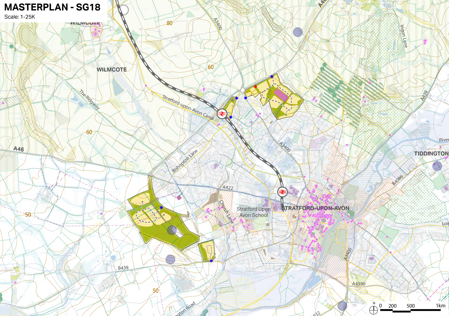
Proposal STR.3 (Site Proposal) ~ Requirements
Stratford-upon-Avon – Land to West
Site Size
64 hectares
Summary
Development at West Shottery will aim to complement the emerging Shottery View development and support the comprehensive and coordinated development of the west of Stratford-upon-Avon. It will include the delivery of a large community park, which will be a valuable new asset for the town.
Timescale
2028/29 – 2036/37.
Key Development and Land Use Requirements
Site A: West Shottery
- Housing: the delivery of a minimum 687 dwellings in the period to 2050 comprised of a mixture of sizes and types of dwellings, in line with the latest Strategic Housing Market Assessment (SHMA)
- Proposals will be expected to follow the 20-minute neighbourhood concept where most daily needs can be met within a short active travel trip with car use minimised.
- Public Open Space: extension to the existing community park to the east of the site, adjacent to Shottery Conservation Area
- The provision of a community hall and local retail facilities
- An area of safeguarded land at the western edge of the site to accommodate the proposed Stratford-upon-Avon Bypass route
Site B: Land North of Evesham Road
- Housing: the delivery of up to 130 dwellings in the period to 2050 comprised of a mixture of sizes and types of dwellings, in line with the latest Strategic Housing Market Assessment (SHMA)
- Public Open Space: c.3ha of open space to the west of the site incorporating play areas and green infrastructure
Infrastructure Funding Requirements
- Education and healthcare contributions, aligned with local needs
- Integration with wider Biodiversity Net Gain (BNG) initiatives
Urban Design Principles
Site A: West Shottery
- Built development to be kept to the north to avoid any adverse impact on the setting of Shottery Conservation Area
- Planting and green space around the perimeter of the site
- Masterplanning and design to carefully consider the area of safeguarded land required for the Stratford-upon-Avon bypass
Site B: Land North of Evesham Road
- Built development to be kept to the eastern edge of site, set back from southern boundary
- Open space located to be located at western edge of site and additional green buffer at northern and southern perimeter
Active Travel Requirements
Site A: West Shottery
- New pedestrian and cycle routes to be provided across site, linking to existing provision in the surrounding urban area and utilising the existing public rights of way
- Pedestrian/cycle crossing points along the Shottery Relief Road
Site B: Land North of Evesham Road
- Pedestrian links to be provided through site linking to the existing public right of way to the north
Access, Highways and Public Transport Requirements
Site A: West Shottery
- Primary vehicular access from Shottery Relief Road
- Emergency access via the existing track from Cottage Lane to Hansell Farm
- An area of land at the western edge of the site, shown on the proposals map will be protected to accommodate the proposed Stratford-upon-Avon Bypass route in accordance with Policy ID.4.
Site B: Land North of Evesham Road
- Primary vehicular access and separate emergency access both from Evesham Road
Historic Environment Requirements
- Development proposals must consider their impact in relation to the following nearby heritage assets and must be sensitive to the presence of them and avoid substantial harm:
- Shottery Conservation Area
- Grade I Listed Anne Hathaway’s Cottage and associated Grade II Listed Registered Park and Garden
Flood Risk, Drainage and Water Supply
- Applicants will be expected to work positively with Severn Trent Water, and ensure that appropriate measures are in place at Stratford – Milcote sewage treatment works to facilitate the development's progress.
Site A: West Shottery
- Some areas of surface water flooding at northwestern part of site to be mitigated through appropriate master planning, using attenuation basins to ensure appropriate, controlled discharge.
Climate Change
- All homes will be required to engage in sustainable design and construction, including the use of renewable and low-carbon energy, in accordance with Policies NZ.1 - Operational Net Zero in New Residential Buildings, NZ.3 - Embodied Carbon and NZ.5 - Climate Resilient Design.
Biodiversity and Green & Blue Infrastructure
- Proposals will be required to maintain and enhance, where possible, existing landscape features with biodiversity value, in particular mature trees and hedgerows.
- If this is not practicable, to enable the timely and viable delivery of the development, mitigating features should be provided on-site, with a biodiversity net gain delivered in line with national policy and the relevant BNG policies laid out elsewhere in the SWLP.
Public Open Space
- Approximately 23 hectares of public open space will be provided across both sites. 20 hectares will be provided at Site A in the form of an extension to the existing community park. A range of uses will be incorporated across both sites including recreational routes, areas of play and community orchards.
8.20 Proposal WAR.1- Warwick - Land to West
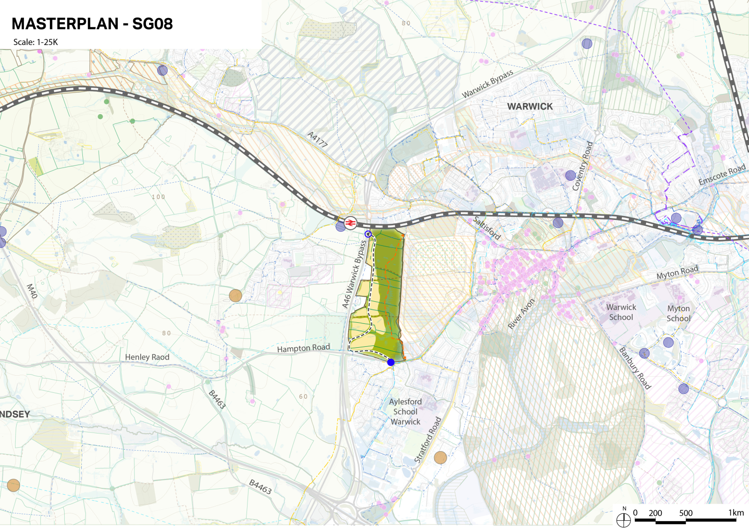
Proposal WAR.1 (Site Proposal) ~ Requirements
Warwick – Land to West
Site Size
51 hectares (Non Green Belt)
Summary
The vision for Land west of Warwick Racecourse is to deliver a high quality, sustainable new community that can enrich the historic town of Warwick by providing areas for recreation, wildlife, and flood management within the urban form. The development will also provide new sustainable and active travel routes, linking Warwick Parkway to the site and beyond into the town.
Timescale
From 2031/32 to 2040/41
Key Development and Land Use Requirements
- Housing: the delivery of a minimum of 850 dwellings in the period up to 2050 comprised of a mixture of sizes and types of dwellings, in line with the latest Strategic Housing Market Assessment (SHMA)
- Public Open Space: This will be split into multiple uses:
- Delivery of a new country park including children’s play
- Space for recreation and sport
- Pedestrian and cycle routes
- Enduring landscape buffer to the adjacent Conservation Area
- Flood management (SuDS)
- Wildlife and biodiversity enhancement
- Active Travel Routes: A new off-road pedestrian and cycle connection from the site across the A46 to Warwick Parkway Railway Station
- Other: Retention/relocation of the existing racecourse running flat
Infrastructure Funding Requirements
On site contributions:
- A spine road connecting a new roundabout junction at Hampton Road and a new priority junction at Old Budbrooke Road, with the upgrade to the existing footbridge over the A46 to facilitate road trafficOff site contributions:
- Transport/highways contributions including cycle/foothpath improvements where applicable
- Education and healthcare contributions, aligned with local needs
- Integration with wider Biodiversity Net Gain (BNG) initiatives
Development proposals will be required to contribute to the West of Warwick Sustainable Transport Corridor improving connections to Warwick via Warwick Parkway in accordance with SWLP Policy ID.5.
Urban Design Principles
- Built development must avoid areas at risk of major flooding to the east of the site
- Suitable measures must be in place along the western and southern edges of the site to mitigate noise and pollution from the A46 and the A4189 Hampton Road respectively
- Design and layout must avoid harm to the character and setting of the Warwick Conservation Area by appropriate levels of screening between the development site and the racecourse
- Proposals will be expected to follow the 20-minute neighbourhood concept where most daily needs can be met within a short active travel trip with car use minimised.
- Hedgerows and trees of higher ecological value to be retained on site
Active Travel Requirements
- The development will deliver improvements to the existing public rights of way across the site, providing enhanced connectivity within the site and out towards the town to the east
- A new pedestrian and cycle route via a linear north-south greenway will be provided and allow access to Warwick Parkway station to the north; this will be facilitated using the existing bridge to the northwest of the site
- New footway provision along the southern side of Hampton Road to connect to the existing pathways and closest bus stops
Access, Highways and Public Transport Requirements
- Primary access will be provided off the A4189 Hampton Road via a new roundabout. A second vehicular access will be provided via a new priority junction at Old Budbrooke Road and cross the existing footbridge over the A46 unless a suitable alternative access strategy can be demonstrated.
- Improved footway provision to be provided along Hampton Road to connect the site to the existing footway network and nearby bus stops
Environmental Health Requirements
- Noise and air pollution along western edge of site should be mitigated through an appropriate level of setback and screening
Historic Environment Requirements
- Development proposals must consider their impact in relation to the following heritage assets and must be sensitive to the presence of them and avoid substantial harm:
- Warwick Conservation Area (and intervisibility with Warwick Castle and St Mary’s Church)
- Castle Park
- Warwick Racecourse and St Mary’s Land
- An initial/desk-based archaeology assessment would be required in relation to the possible enclosure to the north of the site.
- Development proposals are to include an enduring landscape buffer to the adjacent Conservation Area.
Flood Risk, Drainage and Water Supply
- All proposals must be prepared in accordance with Draft Policy J – Reducing Flood Risk
- Built development must be kept to the south and western edge of the site to avoid areas at risk of major flooding to the east
- An appropriate Surface Water Management Strategy will need to be implemented on the site to attenuate the increase in surface water runoff
- A public foul water sewer line runs through the centre of the site, and it is expected that an easement should be incorporated whereby no built development takes place 5m either side of this
- Sustainable Drainage Systems (SuDS) will manage additional surface water on-site through multi-stage treatment, ensuring water quality in the wider network is protected. Where possible, SuDS features will be above ground to enhance visual amenity and support local biodiversity.
- Applicants will be expected to work positively with Severn Trent Water, and ensure that appropriate measures are in place at Longbridge Sewage Treatment Works to facilitate the development's progress.
Climate Change
- All homes will be required to engage in sustainable design and construction, including the use of renewable and low-carbon energy, in accordance with Policies NZ.1 - Operational Net Zero in New Residential Buildings, NZ.3 - Embodied Carbon and NZ.5 - Climate Resilient Design.
Biodiversity and Green & Blue Infrastructure
- Proposals will be required to maintain and enhance, where possible, existing landscape features with biodiversity value, in particular mature trees and hedgerows.
- If this is not practicable, to enable the timely and viable delivery of the development, mitigating features should be provided on-site, with a biodiversity net gain delivered in line with national policy and the relevant BNG policies laid out elsewhere in the SWLP.
- The Gog Brook, a tributary of the River Avon and LWS, should be retained and protected during construction through implementation of sensitive construction methods designed to avoid adverse effects caused by dust or silt deposition and surface water run-off.
- Warwick Racecourse lies immediately adjacent to the Site’s eastern boundary. Part of the racecourse is designated as a LWS (approximately 70m from the Site boundary), with the remainder of the racecourse identified as a potential LWS.
Public Open Space
- Proposals will be expected to provide public open space in accordance with the standard sets out in Policy ID.14
- The country park and green infrastructure will be multi-functional and provide:
- Space for recreation and sport
- Pedestrian and cycle routes
- Flood management (SuDS)
- Wildlife and biodiversity enhancement
- An important design factor for the public open space in this location is providing connectivity across the site, ensuring that there are sufficient appropriate active travel links that improve permeability between the Racecourse and the allocated land.
Other Constraints
- A Minerals Resource Assessment demonstrating compliance with the policies within the Minerals Local Plan must be provided
8.21 Proposal WEL.1 - Wellesbourne North
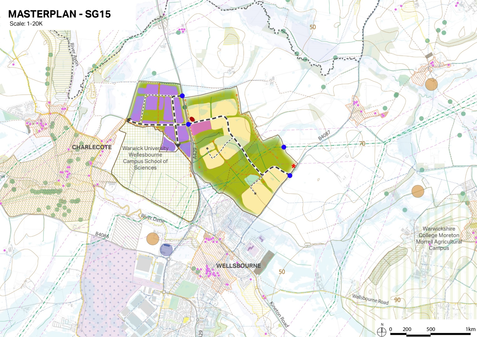
Proposal WEL.1 (Site Proposal) ~ Requirements
Wellesbourne - Land to North
Location
Land to the North of Wellesbourne(HELAA references 105, 495, 498)
Site Size
129ha comprising of:
- A minimum of 1,331 dwellings to be delivered across 97 hectares.
- 9 pitches for Gypsies and Travellers
- 2FE Primary School (with scope for expansion to 3FE)
- Public open space, including areas of play, an outdoor sports pavilion, biodiversity, and public rights of way. 47.5ha (27ha net) of employment land at Wellesbourne Campus
Summary
Land within the Strategic Growth Location will be developed to deliver:
- A minimum of 1,331 new homes, to be delivered within the plan period)
- 9 pitches for Gypsies and Travellers
- 2FE Primary School (with scope for expansion to 3FE)
- A local centre, which may need to include a health facility.
- Public open space, including areas of play, a sports pavilion, biodiversity, and public rights of way.
- Linkages to the existing highway network to improve capacity in the wider network.
- Sports provision in accordance with the latest Playing Pitch Strategy and Indoor Sports Facilities studies – including an outdoor sports pavilion.
- A network of multi-functional green spaces
- Active travel links to Wellesbourne Centre.
- 47.5ha (27ha net)of employment land primarily in research and development and office use at University of Warwick, Wellesbourne Campus
Timescale
Anticipated to be delivered from 2033-2042 in the plan period. Opportunities for early delivery will be considered given the ability of sites to come forward in a phased manner. Where this occurs, it is vital that the development of these earlier phases does not preclude delivery of the 1,550 dwellings and associated development and that the early delivery of relevant infrastructure is taken into account.
Key Development and Land Use Requirements
- A minimum of new homes, to be delivered within the plan period)
- 9 pitches for Gypsies and Travellers
- 2FE Primary School (with scope for expansion to 3FE)
- A local centre, which may need to include a health facility.
- Public open space, including areas of play, a sports pavilion, biodiversity, and public rights of way.
- Linkages to the existing highway network to improve capacity in the wider network.
- Sports provision in accordance with the latest Playing Pitch Strategy and Indoor Sports Facilities studies – including an outdoor sports pavilion.
- A network of multi-functional green spaces
- Active travel links to Wellesbourne Centre.
- Delivery of highway improvements and financial contributions having regard to the Strategic Transport Assessment or Infrastructure Delivery Plan.
- Provision of on-site bus infrastructure and contributions to enhancements to existing services.
- Delivery of affordable housing provision in accordance with the requirements set out in the Strategic Housing Market Assessment, SWLP Annex C.
- Provision of and/or contribution to community facilities such as community buildings and sports facilities (in line with the requirements set out in the latest available Playing Pitch Strategy and Sports Facilities Assessments.).
- Delivery of continuous green and blue infrastructure corridors linking to adjacent networks and utilising existing and potential habitats, in particular retention and enhancement of hedgerows and hedgerow trees, and networks.
- 47.5 ha (27ha net) of employment land primarily in research and development and office use at University of Warwick, Wellesbourne Campus to be in accordance with following Concept Plan:
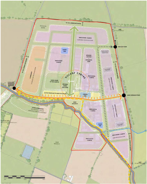
- It is envisaged that built form will constitute approximately 50% of the Concept Plan area. Development of the Wellesbourne Campus should also accord with the Character Areas Plan shown in Section 8.22 and the following height and land use requirements:
Character Area 1:
- Community uses – playing fields, gym/pavilion, nursery and relocated ancillary on-campus accommodation.
- Building heights should be between 1 and 2 storeys set back from the western edge to ensure substantial landscaped screening.
Character Area 2:
- Research and innovation uses
- Building heights should be 1-2 storeys at the Northern edge of the character area increasing to 2-3 storeys at the southern edge of the character area to front on to the ‘central loop’ of internal roadways
Character Area 3a
- Uses should include a combination of research and innovation uses, as well as collaborative activities between campus users within the innovation hubs.
- Building heights to be between 2 and 3 storeys
Character Area 3b
- Uses should include a combination of research and innovation uses, as well as collaborative activities between campus users within an innovation hub.
- North of the brook buildings should be 2 - 3 storeys in height, south of the book buildings should be 1-2 storeys in height.
Character Area 4
- Proposed uses to be focused on the campus community, providing a central community hub that integrates the different areas of the campus including a mobility hub, innovation hub and canteen, campus HQ, and some research and development uses within the landmark innovation building.
- Buildings should be between 1 and 3 storeys. Opportunity for landmark feature buildings along the central boulevard, so as to create an identity and gateway for the Campus
Character Area 5
- Uses should include a combination of research and innovation uses, in addition to centralised multi-storey car parks and a centralised waste, recycling, utilities and energy hub
Building heights should be 2 to 4 storeys along the A429 frontage with 4 storey buildings situated at the gateway to the campus. Opportunity for landmark/feature buildings facing the new campus entrance and boulevard, so as to create an identity and gateway for the Campus, integrating with the east-west central boulevard.
Infrastructure Funding Requirements
Infrastructure will be provided through a Section 106 agreement or Community Infrastructure Levy (CIL) depending on the type of contribution sought.
Urban Design Principles
- Planning applications must be supported by a Masterplan that has been agreed in advance with the Local Planning Authority.
- A consolidated Masterplan to be prepared in order to demonstrate that the sites will come forward in a coordinated manner and that required infrastructure will be accommodated on site (including health facility and primary school).
- Proposals to demonstrate how they have accounted for the strategic design principles set out in Policy DS.19 (including Design Codes).
- Development blocks to deliver minimum densities of 40 dwellings per hectare (net). Higher densities will be considered appropriate within areas identified for neighbourhood centres and key community facilities.
- Proposals will be expected to follow the 20-minute neighbourhood concept where most daily needs can be met within a short active travel trip with car use minimised.
- The development should be designed to deliver active frontages in the areas identified for neighbourhood centres.
- Development will be expected to be designed and delivered in line with the recommendations set out in the SWLP Landscape Assessment and/or the Warwickshire Landscape Guidelines. In particular development should:
- Enhance the River Dene corridor and associated riparian trees and vegetation which form a continuous landscape and ecological feature. Retain buffers around the river corridor and avoid built development that would interrupt their visual or functional continuity.
- Retain and enhance public rights of way as informal countryside routes, ensuring they continue to offer open views, rural tranquillity and access to the wider valley landscape.
- Set development back from ancient and semi-natural woodland, to protect its ecological value, landscape function, and role in containing the southern edge of the settlement.
- Delivery of employment development at Wellesbourne Campus should accord with Policy DS.5 Local Growth Locations-Employment.
Active Travel Requirements
- Infrastructure for active travel within the site should demonstrate how the site will connect with neighbouring areas.
Access, Highways and Public Transport Requirements
Proposals will be required to:
- Demonstrate safe vehicular access onto the highway.
- Provide linkages to the existing highway network to improve capacity in the wider network with links from the A429 to the west and Newbold Road to the south and a link from the A429 to Newbold Road.
- Contribute to highway network improvements on the wider road network, required in compliance with Policy BN.16 to identify any opportunities to address existing road safety issues in the wider road network.
- Contribute towards public transport improvements and connections including improvements to existing bus services to Stratford-upon-Avon and other settlements.
Historic Environment Requirements
- Protect the setting of Charlecote Park RPG to the west by avoiding built development in the western part of the site, particularly where it would be visually prominent and affect the park’s relationship with the surrounding countryside.
- Any development should be preceded by archaeological investigations to protect and record any undiscovered buried heritage.
Flood Risk, Drainage and Water Supply
- There are areas of fluvial flood risk within the Site, however – the site is of sufficient size to ensure that residential development takes place within Flood Zone 1 areas and proposals for development should demonstrate that this is the case.
- Proposals to demonstrate that areas of surface water flood risk have been similarly addressed.
- Areas of surface water flood risk must be dealt with holistically through appropriate master planning, using attenuation basins, swales and flood meadow creation to ensure appropriate, controlled discharge.
- Development will be required to ensure that the developable area is directed towards the most suitable locations, avoiding areas of risk and ensuring that there is no worsening of downstream effects as a result of the development.
- Easements will be required along the watercourses within the relevant sites, which ideally should be free of all development. The widths of the watercourse easements will need to be agreed with the Lead Local Flood Authority (LLFA), considering the size of the watercourses, their typical flows and their maintenance requirements.
Biodiversity and Green & Blue Infrastructure
- The site has potential to deliver Biodiversity Net Gain above the 10% minimum because it is currently dominated by intensively farmed arable habitats, which provides significant opportunities for enhancing the overall area of biodiverse habitats and increasing functional connectivity between features of existing value.
- Proposals should identify woodland creation activities.
- Proposals should seek to retain and enhance onsite hedgerows and mature trees within the design.
- Proposals must demonstrate how they will contribute to maintenance and enhancement of existing Green and Blue Infrastructure, including existing water courses.
Public Open Space
- Public open space to be provided in accordance with Policy ID.15.
- This should be delivered through a range of different formal and informal uses including areas of play, allotments, community orchards, and a sports pavilion.
- The exact provision of sports pitches will be in accordance with the Playing Pitch Strategy and Indoor Sports Facilities Study.
Other Constraints
The development will demonstrate a clear strategy for responding to the National Gas Transmission high-pressure gas pipelines present within the site which provides evidence on how the National Gas Transmission Design Guide and Principles have been applied at the masterplanning stage and how the impact of the assets has been reduced through good design.
8.22 Proposals STO.1, STO2 & STO3 - Stoneleigh Employment Group
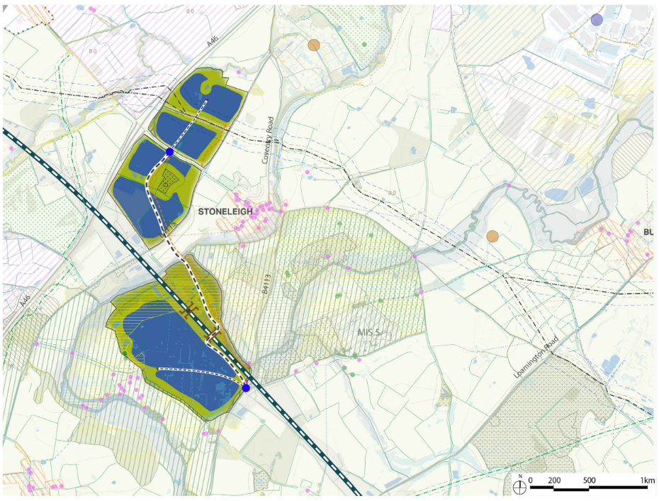
Proposals STO.1, STO2 & STO3 (Site Proposal) ~ Requirements
Stoneleigh Employment Group
Location
STO 1, 2 & 3 Stoneleigh Employment Group
Site Size
188.3ha (total site area)
Summary
Delivery of 82.3ha of gross non-strategic employment floorspace
Delivery of a new multimodal spine road through the site from Stoneleigh Road through the HS2 compound land and utilising HS2 legacy routes/infrastructure to deliver an alternative access to Stoneleigh Park (acting as a bypass to Stoneleigh village) - as indicated on the Concept Plan
Landscaping in accordance with the recommendations set out in the Council’s SWLP Landscape Assessment
Retention and enhancement of Kings Wood LWS
Sensitive landscaping to minimise impacts to the setting of heritage assets and to protect amenity of nearby residents.
Detailed minerals assessment to determine potential for prior or incidental extraction of sand and gravel.
Timescale
From 2030 to 2050 and beyond
Key Development and Land Use Requirements
Land within this allocation will be developed in accordance with the Concept Plan above to deliver:
Approximately 82.3ha of gross non-strategic employment land delivered through the following parcels:
5.4ha of net additional floorspace (Use Class B2, B8 and E(g)) to be delivered through intensification of land at the existing Stoneleigh Park site (site ref: 983)
64.9ha of new employment floorspace (Use Class B2, Use Class B8 and Use Class E(g)(iii) uses and ancillary E(g)(i) and (ii) uses) within the parcels north and south of Stoneleigh Road (site ref: 99)
12ha of new non-strategic employment floorspace (Use Class B2, Use Class B8 and Use Class E(g)(iii) uses and ancillary E(g)(i) and (ii) uses) at Manor Fields Farm (part of site 366/STO.2) (NB an appropriate buffer will need to be implemented to protect the character and setting of the grade II Pypes Mill House listed building). Due to the nature of the B4115, it is expected that access would be provided from Stoneleigh Road and through site 99.
Infrastructure Funding Requirements
Delivery of a multimodal spine route linking Stoneleigh Road with the B4113 to provide an alternative access to Stoneleigh Park and a bypass to Stoneleigh village. Development will need to be phased in a way that ensures early delivery of the full length of spine road
Provision of public open space in accordance with the SWLP Annex C. Provision will comprise amenity open space, parks and gardens and accessible natural areas.
Walking and cycling improvements to deliver links through the site from the B4113 to the B4115 to link up with wider cycle networks.
Development proposals will be required to contribute to the South of Coventry Sustainable Transport Corridor improving connections to Coventry and Royal Leamington Spa in accordance with SWLP Policy ID.5.
Urban Design Principles
Proposals will be expected to demonstrate how they have accounted for the strategic design principles set out in Policy DS.19 (including Design Codes).
Development blocks need to be designed in a way that is sensitive to the setting of the area and in a way that minimises visual impacts from the A46, Stoneleigh village and any other publicly accessible locations. Proposals will need to be informed by a comprehensive landscape and village impact assessment (LVIA).
Boundary hedgerows and trees will be retained where possible to minimise visual impact and to preserve the setting of heritage assets. Enhanced landscaping is likely to be required to further minimise heritage, visual and amenity impacts.
Active Travel Requirements
The development will be expected to deliver a publicly accessible walking and cycling route through the site linking the B4113 with the B4115 to link up with wider cycle networks. The routes will need to accord with the requirements set out in Local Transport Network LTN/120 Cycle Infrastructure Design.
An Active Travel and Sustainable Travel Strategy will need to be prepared to set out how the site will encourage and deliver more trips via walking and cycling. They should address route enhancements, cycle parking, and mobility hubs with opportunities for bicycle rental.
Access, Highways and Public Transport Requirements
Delivery of a new multimodal spine road through the site from Stoneleigh Road through the HS2 compound land and through to the B4113. This will utilise HS2 legacy routes/infrastructure to deliver an alternative access to Stoneleigh Park (acting as a bypass to Stoneleigh village). The broad alignment is shown on the Concept Plan above.
Access to the parcels north of Stoneleigh Road will be via Stoneleigh Road. A corridor will therefore need to be safeguarded within the site to allow sufficient access to the northernmost parcel.
Junction improvements on the Stoneleigh Road (either through a roundabout or signalised cross roads junction) to accommodate the developments north and south of Stoneleigh Road
Delivery of highway improvements and financial contributions (such junction alterations, road widening, traffic calming, pedestrian crossings and signalisation) in accordance with the requirements set out within the Strategic Transport Assessment or Infrastructure Delivery Plan.
Provision of on-site bus infrastructure and contributions to deliver frequent bus services to serve the allocation
Financial contributions towards other transport improvements as specified in the Infrastructure Delivery Plan and/or Strategic Transport Assessment
Financial contributions towards a high-frequency bus service with new bus stops on Stoneleigh Road, the new spine road and through the Stoneleigh Park site. This will connect the site with Coventry and Kenilworth. Bus stop facilities will comprise shelters, seating, raised kerbs and real-time information. Bus priority measures within the site and at key junctions will be implemented (where feasible).
Financial contributions towards the delivery of the multimodal transport interchange (comprising bus-based parking and ride, very light rail and heavy rail provision) east of Kenilworth Road.
Environmental Health Requirements
Adequate noise and air quality mitigation measures will be required to mitigate impacts associated with the operation of the HS2 and the A46 Kenilworth Bypass
Proposals will need to consider potential amenity impacts associated with neighbouring land uses to ensure that impacts (such as noise, or light pollution/light spill) are avoided or mitigated as required. The amenity of residents of Mary Lodge Drive, Grovehurst Park and the Cunnery will require specific consideration.
Historic Environment Requirements
Development will be expected to be designed and delivered in line with the recommendations set out in the SWLP Landscape Assessment and SWLP Heritage Assessment. Through sensitive design, the development will be expected to minimise and mitigate impacts to the following assets and their settings:
Nearby listed buildings including those associated with the Stoneleigh Abbey (Grade I) and the surrounding estate
The Stoneleigh Abbey Grade II* Registered Park and Garden
The Stoneleigh Conservation Area
The Stare Bridge Scheduled Monument
Any development will be of a height and density which can be screened by the existing planting within and around the registered park and gardens. Existing trees and hedgerows will be retained in order to screen views to and from the strategic site and, where necessary, enhanced
An adequate buffer with appropriate landscaping will need to be provided to protect the character and setting of the grade II listed Pypes Mill House
Flood Risk, Drainage and Water Supply
No built development will be permitted in any part of the areas of the site which fall within Flood Zones 2 and 3. Such zones are located along the northern western and north eastern extents of the site.
The development will be the subject of a comprehensive Flood Risk Assessment and Drainage Strategy which will:
Address areas at risk of ground and surface water flooding (in agreement with the relevant lead local flood authority);
Integrate sustainable surface water management through the site throughout the lifetime of the development;
Identify opportunities for floodwater storage through the provision of sustainable urban drainage systems (’SuDs’), such as swales, detention basins, and permeable paving, to store and infiltrate runoff, reducing surface water entering sewer systems. Wherever possible these should be integrated with green and blue infrastructure and the public realm (as agreed with the relevant Council’s Open Spaces team); and
Engage with local organisations such as Warwickshire Wildlife Trust or the Woodland Trust and catchment partnerships to seek opportunities for flood risk mitigation and environmental betterment
Climate Change
All development will be required to be designed and delivered in accordance with sustainable design and construction principles and in accordance with the Net Zero Carbon policies within the SWLP.
Development will be expected to maximise opportunities for micro energy generation including through rooftop solar panels on buildings or structures.
Biodiversity and Green & Blue Infrastructure
The development will deliver a comprehensive network of green and blue infrastructure spaces and corridors, based on the landscape character of the site, which will enhance the attractiveness of the development and sustain a sense of place, promote a sense of community and social interaction among employees and encourage health and well-being
Development will be required to retain, enhance and incorporate existing natural assets including:
the Kings Wood Local Wildlife Site/ ancient woodland, as well as other pockets of designated ancient woodland
existing hedgerows and trees (unless removal is necessary to enable development)
the ‘River Avon and Tributaries’ Local Wildlife Site
Retention of valuable habitats (such as hedgerows, ponds and veteran or ancient trees) or species as identified through the Ecology Assessment, Landscape Assessment and/or other evidence supporting the SWLP or available at the planning application stage.
Ecological management plans will need to be produced and agreed with the Warwickshire County Council Ecology and Warwick District Council Green Spaces teams
Delivery of a minimum of 10% biodiversity net gain, as agreed with the Warwickshire County Council Ecology and Warwick District Council Green Spaces teams
Public Open Space
Delivery of public open space on site in accordance with the requirements and standards set out in SWLP Annex C. For commercial developments, this includes provision for:
Amenity open space
Parks and gardens
Accessible natural areas
Other Constraints
Masterplans will need to take sufficient account of the Kingsbury to Blisworth oil pipeline that impacts the parcels north of Stoneleigh Road. Easements will need to be agreed in consultation with the British Pipeline Agency.
Based on a provisional mineral survey undertaken for STO.2 (Manor Fields site ID 366) showing resource potential to the north of the site, and the site’s location in a defined sand and gravel mineral safeguarding area, a detailed mineral assessment will be required to establish the type and quantum of resource, and to explore the potential for prior or incidental extraction as part of the development. Such assessment will need to consider potential environmental, amenity and heritage impacts given the proximity to the Grade II listed Pypes Mill House.
8.23 Stratford-upon Avon Gateway Masterplan
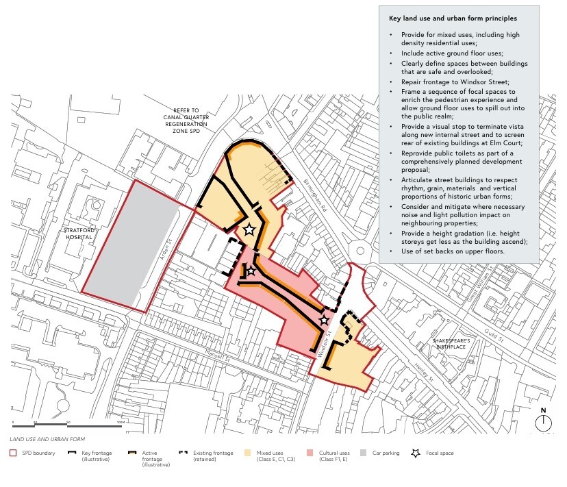
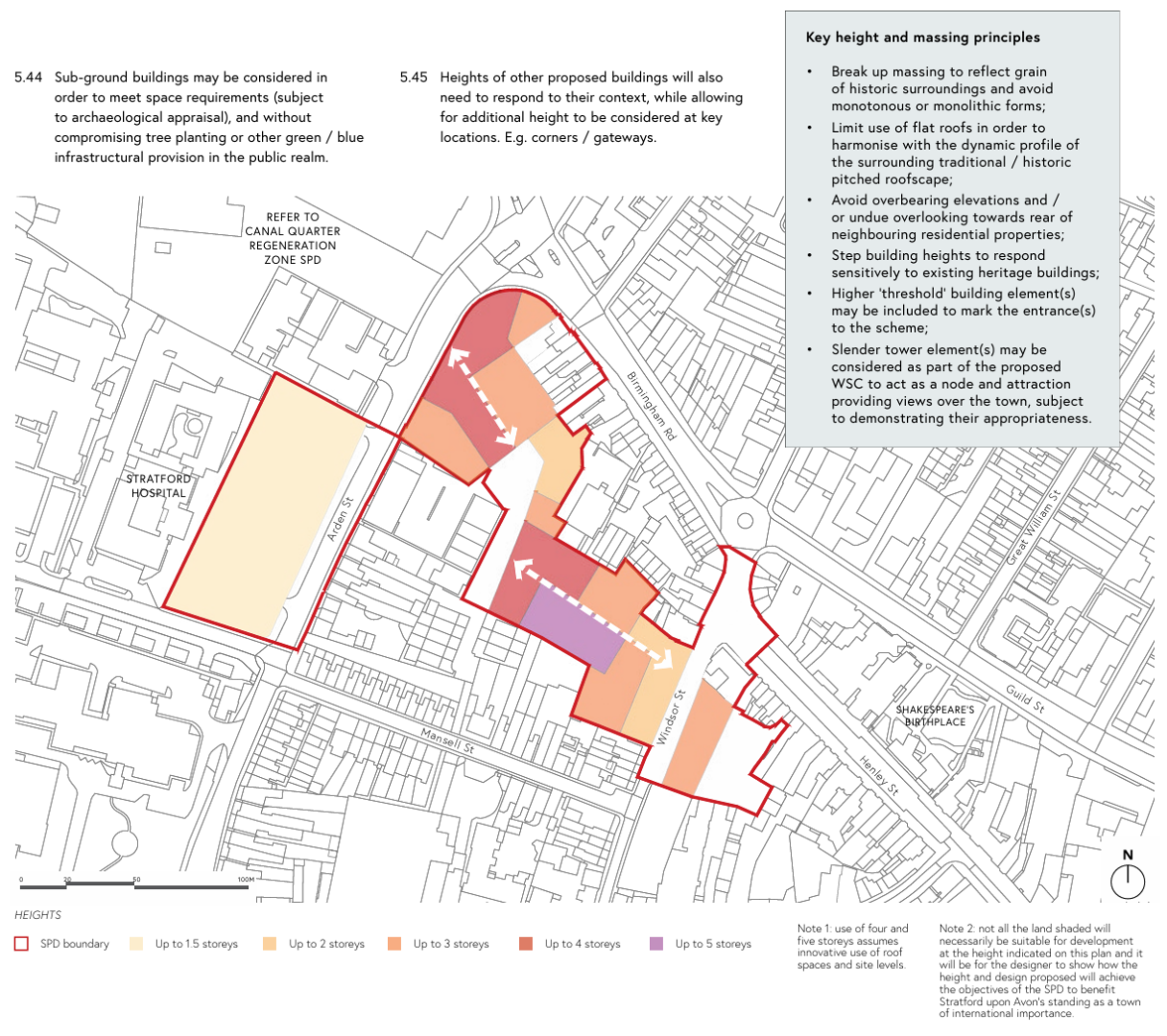
8.24 University of Warwick Wellesbourne Campus Masterplan
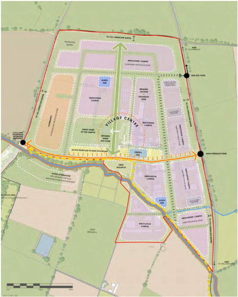
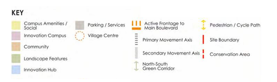
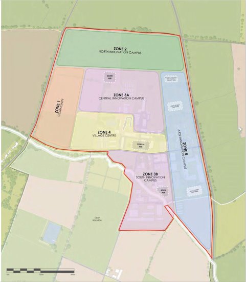
8.25 University of Warwick Main Campus Masterplan
Reflects the University’s intended proposals up to 2033